Argenton-sur-Creuse

Last updated

Argenton-sur-Creuse
Argenton-sur-Creuse (36) - Riviere.jpg
The Creuse river and surrounding buildings
Blason ville fr Argenton-sur-Creuse (Indre).svg
Location of Argenton-sur-Creuse
Argenton-sur-Creuse
France location map-Regions and departements-2016.svg
Red pog.svg
Argenton-sur-Creuse
Centre-Val de Loire region location map.svg
Red pog.svg
Argenton-sur-Creuse
Coordinates: 46°35′23″N1°31′12″E / 46.5897°N 1.52°E / 46.5897; 1.52
Country France
Region Centre-Val de Loire
Department Indre
Arrondissement Châteauroux
Canton Argenton-sur-Creuse
Intercommunality CC Éguzon - Argenton - Vallée Creuse
Government
  Mayor (20202026) Vincent Millan [1]
Area
1
29.34 km2 (11.33 sq mi)
Population
 (Jan. 2020) [2]
4,865
  Density170/km2 (430/sq mi)
Time zone UTC+01:00 (CET)
  Summer (DST) UTC+02:00 (CEST)
INSEE/Postal code
36006 /36200
Elevation99–234 m (325–768 ft)
(avg. 119 m or 390 ft)
1 French Land Register data, which excludes lakes, ponds, glaciers > 1 km2 (0.386 sq mi or 247 acres) and river estuaries.

Argenton-sur-Creuse is a commune in the Indre department in central France.

Contents

Geography

Argenton-sur-Creuse lies on the river Creuse, about 28 km southwest of Châteauroux. Argenton-sur-Creuse station has rail connections to Vierzon, Limoges and Paris. The A20 autoroute (Vierzon–Limoges–Montauban) passes west of the town. The village of Saint-Benoît-du-Sault is 20 minutes away by road. South of Argenton is the valley of the river Creuse. The village of Gargilesse is nearby; there the home of the writer George Sand may be visited.

History

The modern city is built close to the site of the Gallo-Roman city of Argentomagus which lies a little to the north. [3] The site has been developed as a museum visitor attraction. The name of the ancient town probably derives from the Latin word for "silver", as the town was a center of silver work.

The Encyclopædia Britannica Eleventh Edition (1911) described the city as follows: "The river is crossed by two bridges, and its banks are bordered by picturesque old houses. There are numerous tanneries, and the manufacture of boots, shoes and linen goods is carried on". [3] Since then, one of the riverside mills has been converted into the "Museum of the Shirt and Masculine Elegance".

Notable people

Population

Historical population
YearPop.±% p.a.
1793 4,064    
1821 3,770−0.27%
1846 4,546+0.75%
1886 6,388+0.85%
1911 6,122−0.17%
1936 5,710−0.28%
1946 6,111+0.68%
1962 6,344+0.23%
YearPop.±% p.a.
1968 6,400+0.15%
1975 6,424+0.05%
1982 5,848−1.33%
1990 5,193−1.47%
1999 5,146−0.10%
2007 5,180+0.08%
2012 5,021−0.62%
2017 4,927−0.38%
Source: EHESS [4] and INSEE (1968-2017) [5]

See also

Related Research Articles

<span class="mw-page-title-main">Aubusson, Creuse</span> Subprefecture and commune in Nouvelle-Aquitaine, France

Aubusson is a commune in the Creuse department region in central France.

<span class="mw-page-title-main">Indre</span> Department of France

Indre is a landlocked department in central France named after the river Indre. The inhabitants of the department are known as the Indriens and Indriennes. Indre is part of the current administrative region of Centre-Val de Loire and is bordered by the departments of Indre-et-Loire to the west, Loir-et-Cher to the north, Cher to the east, Creuse, and Haute-Vienne to the south, and Vienne to the southwest. The préfecture (capital) is Châteauroux and there are three subpréfectures at Le Blanc, La Châtre and Issoudun. It had a population of 219,316 in 2019.

<span class="mw-page-title-main">Haute-Vienne</span> Department of France in Nouvelle-Aquitaine

Haute-Vienne is a département in the Nouvelle-Aquitaine region in southwest-central France. Named after the Vienne River, it is one of the twelve départements that together constitute Nouvelle-Aquitaine. The prefecture and largest city in the department is Limoges, the other towns in the department each having fewer than twenty thousand inhabitants. Haute-Vienne had a population of 372,359 in 2019.

<span class="mw-page-title-main">Châteauroux</span> Prefecture and commune in Centre-Val de Loire, France

Châteauroux is the capital city of the French department of Indre, central France and the second-largest town in the province of Berry, after Bourges. Its residents are called Castelroussins in French.

<span class="mw-page-title-main">Asnières-sur-Seine</span> Commune in Île-de-France, France

Asnières-sur-Seine is a commune in the Hauts-de-Seine department and Île-de-France region of north-central France. It lies on the left bank of the river Seine, some eight kilometres from the centre of Paris in the north-western suburbs of the French capital. The inhabitants are called the Asniérois and the Asniéroises in French.

<span class="mw-page-title-main">Guéret</span> Prefecture and commune in Nouvelle-Aquitaine, France

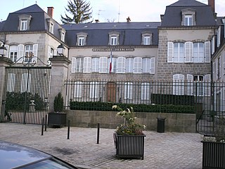
Guéret is a commune and the prefecture of the Creuse department in the Nouvelle-Aquitaine region in central France.

<span class="mw-page-title-main">Le Blanc</span> Subprefecture and commune in Centre-Val de Loire, France

Le Blanc is a commune and a subprefecture of the department of Indre, and the region of Centre-Val de Loire, central France.

<span class="mw-page-title-main">Montluçon</span> Subprefecture and commune in Auvergne-Rhône-Alpes, France

Montluçon is a commune in central France on the river Cher. It is the largest commune in the Allier department, although the department's prefecture is located in the smaller town of Moulins. Its inhabitants are known as Montluçonnais. The town is in the traditional province of Bourbonnais and was part of the mediaeval duchy of Bourbon.

<span class="mw-page-title-main">Yzeures-sur-Creuse</span> Commune in Centre-Val de Loire, France

Yzeures-sur-Creuse is a commune in the Indre-et-Loire department, central France.

<span class="mw-page-title-main">Vierzon</span> Subprefecture and commune in Centre-Val de Loire, France

Vierzon is a commune in the Cher department, Centre-Val de Loire, France.

<span class="mw-page-title-main">Descartes, Indre-et-Loire</span> Commune in Centre-Val de Loire, France

Descartes is a large village and commune in the Indre-et-Loire department in central France. It is approximately 29 kilometers east of Richelieu and about 48 kilometers east of Loudun, on the banks of the Creuse River, near the border of the French department of Vienne, and the border of the region between Centre-Val de Loire and Nouvelle-Aquitaine. It is famous for the birthplace of the French mathematician and philosopher who invented the Cartesian coordinate system, René Descartes.

<span class="mw-page-title-main">Loches</span> Subprefecture and commune in Centre-Val de Loire, France

Loches is a commune in the Indre-et-Loire department, central France.

<span class="mw-page-title-main">Route nationale 20</span> Road in France

The Route nationale 20 (N20) is a trunk road (nationale) between Paris and the frontier with Spain heading south through the heart of France and passing through the Cathedral City of Orléans and Toulouse. The road forks at Col de Puymorens with one branch being the Route nationale 22 which leads to Andorra. In winter, avalanches sometimes close the road.

<span class="mw-page-title-main">A20 autoroute</span> French road

The A20 autoroute or L'Occitane is a highway through central France. A part of France's national network of autoroutes, it is 427 kilometres (265 mi) long.

<span class="mw-page-title-main">Argentomagus</span>

The Roman city of Argentomagus was located in the Mersans plateau of central France, at the strategic point on the north bank of the river Creuse, where a Roman bridge once traversed. It was located at the crossing of two roads—Cenabum (Orléans) to Augustoritum (Limoges), and Limonum (Poitiers) to Avaricum (Bourges). The Latin name of the city meant "Silver Market." The modern town of Argenton takes its name from the ancient site of Argentomagus.

<span class="mw-page-title-main">Tournon-Saint-Martin</span> Commune in Centre-Val de Loire, France

Tournon-Saint-Martin is a commune in the Indre department in central France.

<span class="mw-page-title-main">Néons-sur-Creuse</span> Commune in Centre-Val de Loire, France

Néons-sur-Creuse is a commune in the Indre department in central France.

<span class="mw-page-title-main">Bléré</span> Commune in Centre-Val de Loire, France

Bléré is a commune in the Indre-et-Loire department in central France.

The canton of Argenton-sur-Creuse is an administrative division of the Indre department, central France. Its borders were modified at the French canton reorganisation which came into effect in March 2015. Its seat is in Argenton-sur-Creuse.

<span class="mw-page-title-main">Argenton-sur-Creuse station</span> Railway station in Argenton-sur-Creuse, France

Argenton-sur-Creuse station is a railway station in France on the Orléans–Montauban railway, located within the commune of Argenton-sur-Creuse, in the département of Indre, in the Centre-Val de Loire region. It is an SNCF train station served by trains of the Intercités and TER Centre-Val de Loire networks.

References

  1. "Répertoire national des élus: les maires". data.gouv.fr, Plateforme ouverte des données publiques françaises (in French). 2 December 2020.
  2. "Populations légales 2020". The National Institute of Statistics and Economic Studies. 29 December 2022.
  3. 1 2 Chisholm, Hugh, ed. (1911). "Argenton"  . Encyclopædia Britannica . Vol. 2 (11th ed.). Cambridge University Press. p. 475.
  4. Des villages de Cassini aux communes d'aujourd'hui: Commune data sheet Argenton-sur-Creuse, EHESS (in French).
  5. Population en historique depuis 1968, INSEE