The Duchy of Anjou was a French province straddling the lower Loire. Its capital was Angers, and its area was roughly co-extensive with the diocese of Angers. Anjou was bordered by Brittany to the west, Maine to the north, Touraine to the east and Poitou to the south. The adjectival form is Angevin, and inhabitants of Anjou are known as Angevins. In 1482, the duchy became part of the Kingdom of France and then remained a province of the Kingdom under the name of the Duchy of Anjou. After the decree dividing France into departments in 1791, the province was disestablished and split into six new départements: Deux-Sèvres, Indre-et-Loire, Loire-Atlantique, Maine-et-Loire, Sarthe, and Vienne.

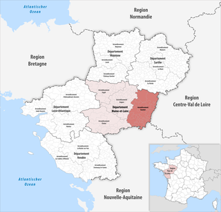
Maine-et-Loire is a department in the Loire Valley in the Pays de la Loire region in Western France. It is named after the two rivers, Maine and the Loire. It borders Mayenne and Sarthe to the north, Loire-Atlantique to the west, Indre-et-Loire to the east, Vienne and Deux-Sèvres to the south, Vendée to the south-west, and Ille-et-Vilaine to the north-west. It also borders Ille-et-Vilaine in the north for just 20 yards (19 m), France's shortest department boundary. Its prefecture is Angers; its subprefectures are Cholet, Saumur and Segré-en-Anjou Bleu. Maine-et-Loire had a population of 818,273 in 2019.

The following is a list of the 176 communes of the Maine-et-Loire department of France.

Cholet is a commune of western France, in the Maine-et-Loire department. With 54,307 inhabitants (2019), it is the second most populous commune of Maine-et-Loire, after the prefecture, Angers.

Segré is a former commune in the Maine-et-Loire department in western France. On 15 December 2016, it was merged into the new commune Segré-en-Anjou Bleu. There is a subprefecture of the Maine-et-Loire department in Segré.
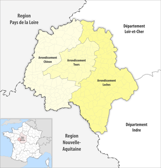
The 3 arrondissements of the Indre-et-Loire department are:
- Arrondissement of Chinon, with 106 communes. The population of the arrondissement was 103,540 in 2021.
- Arrondissement of Loches, with 112 communes. The population of the arrondissement was 116,590 in 2021.
- Arrondissement of Tours, with 54 communes. The population of the arrondissement was 392,030 in 2021.

The 3 arrondissements of the Loire-Atlantique department are:
- Arrondissement of Châteaubriant-Ancenis, with 76 communes. The population of the arrondissement was 231,576 in 2021.
- Arrondissement of Nantes, with 76 communes. The population of the arrondissement was 881,045 in 2021.
- Arrondissement of Saint-Nazaire, with 55 communes. The population of the arrondissement was 345,185 in 2021.

The 5 arrondissements of the Saône-et-Loire department are:
- Arrondissement of Autun, with 89 communes. The population of the arrondissement was 125,896 in 2021.
- Arrondissement of Chalon-sur-Saône, with 142 communes. The population of the arrondissement was 155,905 in 2021.
- Arrondissement of Charolles, with 126 communes. The population of the arrondissement was 85,124 in 2021.
- Arrondissement of Louhans, with 88 communes. The population of the arrondissement was 67,238 in 2021.
- Arrondissement of Mâcon, with 119 communes. The population of the arrondissement was 115,125 in 2021.

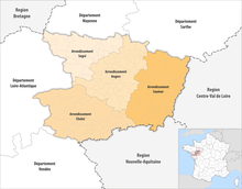
The arrondissement of Angers is an arrondissement of France in the Maine-et-Loire department in the Pays de la Loire region. It has 66 communes. Its population is 394,646 (2021), and its area is 1,753.4 km2 (677.0 sq mi).

The arrondissement of Cholet is an arrondissement of France in the Maine-et-Loire department in the Pays de la Loire region. It has 32 communes. Its population is 226,096 (2021), and its area is 2,102.5 km2 (811.8 sq mi).
The arrondissement of Saumur is an arrondissement of France in the Maine-et-Loire departement in the Pays de la Loire region. It has 52 communes. Its population is 133,080 (2021), and its area is 1,968.0 km2 (759.8 sq mi).

The arrondissement of Segré is an arrondissement of France in the Maine-et-Loire department in the Pays de la Loire region. It has 26 communes. Its population is 70,921 (2021), and its area is 1,283.0 km2 (495.4 sq mi).
The following is a list of the 21 cantons of the Maine-et-Loire department, in France, following the French canton reorganisation which came into effect in March 2015:
Canton of Cholet-1 is a canton of France, located in the Maine-et-Loire department, in the Pays de la Loire region. Since the French canton reorganisation which came into effect in March 2015, the canton contains the southwestern part of the commune of Cholet.
Canton of Cholet-2 is a canton of France, located in the Maine-et-Loire department, in the Pays de la Loire region. At the French canton reorganisation which came into effect in March 2015, the canton was expanded from 10 to 26 communes :
Canton of Beaupréau-en-Mauges is a canton of France, located in the Maine-et-Loire department, in the Pays de la Loire region. At the French canton reorganisation which came into effect in March 2015, the canton was expanded from 12 to 22 communes :

Vihiers is a former commune in the Maine-et-Loire department in western France. On 1 January 2016, it was merged into the new commune of Lys-Haut-Layon.
Baugé is a former commune in the Maine-et-Loire département in western France. On 1 January 2013, it was merged with the former communes of Montpollin, Pontigné, Saint-Martin-d'Arcé and Le Vieil-Baugé to create the commune of Baugé-en-Anjou. Since then it is a commune déléguée of this commune.

Saint-Léger-sous-Cholet is a commune in the Maine-et-Loire department in western France.
Segré-en-Anjou Bleu is a commune in the Maine-et-Loire department of western France. The municipality was established on 15 December 2016 and consists of the former communes of Aviré, Le Bourg-d'Iré, La Chapelle-sur-Oudon, Châtelais, La Ferrière-de-Flée, L'Hôtellerie-de-Flée, Louvaines, Marans, Montguillon, Noyant-la-Gravoyère, Nyoiseau, Sainte-Gemmes-d'Andigné, Saint-Martin-du-Bois, Saint-Sauveur-de-Flée and Segré. It is a subprefecture of the Maine-et-Loire department. The only hospitals are Hospital Pole Santé ,Rue Cugnot & Centre Haut Anjou