
Hauts-de-Seine is a department in the Île-de-France region of France. It covers Paris's western inner suburbs. It is bordered by Paris, Seine-Saint-Denis and Val-de-Marne to the east, Val-d'Oise to the north, Yvelines to the west and Essonne to the south. With a population of 1,624,357 and a total area of 176 square kilometres, it is the second most highly-densely populated department of France, after Paris. It is the fifth most populous department in France. Its prefecture is Nanterre, but Boulogne-Billancourt, one of its two subprefectures, alongside Antony, has a larger population.

Yvelines is a department in the western part of the Île-de-France region in Northern France. In 2019, it had a population of 1,448,207. Its prefecture is Versailles, home to the Palace of Versailles, the principal residence of the King of France from 1682 until 1789, a UNESCO World Heritage Site since 1979. Yvelines' subprefectures are Saint-Germain-en-Laye, Mantes-la-Jolie and Rambouillet.

Boulogne-Billancourt is a wealthy and prestigious commune in the western suburbs of Paris, France, located 8.2 km (5 mi) from the centre of Paris. It is a subprefecture of the Hauts-de-Seine department and thus the seat of the larger arrondissement of Boulogne-Billancourt. It is also part of the Métropole du Grand Paris. Boulogne-Billancourt includes one island in the Seine: Île Seguin. With a population of 121,334 as of 2018, it is the most populous commune in Hauts-de-Seine and most populous suburb of Paris, as well as one of the most densely populated municipalities in Europe.

The 7 arrondissements of the Pas-de-Calais department are:
- Arrondissement of Arras, with 357 communes. The population of the arrondissement was 248,929 in 2016.
- Arrondissement of Béthune, with 104 communes. The population of the arrondissement was 293,991 in 2016.
- Arrondissement of Boulogne-sur-Mer, with 74 communes. The population of the arrondissement was 159,748 in 2016.
- Arrondissement of Calais, with 52 communes. The population of the arrondissement was 158,492 in 2016.
- Arrondissement of Lens, with 50 communes. The population of the arrondissement was 367,839 in 2016.
- Arrondissement of Montreuil, with 164 communes. The population of the arrondissement was 112,118 in 2016.
- Arrondissement of Saint-Omer, with 89 communes. The population of the arrondissement was 129,608 in 2016.
The following is a list of the 23 cantons of the Hauts-de-Seine department, in France, following the French canton reorganisation which came into effect in March 2015:

The 5 arrondissements of the Seine-et-Marne department are:
- Arrondissement of Fontainebleau, with 85 communes. The population of the arrondissement was 156,193 in 2016.
- Arrondissement of Meaux, with 142 communes. The population of the arrondissement was 343,169 in 2016.
- Arrondissement of Melun, with 59 communes. The population of the arrondissement was 278,808 in 2016.
- Arrondissement of Provins, with 176 communes. The population of the arrondissement was 187,405 in 2016.
- Arrondissement of Torcy, with 45 communes. The population of the arrondissement was 432,090 in 2016.

The 3 arrondissements of the Seine-Saint-Denis department are:
- Arrondissement of Bobigny, with 9 communes. The population of the arrondissement was 415,958 in 2016.
- Arrondissement of Le Raincy, with 22 communes. The population of the arrondissement was 755,392 in 2016.
- Arrondissement of Saint-Denis, with 9 communes. The population of the arrondissement was 435,310 in 2016.

The 3 arrondissements of the Aube department are:
- Arrondissement of Bar-sur-Aube, with 108 communes. The population of the arrondissement was 28,759 in 2016.
- Arrondissement of Nogent-sur-Seine, with 79 communes. The population of the arrondissement was 54,067 in 2016.
- Arrondissement of Troyes, with 244 communes. The population of the arrondissement was 226,084 in 2016.
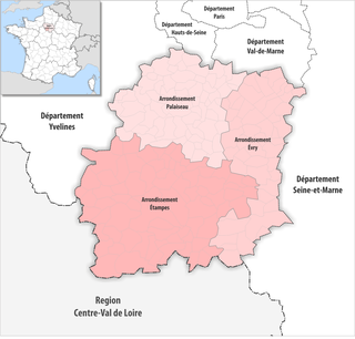
The 3 arrondissements of the Essonne department are:
- Arrondissement of Étampes, with 75 communes. The population of the arrondissement was 130,464 in 2016.
- Arrondissement of Évry, with 51 communes. The population of the arrondissement was 536,258 in 2016.
- Arrondissement of Palaiseau, with 68 communes. The population of the arrondissement was 620,608 in 2016.

The four arrondissements of the Haut-Rhin department are:
- Arrondissement of Altkirch, with 108 communes. The population of the arrondissement was 69,793 in 2016.
- Arrondissement of Colmar-Ribeauvillé, with 98 communes. The population of the arrondissement was 211,668 in 2016.
- Arrondissement of Mulhouse, with 79 communes. The population of the arrondissement was 351,012 in 2016.
- Arrondissement of Thann-Guebwiller, with 81 communes. The population of the arrondissement was 130,270 in 2016.

The 3 arrondissements of the Val-d'Oise department are:
- Arrondissement of Argenteuil, with 17 communes. The population of the arrondissement was 412,334 in 2016.
- Arrondissement of Pontoise, with 105 communes. The population of the arrondissement was 338,425 in 2016.
- Arrondissement of Sarcelles, with 62 communes. The population of the arrondissement was 471,164 in 2016.

The 3 arrondissements of the Val-de-Marne department are:
- Arrondissement of Créteil, with 16 communes. The population of the arrondissement was 310,758 in 2016.
- Arrondissement of L'Haÿ-les-Roses, with 13 communes. The population of the arrondissement was 508,854 in 2016.
- Arrondissement of Nogent-sur-Marne, with 18 communes. The population of the arrondissement was 558,539 in 2016.
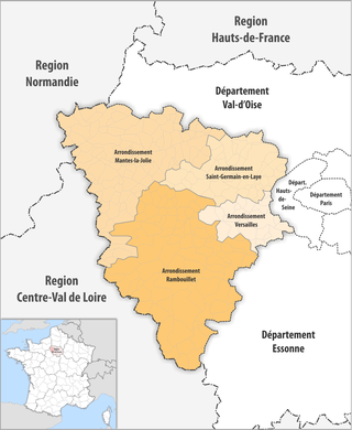
The 4 arrondissements of the Yvelines department are:
- Arrondissement of Mantes-la-Jolie, with 109 communes. The population of the arrondissement was 271,436 in 2016.
- Arrondissement of Rambouillet, with 83 communes. The population of the arrondissement was 228,196 in 2016.
- Arrondissement of Saint-Germain-en-Laye, with 44 communes. The population of the arrondissement was 518,220 in 2016.
- Arrondissement of Versailles, with 23 communes. The population of the arrondissement was 413,956 in 2016.

The arrondissement of Antony is an arrondissement of France in the Hauts-de-Seine department in the Île-de-France region. It has 11 communes. Its population is 403,229 (2019), and its area is 47.4 km2 (18.3 sq mi).

The arrondissement of Nanterre is an arrondissement of France in the Hauts-de-Seine department in the Île-de-France region. It has 17 communes. Its population is 900,667 (2019), and its area is 91.8 km2 (35.4 sq mi).

The arrondissement of Boulogne-Billancourt is an arrondissement of France in the Hauts-de-Seine department in the Île-de-France region. It has 8 communes. Its population is 320,461 (2019), and its area is 36.5 km2 (14.1 sq mi).

The arrondissement of Paris is an arrondissement of France in the Île-de-France region. It covers exactly the commune and department of Paris. Its population is 2,190,327 (2016), and its area is 105.4 km2 (40.7 sq mi).

The arrondissement of Torcy is an arrondissement of France in the Seine-et-Marne department in the Île-de-France region. It has 50 communes. Its population is 459,961 (2019), and its area is 381.8 km2 (147.4 sq mi).

The arrondissement of L'Haÿ-les-Roses is an arrondissement of France in the Val-de-Marne department in the Île-de-France region. It has 18 communes. Its population is 575,663 (2019), and its area is 88.9 km2 (34.3 sq mi).
The canton of Saint-Cloud is an administrative division of the Hauts-de-Seine department in northern France. Its borders were modified at the French canton reorganisation which came into effect in March 2015. Its seat is in Saint-Cloud. It lies within two arrondissements, Nanterre and Boulogne-Billancourt.
