
Eure-et-Loir is a French department, named after the Eure and Loir rivers. It is located in the region of Centre-Val de Loire. In 2019, Eure-et-Loir had a population of 431,575.
The following is a list of the 365 communes of the Eure-et-Loir department of France.
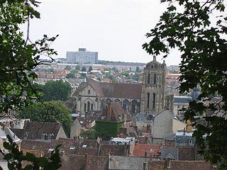
Dreux is a commune in the Eure-et-Loir department in northern France.

Châteaudun is a commune in the Eure-et-Loir department in northern France. It is a sub-prefecture of the department. It was the site of the Battle of Châteaudun during the Franco-Prussian War.

Perche is a former province of France, known historically for its forests and, for the past two centuries, for the Percheron draft horse breed. Until the French Revolution, Perche was bounded by four ancient territories of northwestern France: the provinces of Maine, Normandy, and Orléanais, and the region of Beauce. Afterwards it was absorbed into the present-day departments of Orne and Eure-et-Loir, with small parts in the neighboring departments of Eure, Loir-et-Cher, and Sarthe.
Nogent-le-Rotrou is a commune in the Eure-et-Loir department in northern France.

The 3 arrondissements of the Loir-et-Cher department are:
- Arrondissement of Blois, with 93 communes. The population of the arrondissement was 150,805 in 2016.
- Arrondissement of Romorantin-Lanthenay, with 74 communes. The population of the arrondissement was 112,145 in 2016.
- Arrondissement of Vendôme, with 100 communes. The population of the arrondissement was 69,819 in 2016.

The 3 arrondissements of the Val-de-Marne department are:
- Arrondissement of Créteil, with 16 communes. The population of the arrondissement was 310,758 in 2016.
- Arrondissement of L'Haÿ-les-Roses, with 13 communes. The population of the arrondissement was 508,854 in 2016.
- Arrondissement of Nogent-sur-Marne, with 18 communes. The population of the arrondissement was 558,539 in 2016.

The arrondissement of Chartres is an arrondissement of France in the Eure-et-Loir department in the Centre-Val de Loire region. It has 148 communes. Its population is 209,218 (2016), and its area is 2,129.5 km2 (822.2 sq mi).

The arrondissement of Châteaudun is an arrondissement of France in the Eure-et-Loir department in the Centre-Val de Loire region. It has 61 communes. Its population is 59,262 (2016), and its area is 1,438.8 km2 (555.5 sq mi).

The arrondissement of Dreux is an arrondissement of France in the Eure-et-Loir department in the Centre-Val de Loire region. It has 108 communes. Its population is 129,414 (2016), and its area is 1,500.5 km2 (579.3 sq mi).

The arrondissement of Nogent-le-Rotrou is an arrondissement of France in the Eure-et-Loir department in the Centre-Val de Loire region. It has 48 communes. Its population is 36,035 (2016), and its area is 811.1 km2 (313.2 sq mi).
The following is a list of the 15 cantons of the Eure-et-Loir department, in France, following the French canton reorganisation which came into effect in March 2015:

Nogent-le-Roi is a commune in the department of Eure-et-Loir in the Centre-Val de Loire region in France.

Châteauneuf-en-Thymerais is a commune in Eure-et-Loir department in northern France.

Senonches is a commune in Eure-et-Loir, Centre-Val de Loire, France.

The 3 arrondissements of the Eure department are:
- Arrondissement of Les Andelys, with 185 communes. The population of the arrondissement was 235,732 in 2016.
- Arrondissement of Bernay, with 297 communes. The population of the arrondissement was 227,054 in 2016.
- Arrondissement of Évreux, with 103 communes. The population of the arrondissement was 140,039 in 2016.

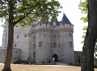
The Château Saint-Jean is a castle in the commune of Nogent-le-Rotrou in the Eure-et-Loir département of France.

The canton of Chartres-Sud-Est is a former French administrative division located in the département of Eure-et-Loir in the région of Centre-Val de Loire. It had 23,692 inhabitants (2012).
Communauté d'agglomération Chartres Métropole is an intercommunal structure, centred on the city of Chartres. It is located in the Eure-et-Loir department, in the Centre-Val de Loire region, northern France. It was created in January 2013. Its seat is in Chartres. Its area is 858.3 km2. Its population was 136,218 in 2017, of which 38,578 in Chartres proper.
