
The 7 arrondissements of the Pas-de-Calais department are:
- Arrondissement of Arras, with 357 communes. The population of the arrondissement was 249,961 in 2021.
- Arrondissement of Béthune, with 104 communes. The population of the arrondissement was 292,114 in 2021.
- Arrondissement of Boulogne-sur-Mer, with 74 communes. The population of the arrondissement was 157,817 in 2021.
- Arrondissement of Calais, with 52 communes. The population of the arrondissement was 152,091 in 2021.
- Arrondissement of Lens, with 50 communes. The population of the arrondissement was 369,427 in 2021.
- Arrondissement of Montreuil, with 164 communes. The population of the arrondissement was 110,907 in 2021.
- Arrondissement of Saint-Omer, with 89 communes. The population of the arrondissement was 129,124 in 2021.

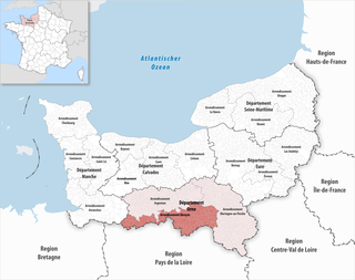
The 5 arrondissements of the Seine-et-Marne department are:
- Arrondissement of Fontainebleau, with 85 communes. The population of the arrondissement was 156,450 in 2021.
- Arrondissement of Meaux, with 139 communes. The population of the arrondissement was 342,766 in 2021.
- Arrondissement of Melun, with 59 communes. The population of the arrondissement was 289,693 in 2021.
- Arrondissement of Provins, with 174 communes. The population of the arrondissement was 186,339 in 2021.
- Arrondissement of Torcy, with 50 communes. The population of the arrondissement was 462,852 in 2021.
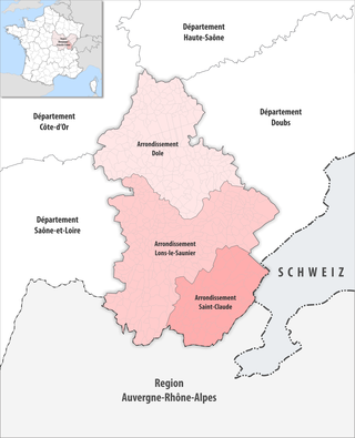
The 3 arrondissements of the Jura department are:
- Arrondissement of Dole, with 190 communes. The population of the arrondissement was 106,178 in 2021.
- Arrondissement of Lons-le-Saunier, with 249 communes. The population of the arrondissement was 104,178 in 2021.
- Arrondissement of Saint-Claude, with 55 communes. The population of the arrondissement was 48,208 in 2021.

The 3 arrondissements of the Loir-et-Cher department are:
- Arrondissement of Blois, with 93 communes. The population of the arrondissement was 151,096 in 2021.
- Arrondissement of Romorantin-Lanthenay, with 74 communes. The population of the arrondissement was 110,000 in 2021.
- Arrondissement of Vendôme, with 100 communes. The population of the arrondissement was 67,408 in 2021.

The 4 arrondissements of the Réunion department are:
- Arrondissement of Saint-Benoît, with 6 communes. The population of the arrondissement was 127,924 in 2021.
- Arrondissement of Saint-Denis, with 3 communes. The population of the arrondissement was 213,402 in 2021.
- Arrondissement of Saint-Paul, with 5 communes. The population of the arrondissement was 215,613 in 2021.
- Arrondissement of Saint-Pierre, with 10 communes. The population of the arrondissement was 314,218 in 2021.

The arrondissement of Torcy is an arrondissement of France in the Seine-et-Marne department in the Île-de-France region. It has 50 communes. Its population is 462,852 (2021), and its area is 382.5 km2 (147.7 sq mi).

The arrondissement of Blois is an arrondissement (district) of France, located in the Loir-et-Cher department, Centre-Val de Loire. It has 93 communes. Its population is 150,805 (2016), and its area is 1,950.2 km2 (753.0 sq mi).

The Arrondissement of Vendôme is an arrondissement of France, located in the Loir-et-Cher departement, region of Centre-Val de Loire. It has 100 communes. Its population is 69,819 (2016), and its area is 1,722.3 km2 (665.0 sq mi).

The arrondissement of Romorantin-Lanthenay is an arrondissement of France in the Loir-et-Cher department, in the Centre-Val de Loire region. It has 74 communes. Its population is 112,145 (2016), and its area is 2,670.9 km2 (1,031.2 sq mi).
The arrondissement of Alençon is an arrondissement of France in the Orne department in the Normandy region. It has 111 communes. Its population is 86,907 (2016), and its area is 1,548.5 km2 (597.9 sq mi).

The arrondissement of Saint-Omer is an arrondissement of France in the Pas-de-Calais department in the Hauts-de-France region. It has 89 communes. Its population is 129,608 (2016), and its area is 813.0 km2 (313.9 sq mi).

The arrondissement of Angers is an arrondissement of France in the Maine-et-Loire department in the Pays de la Loire region. It has 66 communes. Its population is 380,215 (2016), and its area is 1,740.7 km2 (672.1 sq mi).

The arrondissement of Cholet is an arrondissement of France in the Maine-et-Loire department in the Pays de la Loire region. It has 32 communes. Its population is 224,581 (2016), and its area is 2,102.5 km2 (811.8 sq mi).

The arrondissement of Segré is an arrondissement of France in the Maine-et-Loire department in the Pays de la Loire region. It has 26 communes. Its population is 70,805 (2016), and its area is 1,295.5 km2 (500.2 sq mi).

The arrondissement of La Flèche is an arrondissement of France in the Sarthe department in the Pays de la Loire region. It has 118 communes. Its population is 152,008 (2016), and its area is 2,521.4 km2 (973.5 sq mi).

The arrondissement of Mamers is an arrondissement of France in the Sarthe department in the Pays de la Loire region. It has 191 communes. Its population is 150,238 (2016), and its area is 2,904.9 km2 (1,121.6 sq mi).

The arrondissement of Le Mans is an arrondissement of France in the Sarthe department in the Pays de la Loire region. It has 45 communes. Its population is 262,997 (2016), and its area is 779.7 km2 (301.0 sq mi).

The arrondissement of Bressuire is an arrondissement of France in the Deux-Sèvres department in the Nouvelle-Aquitaine region. It has 57 communes. Its population is 109,393 (2016), and its area is 1,938.9 km2 (748.6 sq mi).

The arrondissement of Langon is an arrondissement of France in the Gironde department in the Nouvelle-Aquitaine region. It has 196 communes. Its population is 132,346 (2016), and its area is 2,644.3 km2 (1,021.0 sq mi).
The following is a list of the 21 cantons of the Sarthe department, in France, following the French canton reorganisation which came into effect in March 2015:
