Métropole du Grand Paris | |
---|---|
Country | France |
Region | Île-de-France |
Department | Paris, Essonne, Hauts-de-Seine, Seine-Saint-Denis, Val-de-Marne, Val-d'Oise |
No. of communes | 131 |
Established | 1 January 2016 |
Seat | Paris |
Government | |
• President (2020–2026) | Patrick Ollier (LR) |
Area | 814.2 km2 (314.4 sq mi) |
Population (2018) [1] | 7,075,028 |
• Density | 8,690/km2 (22,500/sq mi) |
Website | www |
Sarkozy's renovation of Paris, also known as the Grand Paris, is a vast public works programme commissioned by French president Nicolas Sarkozy between 2016 and 2030.
The Metropolis of Greater Paris (French: Métropole du Grand Paris ; French pronunciation: [metʁopɔldyɡʁɑ̃paʁi] ), [note 1] also known as Greater Paris, is a métropole covering the City of Paris and its nearest surrounding suburbs that was created from Sarkozy's renovation of the city.
The métropole came into existence on 1 January 2016; it comprises 131 communes, including Paris and all 123 communes in the surrounding inner-suburban departments of the Petite Couronne (Hauts-de-Seine, Seine-Saint-Denis and Val-de-Marne), plus seven communes in two of the outer-suburban departments, including the communes of Argenteuil in Val-d'Oise, Savigny-sur-Orge, Juvisy-sur-Orge, Viry-Châtillon and Paray-Vieille-Poste in Essonne, the last of which covers part of Orly Airport. [2] Part of the métropole comprises the Seine department, which existed from 1929 to 1968.
Grand Paris covers 814 square kilometers (314 square miles), about the size of Singapore, and has a population of over 7 million. [1] The métropole is administered by a metropolitan council of 210 members, not directly elected, but chosen by the councils of the member communes. Its responsibilities include urban planning, housing, as well as environment protection.
The idea of Greater Paris was originally proposed by French President Nicolas Sarkozy as "a new global plan for the Paris metropolitan region" [3] It first led to a new transportation master plan for the Paris region and to plans to develop several areas around Paris. The "Métropole du Grand Paris" was defined by the law of 27 January 2014 on the modernization of public territorial action and affirmation of cities as part of Act III of decentralization. The plans were considerably modified in December 2015, and the passage into action in two competences, economic development and protection of the environment was delayed from 2016 to 2017.
The plan was first announced on 17 September 2007 during the inauguration of "La Cité de l'architecture et du patrimoine", when Sarkozy declared his intent to create a "new comprehensive development project for Greater Paris". The project was organized by the French state, with the Minister of Culture and Communication charged with coordinating the consultation process. [4]
In 2008 an international urban and architectural competition for the future development of metropolitan Paris was launched. Ten teams gathering architects, urban planners, geographers, landscape architects will offer their vision for building a Paris metropolis of the 21st century in the post-Kyoto era and make a prospective diagnosis for Paris and its suburbs that will define future developments in Greater Paris for the next 40 years. [4]
The architects leading the ten multi-disciplinary teams were: Jean Nouvel, Christian de Portzamparc, Antoine Grumbach, Roland Castro, Yves Lion, Djamel Klouche, Richard Rogers, Bernardo Secchi, Paola Viganò, Finn Geipel, Giulia Andi, and Winy Maas. [5]
Early versions of the plan proposed reforms to the local government structure of the Paris region by creating an integrated urban community encompassing the City of Paris and the surrounding Petite Couronne, [6] However, these were largely abandoned due to strong opposition from the socialist Mayor of Paris, Bertrand Delanoë, and the socialist head of the Île de France region, Jean-Paul Huchon. [7]
The original plan for the Métropole declared these objectives: "The Métropole of Grand Paris is established in order to define and implement metropolitan action to improve the quality of life of its residents, reduce inequalities between regions within it, to develop an urban, social and economic sustainability model, tools to improve attractiveness and competitiveness for the benefit of the entire national territory. The Métropole of Grand Paris is developing a metropolitan project. The residents are associated with its development according to the guidelines determined by the metropolitan council as laid down by the development council. This metropolitan project defines the general guidelines of the policy pursued by the Métropole of Grand Paris. It forms part of the implementation of the overall scheme of the Ile-de-France region. It includes a general, social, economic and environmental analysis of the metropolitan area, the strategic guidelines for the development of the metropolis as well as priority areas for intervention. The Metro project can be developed with the support of the Land and Technical Agency of the Paris Region, the International Workshop on Greater Paris, the Urban Planning Agencies and any other useful body." [8]
Independently to the process described above, a position of Minister for Le Grand Paris was created and Christian Blanc was appointed to occupy it. Blanc and his team prepared a transportation plan, announced on April 29, 2009. [9] The Île-de-France region had already published its own transportation plan. Later, the architects of the consultation joined together to present a third transportation plan. After much negotiation, a compromise between the national government and the Île-de-France regional government was announced in January 2011 and the final plan subsequently approved.
The transport plan will be carried out in ten years, at a cost of 35 billion euros funded by the state, local governments and new debt. [10] An important part of the project is a driverless subway linking important business and residential poles such as Versailles and the Charles de Gaulle airport but also banlieues like Montfermeil and Clichy-sous-Bois through a figure-eight track 140 km long and operating 24-hour, which will alone cost 21 billion euros. Another 14 billion euros will be spent in the extension and re-equipment of existing metro, regional and suburban lines. [11]
The way Le Grand Paris has been handled was criticized by the architects themselves, especially by Jean Nouvel who wrote several virulent editorials against the Minister in charge of Le Grand Paris until June 2010, Christian Blanc. [12]
Politically, the President of the Île-de-France region, Jean-Paul Huchon, and the Mayor of Paris, Bertrand Delanoë, both members of the French Socialist Party, opposed the initiatives taken by the national government, which they said were against the devolution of urban planning matters to local governments. In October 2011, Delanoë stated that the President "is trying to claim for himself an urban dynamic begun long ago by the local governments". [13] Although Huchon had reached an agreement with the national government earlier in the year on the transportation network, he also declared that Grand Paris "is not a generic term to cover everything that is going on on the territory of the Île-de-France region (...) and even less a national certificate created to relabel local policies that were already in existence." [13] Political opposition was also strong from the Green Party, led in the Île-de-France region by Cécile Duflot.
The 131 communes of the Métropole du Grand Paris are grouped in 12 établissements publics territoriaux (EPT) or territoires, which replaced the existing inter-communal public institutions and inherited their competences such as sport and socio-cultural amenities, water supply, sanitation, waste management and some urban and social policies.
The Métropole du Grand Paris consists of the following 131 communes: [2] [14] [15]
Hauts-de-Seine is a department in the Île-de-France region of France. It covers Paris's western inner suburbs. It is bordered by Paris, Seine-Saint-Denis and Val-de-Marne to the east, Val-d'Oise to the north, Yvelines to the west and Essonne to the south. With a population of 1,624,357 and a total area of 176 square kilometres, it has the second highest population density among all departments of France, after Paris. It is the fifth most populous department in France. Its prefecture is Nanterre, but Boulogne-Billancourt, one of its two subprefectures, alongside Antony, has a larger population.
Seine-Saint-Denis is a department of France located in the Grand Paris metropolis in the Île-de-France region. In French, it is often referred to colloquially as quatre-vingt treize or neuf trois, after its official administrative number, 93. Its prefecture is Bobigny.
Val-de-Marne is a department of France located in the Île-de-France region. Named after the river Marne, it is situated in the Grand Paris metropolis to the southeast of the City of Paris. In 2019, Val-de-Marne had a population of 1,407,124.
Montreuil, sometimes unofficially referred to as Montreuil-sous-Bois, is a commune in the eastern suburbs of Paris, France. It is located 6.6 km (4.1 mi) from the centre of Paris, in the Seine-Saint-Denis department and in the Métropole du Grand Paris. With a population of 111,367 as of 2020, Montreuil is the third most populous suburb of Paris after Boulogne-Billancourt and Saint-Denis. It is located north of Paris's Bois de Vincennes, on the border with Val-de-Marne.
In France, a banlieue is a suburb of a large city, or all its suburbs taken collectively. Banlieues are divided into autonomous administrative entities and do not constitute part of the city proper. For instance, 80 percent of the inhabitants of the Paris metropolitan area live outside the city of Paris.
Torcy is a commune in the Seine-et-Marne department, Île-de-France, north-central France. It is located in the eastern suburbs of Paris, 21.8 km (13.5 mi) from the center of Paris.
Nogent-sur-Marne is a commune in the eastern suburbs of Paris, France. It is located 10.6 km (6.6 mi) from the centre of Paris. Nogent-sur-Marne is a sous-préfecture of the Val-de-Marne département, being the seat of the Arrondissement of Nogent-sur-Marne.
The arrondissement of Palaiseau is an arrondissement of France in the Essonne department in the Île-de-France region. It has 68 communes. Its population is 630,737 (2019), and its area is 484.0 km2 (186.9 sq mi).
The arrondissement of Le Raincy is an arrondissement of France in the Seine-Saint-Denis department in the Île-de-France region. It has 22 communes. Its population is 770,290 (2019), and its area is 149.6 km2 (57.8 sq mi).
The arrondissement of Nogent-sur-Marne is an arrondissement of France in the Val-de-Marne departement in the Île-de-France region. It has 13 communes. Its population is 510,395 (2019), and its area is 56.3 km2 (21.7 sq mi).
Noisiel is a commune in the French department of Seine-et-Marne, administrative region of Île-de-France. It is located in the eastern suburbs of Paris, 20.5 km (12.7 mi) from the center of Paris.
The Paris metropolitan area is a statistical area that describes the reach of commuter movement to and from Paris, France and its surrounding suburbs.
Croissy-Beaubourg is a French commune located in the Seine-et-Marne département, in the Île-de-France région.
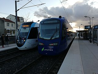
Île-de-France tramway Line 4, also called the T4, is an 13.3-kilometre (8.3 mi) long tram-train line in the Seine-Saint-Denis department of Île-de-France. The line starts at Aulnay-sous-Bois and features two branches, with the first running to Bondy and the second running to Montfermeil.
Saint-Germain-sous-Doue is a commune in the Seine-et-Marne department in the Île-de-France region in north-central France.
Métropole Rouen Normandie is the métropole, an intercommunal structure, centred on the city of Rouen. It is located in the Seine-Maritime department, in the Normandy region, north-western France. It was created in January 2015, replacing the previous Communauté d'agglomération Rouen-Elbeuf-Austreberthe. Its area is 663.8 km2. Its population was 492,681 in 2014, of which 111,360 in Rouen proper.
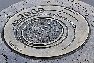
The Méridienne verte is a project devised by the architect Paul Chemetov for the 2000 celebration in France. It involved marking on the ground the Paris Meridian crossing France from North to South by planting trees along the whole line.
The Pays de France, also called the Parisis or Plaine de France, is a natural region located in the Île-de-France administrative region to the north of Paris, France. It is essentially a silt plain devoted to cereal crops, of which the southern part is included in the northern suburbs of Paris and greatly urbanised, and also includes Charles de Gaulle Airport.
The Ceinture Rouge refers to the communes of the Île-de-France that were dominated by the French Communist Party from the 1920s until the 1980s. These communes are those that are traditionally working-class areas whose residents were employed in the heavy and light industries that once dominated the economic landscape of the Petite Couronne and large population centers in the outer departments of the Île-de-France.