Ash Hill, North Carolina

Last updated

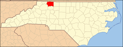
Ash Hill is an unincorporated community in the Eldora Township of Surry County, North Carolina, United States. The community is generally on the opposite side of the Ararat River from the community of Ararat and is roughly centered on Ararat Road between Eldora Road and Little Mountain Church Road. A school named Ash Hill was formerly located here. [1]

Related Research Articles

<span class="mw-page-title-main">Surry County, North Carolina</span> County in North Carolina, United States

Surry County is a county located in the U.S. state of North Carolina. As of the 2020 census, the population was 71,359. Its county seat is Dobson, and its largest community is Mount Airy.

Mountain Park is an unincorporated community located in the Bryan Township of western Surry County, North Carolina. The community's unique name is derived from its "mountain location in a park-like setting." Notable old-time musician and luthier Johnny Gentry is from Mountain Park. The most notable event is the annual Mountain Park Independence Day Celebration that is hosted by the Mountain Park Ruritan Club, which attracts between 1,000-3,000 annually.

Zephyr in an unincorporated community in western Surry County, North Carolina, United States. The community is centered on the intersection of Zephyr-Mountain Park Road and Poplar Springs Road/Zephyr Road and lies between the Mitchell River and Little Creek. Prominent landmarks in the center of the community include Gum Orchard Baptist Church and the Zephyr Cemetery.

Ararat is an unincorporated community in the Long Hill Township of Surry County, North Carolina, United States. Ararat is situated on, and is named for, the Ararat River. Ararat is along the former Atlantic & Yadkin Railway line from Mount Airy to Rural Hall that is now operated by the Yadkin Valley Railroad. Landmarks near the center of the community include the community post office, fire department and area churches.

<span class="mw-page-title-main">Eldora Township, Surry County, North Carolina</span>

Eldora Township is one of fifteen townships in Surry County, North Carolina, United States. The township had a population of 3,659 according to the 2020 census.

<span class="mw-page-title-main">Long Hill Township, Surry County, North Carolina</span>

Long Hill Township is one of fifteen townships in Surry County, North Carolina, United States. The township had a population of 1,735 according to the 2020 census.

Westfield in an unincorporated community in Surry and Stokes counties in North Carolina, United States. The community itself is located almost entirely within Surry County, with a small portion extending east into Stokes County. The majority of Westfield's Zip Code Tabulation Area is located within Stokes County.

Copeland is an unincorporated community in the Rockford Township of Surry County, North Carolina, United States.

Level Cross is an unincorporated community located in the Rockford Township of Surry County, North Carolina, United States.

Woodville in an unincorporated community located in the Westfield Township of northeast Surry County, North Carolina, United States, near Big Creek. The main thoroughfare through the community is North Carolina Highway 89.

Slate Mountain is an unincorporated community located in northeast Surry County, North Carolina, United States between the Ararat River and Archies Creek. The community of Slate Mountain is named for the nearby summit of Slate Mountain which has an elevation 1,966 feet.

Sheltontown is an unincorporated community located along North Carolina Highway 89 in northeast Surry County, North Carolina, United States, near the city of Mount Airy, just east of Bannertown. The community generally lies between Rutledge Creek and the Ararat River.

Salem is an unincorporated community located in northern Surry County, North Carolina, United States on the outskirts of the city of Mount Airy. The community generally lies between Lovills Creek and the Ararat River. Prominent landmarks include Salem United Methodist Church.

White Sulphur Springs is an unincorporated community in Surry County, North Carolina, United States on the outskirts of the city of Mount Airy near the Virginia state line. The community sits on the Ararat River and once served as a popular late-nineteenth century resort. The community's name comes from the White Sulphur Springs Hotel that once stood here.

Oak Grove is an unincorporated community in northern Surry County, North Carolina, United States, located near Bottom.

Ladonia is an unincorporated community located in the Franklin Township of northwest Surry County, North Carolina, United States. The community generally lies on the Fisher River and is centered on the intersection of Blevins Store Road and Ladonia Church Road. Area landmarks include Ladonia Baptist Church, M & M Signs and Awnings, and the nearby Raven Knob Scout Reservation.

Pine Hill is an unincorporated community in the Eldora Township of Surry County, North Carolina, United States. The community is centered on the intersection of Eldora Road/Quaker Church Road and North Carolina Highway 268. Prominent landmarks in the community include the Pine Hill Friends Meeting and cemetery.

<span class="mw-page-title-main">Blackwater, North Carolina</span> Unincorporated community in North Carolina, US

Blackwater is a small unincorporated community in the Eldora Township of Surry County, North Carolina, United States. The community is centered on the intersections of Ararat Road, Crotts Road and Siloam Road. Prominent landmarks include Blackwater Community Church, Blackwater United Methodist Church and the now defunct Blackwater Grocery.

Long Hill is a small unincorporated community in the Long Hill Township of Surry County, North Carolina. The community is centered on the intersection of Longhill Road, Ararat Road and Old U.S. Highway 52.

<span class="mw-page-title-main">Crooked Oak, North Carolina</span> Unincorporated community in North Carolina, US

Crooked Oak is an unincorporated community in the Stewarts Creek Township of northern Surry County, North Carolina, United States. The community is centered on the intersection of Old Lowgap Road and Pine Ridge Road. Prominent landmarks in the community include Zion Hill Primitive Baptist Church and cemetery.

References

Boyles, Carolyn; Hiatt, Wilma (2000), Surry County (Images of America), Charleston, S.C.: Arcadia Publishing, ISBN   0-7385-0640-0

36°23′35″N80°34′23″W / 36.393°N 80.573°W / 36.393; -80.573