References
U.S. Geological Survey Geographic Names Information System: Mount Herman, North Carolina
36°32′02″N80°28′08″W / 36.534°N 80.469°W
Municipalities and communities of Surry County, North Carolina, United States | ||
|---|---|---|
| City | 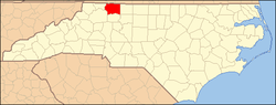 | |
| Towns | ||
| Townships | ||
| CDPs | ||
| Unincorporated communities |
| |
| Footnotes | ‡This populated place also has portions in an adjacent county or counties | |