Holly Springs, Surry County, North Carolina

Last updated
Holly Springs
USA North Carolina location map.svg
Red pog.svg
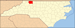
Holly Springs
Location within the state of North Carolina
Coordinates: 36°28′09″N80°32′23″W / 36.46917°N 80.53972°W / 36.46917; -80.53972 Coordinates: 36°28′09″N80°32′23″W / 36.46917°N 80.53972°W / 36.46917; -80.53972
Country United States
State North Carolina
County Surry
Elevation
1,322 ft (403 m)
Time zone UTC-5 (Eastern (EST))
  Summer (DST) UTC-4 (EDT)
ZIP codes
27030 (Mount Airy)
Area code(s) 336
GNIS feature ID2710673

Holly Springs is an unincorporated community located in the Mount Airy Township of Surry County, North Carolina, United States. The community is generally centered on the intersection of Holly Springs Road and Reeves Mill Road, southeast of Bannertown. The Mount Airy/Surry County Airport is located in Holly Springs. Other prominent landmarks include Holly Springs Baptist Church and a Bannertown Volunteer Fire Department substation.

Related Research Articles

Surry County, North Carolina County in North Carolina, United States

Surry County is a county located in the U.S. state of North Carolina. As of the 2010 census, the population was 73,673. Its county seat is Dobson, and its largest city is Mount Airy.

The Piedmont Triad is a region in the north-central part of the U.S. state of North Carolina anchored by three cities: Greensboro, Winston-Salem, and High Point. This close group of cities lies in the Piedmont geographical region of the United States and forms the basis of the Greensboro–Winston-Salem–High Point Combined Statistical Area. As of 2012, the Piedmont Triad has an estimated population of 1,611,243 making it the 33rd largest combined statistical area in the United States.

Yadkin Valley AVA

The Yadkin Valley AVA is an American Viticultural Area that includes land in seven counties of northwestern North Carolina. The AVA encompasses an area of approximately 1,400,000 acres (5,666 km2) in the Yadkin River valley. The Yadkin Valley AVA includes all of Wilkes, Surry, and Yadkin counties, and parts of Davie, Davidson, Forsyth, and Stokes counties. Yadkin Valley is home to 48 wineries.

North Carolina Highway 103 State highway in Surry County, North Carolina, US

North Carolina Highway 103 (NC 103) is a primary state highway in the U.S. state of North Carolina. It runs entirely in Surry County. It connects the city of Mount Airy with the northern end of Surry County and Virginia State Route 103 (SR 103). A 6-mile (9.7 km) segment of the highway is known as the Donna Fargo Highway, named to honor a local country music star.

North Carolina Highway 104 State highway in Surry County, North Carolina, US

North Carolina Highway 104 (NC 104) is a primary state highway in the U.S. state of North Carolina. It connects northeast Surry County with downtown Mount Airy following Riverside Drive.

<i>The Mount Airy News</i>

The Mount Airy News is a six-day-a-week newspaper published in Mount Airy, North Carolina, United States. It was established in 1880. The News has a circulation of 9,263 according to The Park Library's list of North Carolina newspapers. It is one of several newspapers serving Surry County, along with The Tribune in Elkin and The Pilot of Pilot Mountain.

Bannertown is an unincorporated community in Surry County, North Carolina, United States, just outside the city of Mount Airy. The community is centered on the intersection of Business U.S. Highway 52 and North Carolina Highway 89. Some of the area, specifically from the center of the community to the Ararat River has been annexed by Mount Airy in recent years.

Round Peak is a small unincorporated community in Surry County, North Carolina, United States, near Mount Airy, North Carolina with an elevation of 1,280 feet. It is located in the southern Appalachian Mountains and gives its name to the Round Peak style of old-time music practiced in the area.

Mount Airy Township, Surry County, North Carolina

Mount Airy Township is one of fifteen townships in Surry County, North Carolina, United States. The township had a population of 24,828 according to the 2000 census.

Westfield in an unincorporated community in Surry and Stokes counties in North Carolina, United States. The community itself is located almost entirely within Surry County, with a small portion extending east into Stokes County. The majority of Westfield's Zip Code Tabulation Area is located within Stokes County.

Sheltontown is an unincorporated community located along North Carolina Highway 89 in northeast Surry County, North Carolina, United States, near the city of Mount Airy, just east of Bannertown. The community generally lies between Rutledge Creek and the Ararat River.

Salem is an unincorporated community located in northern Surry County, North Carolina, United States on the outskirts of the city of Mount Airy. The community generally lies between Lovills Creek and the Ararat River. Prominent landmarks include Salem United Methodist Church.

White Sulphur Springs is an unincorporated community in Surry County, North Carolina, United States on the outskirts of the city of Mount Airy near the Virginia state line. The community sits on the Ararat River and once served as a popular late-nineteenth century resort. The community's name comes from the White Sulphur Springs Hotel that once stood here.

Franklin is an unincorporated community in the Mount Airy Township of Surry County, North Carolina, United States, on the outskirts of the city of Mount Airy. The community is located on South Franklin Road just south of Toast. Area landmarks include Franklin Elementary School and Franklin Volunteer Fire Department.

Oak Grove is an unincorporated community in northern Surry County, North Carolina near Bottom.

Boones Hill, North Carolina

Boones Hill is a small unincorporated community in the Mount Airy Township of northern Surry County, North Carolina, United States, on the outskirts of the city of Mount Airy near Bannertown. The community is centered on the intersection of Business U.S. Highway 52 and U.S. Highway 52 Bypass south of Bannertown. Local lore is that Daniel Boone camped on this hill.

Combstown, North Carolina

Combstown is an unincorporated community in Surry County, North Carolina, United States, located on the outskirts of the city of Mount Airy, between Bannertown and Flat Rock.

Surry Community College is a public community college in Dobson, North Carolina. Founded in 1964, it is part of the North Carolina Community College System and services Surry and Yadkin Counties.

Mount Airy/Surry County Airport

Mount Airy/Surry County Airport is a public use airport located in the unincorporated Holly Springs community three nautical miles (6 km) southeast of the central business district of Mount Airy, a city in Surry County, North Carolina, United States. The airport is owned by the city and county. It is included in the National Plan of Integrated Airport Systems for 2011–2015, which categorized it as a general aviation facility.

U.S. Route 52 (US 52) is a north–south United States highway that runs for 150 miles (240 km) from the South Carolina state line, near McFarlan, to the Virginia state line, near Mount Airy. It serves as a strategic highway through the central North Carolina Piedmont. Because of its alignment in the state, US 52 does not follow the standard convention of an even U.S. route number going east–west.

References

U.S. Geological Survey Geographic Names Information System: Holly Springs, Surry County, North Carolina