
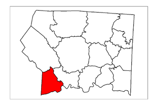
Bryan Township is one of fifteen townships in Surry County, North Carolina, United States. The township had a population of 2,766 according to the 2020 census.
Ararat is an unincorporated community in the Long Hill Township of Surry County, North Carolina, United States. Ararat is situated on, and is named for, the Ararat River. Ararat is along the former Atlantic & Yadkin Railway line from Mount Airy to Rural Hall that is now operated by the Yadkin Valley Railroad. Landmarks near the center of the community include the community post office, fire department and area churches.

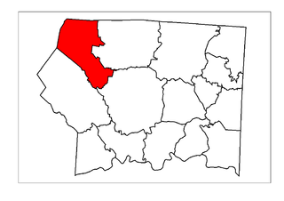
Eldora Township is one of fifteen townships in Surry County, North Carolina, United States. The township had a population of 3,659 according to the 2020 census.

Dobson Township is one of fifteen townships in Surry County, North Carolina, United States. The township had a population of 8,367 according to the 2020 census.

Mount Airy Township is one of fifteen townships in Surry County, North Carolina, United States. The township had a population of 23,750 according to the 2020 census.
Elkin Township is one of fifteen townships in Surry County, North Carolina, United States. The township had a population of 6,283 according to the 2020 census.
Franklin Township is one of fifteen townships in Surry County, North Carolina, United States. The township had a population of 2,130 according to the 2020 census. The township was named for the family of Jesse Franklin, a former governor of North Carolina and resident of the area.
Level Cross is an unincorporated community located in the Rockford Township of Surry County, North Carolina, United States.
Woodville in an unincorporated community located in the Westfield Township of northeast Surry County, North Carolina, United States, near Big Creek. The main thoroughfare through the community is North Carolina Highway 89.
Union Hill is an unincorporated community located in the Bryan Township of western Surry County, North Carolina, United States. It is located between Little Mountain and the south fork of the Mitchell River.
Slate Mountain is an unincorporated community located in northeast Surry County, North Carolina, United States between the Ararat River and Archies Creek. The community of Slate Mountain is named for the nearby summit of Slate Mountain which has an elevation 1,966 feet.
Sheltontown is an unincorporated community located along North Carolina Highway 89 in northeast Surry County, North Carolina, United States, near the city of Mount Airy, just east of Bannertown. The community generally lies between Rutledge Creek and the Ararat River.
Salem is an unincorporated community located in northern Surry County, North Carolina, United States on the outskirts of the city of Mount Airy. The community generally lies between Lovills Creek and the Ararat River. Prominent landmarks include Salem United Methodist Church.
White Sulphur Springs is an unincorporated community in Surry County, North Carolina, United States on the outskirts of the city of Mount Airy near the Virginia state line. The community sits on the Ararat River and once served as a popular late-nineteenth century resort. The community's name comes from the White Sulphur Springs Hotel that once stood here.
Ash Hill is an unincorporated community in the Eldora Township of Surry County, North Carolina, United States. The community is generally on the opposite side of the Ararat River from the community of Ararat and is roughly centered on Ararat Road between Eldora Road and Little Mountain Church Road. A school named Ash Hill was formerly located here.

Boones Hill is a small unincorporated community in the Mount Airy Township of northern Surry County, North Carolina, United States, on the outskirts of the city of Mount Airy near Bannertown. The community is centered on the intersection of Business U.S. Highway 52 and U.S. Highway 52 Bypass south of Bannertown. Local lore is that Daniel Boone camped on this hill.
Pine Hill is an unincorporated community in the Eldora Township of Surry County, North Carolina, United States. The community is centered on the intersection of Eldora Road/Quaker Church Road and North Carolina Highway 268. Prominent landmarks in the community include the Pine Hill Friends Meeting and cemetery.
Blackwater is a small Unincorporated community in the Eldora Township of Surry County, North Carolina, United States. The community is centered on the intersections of Ararat Road, Crotts Road and Siloam Road. Prominent landmarks include Blackwater Community Church, Blackwater United Methodist Church and the now defunct Blackwater Grocery.
Long Hill is a small unincorporated community in the Long Hill Township of Surry County, North Carolina. The community is centered on the intersection of Longhill Road, Ararat Road and Old U.S. Highway 52.
Crooked Oak is an unincorporated community in the Stewarts Creek Township of northern Surry County, North Carolina, United States. The community is centered on the intersection of Old Lowgap Road and Pine Ridge Road. Prominent landmarks in the community include Zion Hill Primitive Baptist Church and cemetery.

