Burch, or more commonly known locally as Burch Station, is an unincorporated community along the Yadkin River in the Marsh Township of Surry County, North Carolina, United States. The community sits on the mouth of the Mitchell River where it empties into the Yadkin. The community is known as Burch Station after the former train depot there on the former Southern Railway, now used by the Yadkin Valley Railroad.
Crutchfield is an unincorporated community along the Yadkin River in the Marsh Township of Surry County, North Carolina, United States.

Bryan Township is one of fifteen townships in Surry County, North Carolina, United States. The township had a population of 2,766 according to the 2020 census.

Eldora Township is one of fifteen townships in Surry County, North Carolina, United States. The township had a population of 3,659 according to the 2020 census.

Dobson Township is one of fifteen townships in Surry County, North Carolina, United States. The township had a population of 8,367 according to the 2020 census.

Mount Airy Township is one of fifteen townships in Surry County, North Carolina, United States. The township had a population of 23,750 according to the 2020 census.
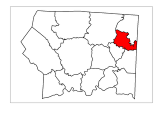
Elkin Township is one of fifteen townships in Surry County, North Carolina, United States. The township had a population of 6,283 according to the 2020 census.
Franklin Township is one of fifteen townships in Surry County, North Carolina, United States. The township had a population of 2,130 according to the 2020 census. The township was named for the family of Jesse Franklin, a former governor of North Carolina and resident of the area.

Long Hill Township is one of fifteen townships in Surry County, North Carolina, United States. The township had a population of 1,735 according to the 2020 census.

Rockford Township is one of fifteen townships in Surry County, North Carolina, United States. The township had a population of 1,745 according to the 2020 census.

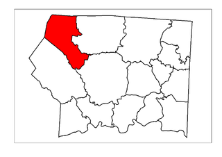
Pilot Township is one of fifteen townships in Surry County, North Carolina, United States. The township had a population of 4,085 according to the 2020 census.

Shoals Township is one of 15 townships in Surry County, North Carolina, United States. The township had a population of 1,936 according to the 2020 census.

Siloam Township is one of fifteen townships in Surry County, North Carolina, United States. The township had a population of 1,091 according to the 2020 census, making it the smallest township in Surry County by population.
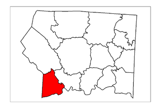
South Westfield Township is one of fifteen townships in Surry County, North Carolina, United States. The township had a population of 2,069 according to the 2020 census.

Stewarts Creek Township is one of fifteen townships in Surry County, North Carolina, United States. The township had a population of 7,000 according to the 2020 census.

Westfield Township is one of fifteen townships in Surry County, North Carolina, United States. The township had a population of 2,372 according to the 2020 census.

Cherry Lane Township is one of seven townships in Alleghany County, North Carolina, United States. The township had a population of 1,528 according to the 2010 census.
Glade Creek Township is one of seven townships in Alleghany County, North Carolina, United States. The township had a population of 1,991 according to the 2010 census.

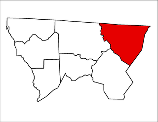
Yadkin Township is one of nine townships in Stokes County, North Carolina, United States. The township had a population of 19,592 according to the 2000 census and is by the far the largest township by population in Stokes County.

Quaker Gap Township is one of nine townships in Stokes County, North Carolina, United States.

