Boones Hill is a small unincorporated community in the Mount Airy Township of northern Surry County, North Carolina, United States, on the outskirts of the city of Mount Airy near Bannertown. The community is centered on the intersection of Business U.S. Highway 52 (South Main Street) and U.S. Highway 52 Bypass (Andy Griffith Parkway) south of Bannertown. Local lore is that Daniel Boone camped on this hill.
Municipalities and communities of Surry County, North Carolina, United States | ||
|---|---|---|
| City | 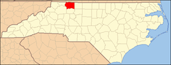 | |
| Towns | ||
| Townships | ||
| CDPs | ||
| Unincorporated communities |
| |
| Footnotes | ‡This populated place also has portions in an adjacent county or counties | |
36°28′34″N80°34′30″W / 36.476°N 80.575°W