Asomante, Aguada, Puerto Rico

Last updated
Asomante
Barrio
Asomante, Aguada, Puerto Rico locator map.png
Location of Asomante within the municipality of Aguada shown in red
Caribbean location map.svg
Red pog.svg
Asomante
Location of Puerto Rico
Coordinates: 18°23′02″N67°10′20″W / 18.383965°N 67.172313°W / 18.383965; -67.172313 [1]
Commonwealth Flag of Puerto Rico.svg  Puerto Rico
Municipality Aguada flag.png Aguada
Area
[1]
  Total1.834 sq mi (4.75 km2)
  Land1.834 sq mi (4.75 km2)
  Water0 sq mi (0 km2)
Elevation
[2]
52 ft (16 m)
Population
 (2010)
  Total3,177
  Density1,736.1/sq mi (670.3/km2)
 Source: 2010 Census
Time zone UTC−4 (AST)
ZIP Code
00602
Area code(s) 787, 939

Asomante is a barrio in the municipality of Aguada, Puerto Rico. Its population in 2010 was 3,177. [3] [4] [5]

Contents

History

Asomante was in Spain's gazetteers [6] until Puerto Rico was ceded by Spain in the aftermath of the Spanish–American War under the terms of the Treaty of Paris of 1898 and became an unincorporated territory of the United States. In 1899, the United States Department of War conducted a census of Puerto Rico finding that the combined population of Asomante barrio and Piedras Blancas barrio was 1,162. [7]

Historical population
CensusPop.Note
1910 287
1920 33416.4%
1930 42627.5%
1940 4341.9%
1950 4667.4%
1960 66743.1%
1970 0−100.0%
1980 1,914
1990 2,61336.5%
2000 3,26825.1%
2010 3,117−4.6%
U.S. Decennial Census
1900 (N/A) [8] 1910-1930 [9]
1930-1950 [10] 1960 [11] 1980-2000 [12] 2010 [13]

Sectors

Barrios (which are, in contemporary times, roughly comparable to minor civil divisions) [14] in turn are further subdivided into smaller local populated place areas/units called sectores (sectors in English). The types of sectores may vary, from normally sector to urbanización to reparto to barriada to residencial, among others.

The following sectors are in Asomante barrio: [15]

Apartamentos Portales del Navegante, Avenida Rotario, Carretera 416 (west side), Carretera 417 Norte, Carretera 417 Sur, Égida Hogar Mi Casita Feliz, Hogar María del Carmen, Parcelas Las Minas, Reparto Bonet, Residencial Aguada Gardens, Residencial Los Almendros, Sector Acevedo, Sector Brisas de Coloso, Sector Colinas del Valle, Sector Corozas, Sector Cuesta Los Chicharrones, Sector Las Guabas, Sector Los Quiñones, Sector Muñiz, Sector Vargas, Sector Vertedero, Sector Villa Alameda, Sector Villarrubia, Urbanización Los Flamboyanes, Urbanización San Francisco, Urbanización y Extensión Jardines de Aguada, and Urbanización y Extensión San José.

In Asomante barrio is part of the Aguada urban zone. [5]

Earthquakes

During the 2019-2020 Puerto Rico earthquakes the Lydia Meléndez School in Asomante served as a refuge for residents from Cerro Gordo, Las Marías and Atalaya (nearby barrios) who had to leave their damaged homes. [16]

See also

Related Research Articles

<span class="mw-page-title-main">Dagüey, Añasco, Puerto Rico</span> Barrio of Puerto Rico

Dagüey is a barrio in the municipality of Añasco, Puerto Rico. Its population in 2010 was 1,626.

<span class="mw-page-title-main">Guanajibo, Hormigueros, Puerto Rico</span> Barrio of Puerto Rico

Guanajibo is a barrio in the municipality of Hormigueros, Puerto Rico. Its population in 2010 was 5,959.

<span class="mw-page-title-main">Robles, Aibonito, Puerto Rico</span> Barrio of Puerto Rico

Robles is a barrio in the municipality of Aibonito, Puerto Rico. Its population in 2010 was 3,863.

<span class="mw-page-title-main">Llanos, Aibonito, Puerto Rico</span> Barrio of Puerto Rico

Llanos is a barrio in the municipality of Aibonito, Puerto Rico. Its population in 2010 was 6,840.

<span class="mw-page-title-main">Villalba Abajo</span> Barrio of Villalba, Puerto Rico

Villalba is a barrio in the municipality of Villalba, Puerto Rico. Its population in 2010 was 2,880.

<span class="mw-page-title-main">Aguada barrio-pueblo</span> Historical and administrative center (seat) of Aguada, Puerto Rico

Aguada barrio-pueblo is a small barrio and the administrative center (seat) of Aguada, a municipality of Puerto Rico. Its population in 2010 was 1,324. Aguada barrio-pueblo has two subdivisions: California and Rosario.

<span class="mw-page-title-main">Asomante, Aibonito, Puerto Rico</span> Barrio of Puerto Rico

Asomante is a barrio in the municipality of Aibonito, Puerto Rico. Its population in 2010 was 2,966.

<span class="mw-page-title-main">Mamey, Aguada, Puerto Rico</span> Barrio of Puerto Rico

Mamey is a barrio in the municipality of Aguada, Puerto Rico. Its population in 2010 was 2,400.

<span class="mw-page-title-main">Cerro Gordo, Aguada, Puerto Rico</span> Barrio of Puerto Rico

Cerro Gordo is a barrio in the municipality of Aguada, Puerto Rico. Its population in 2010 was 3,018.

<span class="mw-page-title-main">Atalaya, Aguada, Puerto Rico</span> Barrio of Puerto Rico

Atalaya is a barrio in the municipality of Aguada, Puerto Rico. Its population in 2010 was 3,108.

<span class="mw-page-title-main">Piedras Blancas, Aguada, Puerto Rico</span> Barrio of Puerto Rico

Piedras Blancas is a barrio in the municipality of Aguada, Puerto Rico. Its population in 2010 was 4,635.

<span class="mw-page-title-main">Rincón, Gurabo, Puerto Rico</span> Barrio of Puerto Rico

Rincón is a barrio in the municipality of Gurabo, Puerto Rico. Its population in 2010 was 10,967.

<span class="mw-page-title-main">Jagüey, Aguada, Puerto Rico</span> Barrio of Puerto Rico

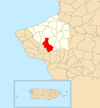
Jagüey is a barrio (county) in the municipality of Aguada, Puerto Rico. Its population in 2010 was 1,995. It is located west of the center of Aguada partly bordering the municipality of Rincón.

<span class="mw-page-title-main">Marías, Aguada, Puerto Rico</span> Barrio of Puerto Rico

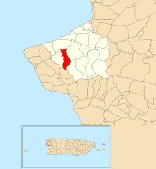
Marías is a barrio in the municipality of Aguada, Puerto Rico. Its population in 2010 was 1,997.

<span class="mw-page-title-main">Cocos, Quebradillas, Puerto Rico</span> Barrio of Puerto Rico

Cocos is a barrio in the municipality of Quebradillas, Puerto Rico. Its population in 2010 was 4,889.

<span class="mw-page-title-main">Carrizal, Aguada, Puerto Rico</span> Barrio of Puerto Rico

Carrizal is a barrio in the municipality of Aguada, Puerto Rico. Its population in 2010 was 970.

<span class="mw-page-title-main">Cruces, Aguada, Puerto Rico</span> Barrio of Puerto Rico

Cruces is a barrio in the municipality of Aguada, Puerto Rico. Its population in 2010 was 1,632.

<span class="mw-page-title-main">Guaniquilla, Aguada, Puerto Rico</span> Barrio of Puerto Rico

Guaniquilla is a coastal barrio in the municipality of Aguada, Puerto Rico. Its population in 2010 was 2,663.

<span class="mw-page-title-main">Guayabo, Aguada, Puerto Rico</span> Barrio of Puerto Rico

Guayabo is a barrio in the municipality of Aguada, Puerto Rico. Its population in 2010 was 3,273.

<span class="mw-page-title-main">Bayamón, Cidra, Puerto Rico</span> Barrio of Puerto Rico

Bayamón is a barrio in the municipality of Cidra, Puerto Rico. Its population in 2010 was 5,995.

References

  1. 1 2 "US Gazetteer". US Census. US Government.
  2. U.S. Geological Survey Geographic Names Information System: Asomante Barrio
  3. Picó, Rafael; Buitrago de Santiago, Zayda; Berrios, Hector H. Nueva geografía de Puerto Rico: física, económica, y social, por Rafael Picó. Con la colaboración de Zayda Buitrago de Santiago y Héctor H. Berrios. San Juan Editorial Universitaria, Universidad de Puerto Rico,1969.
  4. Gwillim Law (20 May 2015). Administrative Subdivisions of Countries: A Comprehensive World Reference, 1900 through 1998. McFarland. p. 300. ISBN   978-1-4766-0447-3 . Retrieved 25 December 2018.
  5. 1 2 Puerto Rico: 2010 Population and Housing Unit Counts.pdf (PDF). U.S. Dept. of Commerce, Economics and Statistics Administration, U.S. Census Bureau. 2010.
  6. "Anuario del comercio, de la industria, de la magistratura y de la administración. 1881". Biblioteca Nacional de España (in Spanish). p. 1614. Retrieved 4 April 2023.
  7. Joseph Prentiss Sanger; Henry Gannett; Walter Francis Willcox (1900). Informe sobre el censo de Puerto Rico, 1899, United States. War Dept. Porto Rico Census Office (in Spanish). Imprenta del gobierno. p.  160.
  8. "Report of the Census of Porto Rico 1899". War Department Office Director Census of Porto Rico. Archived from the original on July 16, 2017. Retrieved September 21, 2017.
  9. "Table 3-Population of Municipalities: 1930 1920 and 1910" (PDF). United States Census Bureau. Archived (PDF) from the original on August 17, 2017. Retrieved September 21, 2017.
  10. "Table 4-Area and Population of Municipalities Urban and Rural: 1930 to 1950" (PDF). United States Census Bureau. Archived (PDF) from the original on August 30, 2015. Retrieved September 21, 2014.
  11. Census of Population, 1960: Number of Inhabitants, General Population Characteristics, General Social and Economic Characteristics, and Detailed Characteristics. Characteristics of the population. U.S. Bureau of the Census. 1963. pp. 97–101. Retrieved June 10, 2023.
  12. "Table 2 Population and Housing Units: 1960 to 2000" (PDF). United States Census Bureau. Archived (PDF) from the original on July 24, 2017. Retrieved September 21, 2017.
  13. Puerto Rico: 2010 Population and Housing Unit Counts.pdf (PDF). U.S. Dept. of Commerce Economics and Statistics Administration U.S. Census Bureau. 2010. Archived (PDF) from the original on 2017-02-20. Retrieved 2019-08-02.
  14. "US Census Barrio-Pueblo definition". factfinder.com. US Census. Archived from the original on 13 May 2017. Retrieved 5 January 2019.
  15. "DESGLOSE DE SECTORES Y CENTROS DE VOTACIÓN PRECINTO ELECTORAL - AGUADA 038" (PDF). Comisión Estatal de Elecciones Puerto Rico (in Spanish). 28 October 2019. Archived from the original (PDF) on 16 June 2020. Retrieved 16 June 2020.
  16. "Estos son los daños e incidentes reportados en cada pueblo tras el poderoso terremoto de 6.4 [These are the damages and incidents reported in each town after the strong 6.4 earthquake]". El Nuevo Dia (in Spanish). 7 January 2020. Retrieved 23 June 2020.