Related Research Articles

The Jericho synagogue dates to the late 6th or early 7th century CE and was discovered in Jericho in 1936. All that remains from the ancient prayer house is its mosaic floor, which contains an Aramaic inscription presenting thanks to the synagogue donors, and a well-preserved central medallion with the inscription "Shalom al Israel", meaning "Peace [up]on Israel". This led to the site also being known as Shalom Al Israel Synagogue.

The Golan Heights, or simply the Golan, is a basaltic plateau, at the southwest corner of Syria. It is bordered by the Yarmouk River in the south, the Sea of Galilee and Hula Valley in the west, the Anti-Lebanon mountains with Mount Hermon in the north and Wadi Raqqad in the east. Two thirds of the area has been occupied by Israel following the 1967 Six-Day War and then effectively annexed in 1981 – an action unrecognized by the international community, which continues to consider it Israeli-occupied Syrian territory.

Fiq was a Syrian town in the Golan Heights that administratively belonged to Quneitra Governorate. It sat at an altitude of 349 meters (1,145 ft) and had a population of 2,800 in 1967. It was the administrative center of the Fiq District, the southern district of the Golan. Fiq was evacuated during and after the Six-Day War in June 1967. The Israeli settlement of Kibbutz Afik was built close by.

Haspin, widely known as Hispin, is a religious Israeli settlement organized as a community settlement located in the southern Golan Heights.

The Golan Archaeological Museum is a museum of the archaeological finds of the Golan Heights, located in Katzrin.

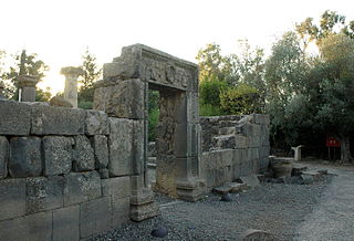
The Katzrin ancient village and synagogue (Hebrew: קצרין העתיקה; also Qasrin, Kasrin, from is an open-air museum located in the Golan Heights on the outskirts of the Israeli settlement of Katzrin. It features the partially reconstructed remains of a village from the 4th-8th century CE, that is: mainly from the Byzantine period, but starting from the Late Roman and extending into the Early Muslim era, or in Jewish historiography, the Talmudic period.

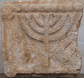
Ancient synagogues in Palestine refers to synagogues and their remains in the Land of Israel/Palestine region, built by the Jewish and Samaritan communities from the time of the Hasmonean dynasty during the Late Hellenistic period, to the Late Byzantine period.
El-Ahmediye also known as el-Hamediyeh or Ammudiya, is a former Syrian village in the central Golan Heights, 15 kilometers southeast of Lake Hula. It was populated during the Israeli occupation of the Golan Heights during the 1967 Six-Day War. The village spread over two low-lying hills surrounded by springs. The Israeli settlement of Qatzrin was established two kilometres to the south. Al-Ahmadiyah's previous inhabitants had predominantly been Turkomans.

Katzrin is an Israeli settlement organized as a local council in the Golan Heights. Known as the "capital of the Golan", it is the second-largest locality there after Majdal Shams, and the largest Israeli settlement. In 2022 it had a population of 7,876. It is the seat of Golan Regional Council.

Khirbet Almit is an archaeological site in the West Bank, occupied from the Middle Bronze Age to the Ottoman period. It is located in the Judaean Desert about 4 km northeast of Mount Scopus and about 1.5 km southeast of 'Anata. The site is situated on the top of two peaks of one hill at an altitude of 638 meters above sea level, near Nahal Zimri and on the border of the Nahal Prat Nature Reserve.
Horbat 'Uza is an archaeological site located in the Northern Coastal Plain, 8 km east of Acre, Israel. Interesting findings from the Neolithic, classical antiquity and Crusader period have been made during salvage excavations caused by the construction of a modern highway and a new railway line cutting through the site.

The Archeological Survey of Israel aims to survey the entire area of the State of Israel documenting and mapping all its archaeological sites. Executing the survey was entrusted to the Israel Antiquities Authority (IAA), as they map, measure, photograph the sites while collecting important information about them.
The Synagogue-Church at Gerasa in northwestern Jordan was originally an ancient Byzantine era synagogue that was later converted to a church. It is located within the Decapolis city of Gerasa and is situated on high ground that overlooks the Temple of Artemis at Gerasa. The synagogue is evidence of Jewish settlement in the Transjordan through late antiquity.
Roy Marom is an Israeli historian and historical geographer. Marom is the curator of the Palestinian Rural History Project, which specializes in the history of the Palestinian countryside during the Ottoman and British Mandate periods.

Ein Neshut is an archaeological site where remains of a Jewish settlement from the Talmudic period and an ancient synagogue were discovered in the center of the Golan Heights.
Ramathnia is an abandoned village in the center of the Golan Heights, about 10 kilometers east of Katzrin.

The Deir Aziz synagogue is an ancient synagogue dating from the Mishnaic and Talmudic periods, located at the archeological site of Deir Aziz, in the southern Golan Heights.

Khirbat el-Latatin is a ruin in the West Bank located about 300 meters north of the Israeli settlement of Givat Ze'ev, north west of Jerusalem, on a hill 760 meters above sea level covering an area of about four dunams.

Ein Gedi was an important Jewish settlement on the western shore of the Dead Sea in ancient times. The ruins, including the 6th century Ein Gedi synagogue, home to one of the most impressive mosaic floors in Israel, testify to a continuous Jewish settlement in the area for over 1,300 years, from the 7th century BCE to the 6th century CE.

Kfar Dvora was a Jewish settlement during the Talmudic period in the upper Gilbon River in the Golan Heights. At the site, remains of a Jewish settlement, synagogue, a Beth midrash, 5 inscriptions in Aramaic, 1 in Greek, and one in Hebrew were discovered, which was a novelty in research, as it indicated the existence of a Beth midrash in the place. Many decorated stones were also found, integrated into secondary construction and scattered in the area. On the ruins of Kfar Dvora, the Syrian village of Daburiya was established, which is currently abandoned. Before the Six-Day War, the village was inhabited by Bedouins of the Na'arna tribe, who made secondary use of the stones from the ancient Jewish settlement for construction purposes. The village is currently located northwest of the settlement of kidmat Tzvi.
References
- 1 2 3 4 5 6 7 8 "אתר הסקר הארכיאולוגי של ישראל". survey.antiquities.org.il. Retrieved 2024-09-09.
- 1 2 3 4 Shiller, Eli (1987). "אריאל : כתב עת לידיעת ארץ ישראל - רמת הגולן". www.en.kotar.co.il. Retrieved 2024-09-09.
- 1 2 Hartal, Moshe (2011). "אתר הסקר הארכיאולוגי של ישראל". survey.antiquities.org.il. Retrieved 2024-09-09.
