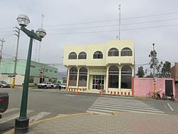
Aucallama District

Last updated
Aucallama

Awqallama
Aucallama Huaral Municipalidad.jpg
BanderaAucallama.png
Flag
EscudoAucallama.png
Coat of arms
Country Flag of Peru.svg  Peru
Region Lima
Province Huaral
Founded12 February 1821
Capital Aucallama
Government
   Mayor Hugo Aniano Alvarez Carballido
Area
  Total716.84 km2 (276.77 sq mi)
Elevation
145 m (476 ft)
Population
 (2017)
  Total19,464
  Density27/km2 (70/sq mi)
Time zone UTC-5 (PET)
UBIGEO 150604
Website www.muniaucallama.gob.pe

Aucallama District is one of twelve districts of the province Huaral in Peru. [1]

Districts of Peru third level administrative subdivision of Peru

The districts of Peru are the third-level country subdivisions of Peru. They are subdivisions of the provinces, which in turn are subdivisions of the larger regions or departments. There are 1,838 districts in total.

Huaral Province Province in Lima, Peru

The Huaral Province is one of the nine provinces in the Lima Region of Peru. It was created by Law No. 21488 on May 11, 1976 by president Francisco Morales Bermúdez out of eight districts of the Canta Province and four of the Huaura Province. Geographically, its territory extends around the valley of the Chancay River from the mountainous frontier of the Pasco Region and Junín Region up to the Pacific Ocean.

Peru republic in South America

Peru, officially the Republic of Peru, is a country in western South America. It is bordered in the north by Ecuador and Colombia, in the east by Brazil, in the southeast by Bolivia, in the south by Chile, and in the west by the Pacific Ocean. Peru is a megadiverse country with habitats ranging from the arid plains of the Pacific coastal region in the west to the peaks of the Andes mountains vertically extending from the north to the southeast of the country to the tropical Amazon Basin rainforest in the east with the Amazon river.

Related Research Articles

West Virginias 2nd congressional district

West Virginia's 2nd congressional district stretches from the Ohio River border with Ohio to the Potomac River border with Maryland and the border with Virginia. It includes the capital city of Charleston and the rapidly growing residential communities of West Virginia's Eastern Panhandle and Potomac Highlands regions connected by a narrow strip of nearly unpopulated counties. It has been accurately described as 20 miles wide and 300 miles long.

Huancas District district of Peru

Huancas is one of the 21 districts of Chachapoyas Province in the Amazonas Region of northern Peru. It is bounded to the north by Valera District, to the east by Sonche District, to the south by Chachapoyas District, and to the west by Luya District and Lámud District.

Canis District is one of fifteen districts of the province Bolognesi in Peru.

San Miguel de Corpanqui District is one of fifteen districts of the province Bolognesi in Peru.

Fresno de Río Tirón Municipality and town in Castile and León, Spain

Fresno de Río Tirón is a municipality located in the province of Burgos, Castile and León, Spain. According to the 2004 census (INE), the municipality has a population of 221 inhabitants.

São Sebastião do Rio Preto human settlement in Brazil

São Sebastião do Rio Preto is a Brazilian municipality located in the state of Minas Gerais. The city belongs to the mesoregion Metropolitana de Belo Horizonte and to the microregion of Conceição do Mato Dentro.

Caleta de Carquin District is one of twelve districts of the province Huaura in Peru.

Alfonso Ugarte District is one of ten districts of the province Sihuas in Peru.

Chingalpo District is one of ten districts of the province Sihuas in Peru.

Quiches District is one of ten districts of the province Sihuas in Peru.

Cajamarquilla District District in Ancash, Peru

Cajamarquilla District is one of ten districts of the province Ocros in Peru.

Cochas District, Ocros District in Ancash, Peru

Cochas District is one of ten districts of the province Ocros in Peru.

Corongo District is one of seven districts of the province Corongo in Peru.

Yupan District is one of seven districts of the province Corongo in Peru.

Ora, Indiana Unincorporated community in Indiana, United States

Ora is an unincorporated community in southern North Bend Township, Starke County, in the U.S. state of Indiana.

Iguatama Brazilian municipality located in the west of the state of Minas Gerais

Iguatama is a Brazilian municipality located in the west of the state of Minas Gerais. Its population as of 2007 was 7,632 people living in a total area of 627 km². The city belongs to the meso-region of Oeste de Minas and to the micro-region of Piumhi. It became a municipality in 1944.

João Monlevade municipality of Brazil

João Monlevade is a Brazilian municipality located in the state of Minas Gerais. The city belongs to the mesoregion Metropolitana de Belo Horizonte and to the microregion of Itabira.

Rio Piracicaba

Rio Piracicaba is a Brazilian municipality located in the state of Minas Gerais. The city belongs to the mesoregion Metropolitana de Belo Horizonte and to the microregion of Itabira. It has two rural districts: Conceição de Piracicaba and Padre Pinto.

Cidelândia is a municipality in the state of Maranhão in the Northeast region of Brazil.

Poythress Estates is an unincorporated community located in Brunswick County, in the U.S. state of Virginia.

References

Coordinates: 11°33′56″S77°10′26″W / 11.56556°S 77.17389°W / -11.56556; -77.17389

Geographic coordinate system Coordinate system

A geographic coordinate system is a coordinate system that enables every location on Earth to be specified by a set of numbers, letters or symbols. The coordinates are often chosen such that one of the numbers represents a vertical position and two or three of the numbers represent a horizontal position; alternatively, a geographic position may be expressed in a combined three-dimensional Cartesian vector. A common choice of coordinates is latitude, longitude and elevation. To specify a location on a plane requires a map projection.