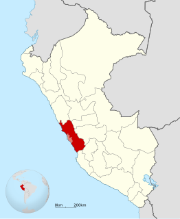
Antioquia District

Last updated
Antioquia
Plaza de armas antioquia.JPG
Plaza of the town of Antioquia
Country Flag of Peru.svg  Peru
Region Lima
Province Huarochirí
FoundedApril 5, 1935
Capital Espiritu Santo
Government
   Mayor Luis Hilibrando Ramos
(2019-2022)
Area
  Total387.98 km2 (149.80 sq mi)
Elevation
1,526 m (5,007 ft)
Population
(2017)
  Total1,225
  Density3.5/km2 (9/sq mi)
Time zone UTC-5 (PET)
UBIGEO 150702
Website Official website

Antioquia District is one of thirty-two districts of the province Huarochirí in Peru. [1]

Districts of Peru third level administrative subdivision of Peru

The districts of Peru are the third-level country subdivisions of Peru. They are subdivisions of the provinces, which in turn are subdivisions of the larger regions or departments. There are 1,838 districts in total.

Huarochirí Province Province in Lima, Peru

Huarochirí Province or Waruchiri is located in the Lima Region of Peru. Its capital is Matucana. The western section is part of the Lima Metropolitan Area.

Peru republic in South America

Peru, officially the Republic of Peru, is a country in western South America. It is bordered in the north by Ecuador and Colombia, in the east by Brazil, in the southeast by Bolivia, in the south by Chile, and in the west by the Pacific Ocean. Peru is a megadiverse country with habitats ranging from the arid plains of the Pacific coastal region in the west to the peaks of the Andes mountains vertically extending from the north to the southeast of the country to the tropical Amazon Basin rainforest in the east with the Amazon river.

Contents

Demography

The population (2017 census) of the district is 1,225 people. [2]

The 2017 Peru Census was a detailed enumeration and twelfth national population census of Peru. It was conducted by the Instituto Nacional de Estadística e Informática on Sunday, October 22, 2017. Its full name in Spanish is XII Censo de Población, VII de Vivienda y III de Comunidades Indígenas. The previous census performed in Peru was the 2007 Census.

Populated areas

NameClassHomesPopulation
AntioquiaUrban171337
CochahuaycoRural165170
OtherRural626869

Tourism

The town is colored in an altarpiece style. [3]

Some places people visit are:

Also there are camping zones and canaveral extensions. There are ruins of the ancient Capac Ñam (an old Inca road system).

Camping outdoor recreational activity

Camping is an outdoor activity involving overnight stays away from home in a shelter, such as a tent. Typically participants leave developed areas to spend time outdoors in more natural ones in pursuit of activities providing them enjoyment. To be regarded as "camping" a minimum of one night is spent outdoors, distinguishing it from day-tripping, picnicking, and other similarly short-term recreational activities. Camping can be enjoyed through all four seasons.

Inca road system Transportation system of the Inca empire

The Inca road system was the most extensive and advanced transportation system in pre-Columbian South America. It was about 39,900 kilometres (24,800 mi) long. The construction of the roads required a large expenditure of time and effort. The network was based on two north-south roads with numerous branches. The best known portion of the road system is the Inca Trail to Machu Picchu. Part of the road network was built by cultures that precede the Inca Empire, notably the Wari culture. During the Spanish colonial era, parts of the road system were given the status of Camino Real. In 2014 the road system became a UNESCO World Heritage Site.

See also

Lima Region Region in 10 provinces and 171 districts, Peru

The Lima Region is located in the central coast of the country. Its capital and most populated city is the homonymous Lima. The province of Lima has a special autonomy regime in regional affairs, and the rest of the provinces are governed from the city of Huacho, seat of the Regional Government.

Administrative divisions of Peru administrative subdivision of Peru

The administrative divisions of Peru have changed from time to time, since the nation gained independence from Spain in the early 19th century. The old territorial subdivisions have split or merged due to several reasons, the most common ones being the need for decentralization, and population increase, especially in Lima.

Related Research Articles

Aczo District is one of six districts of the province Antonio Raymondi in Peru.

Quinua District is one of fifteen districts of the province Huamanga in Peru.

Lahuaytambo District is one of thirty-two districts of the province Huarochirí in Peru.

San Andrés de Tupicocha District is one of thirty-two districts of the province Huarochirí in Peru.

San Pedro de Huancayre District is one of thirty-two districts of the province Huarochirí in Peru.

Sangallaya District is one of thirty-two districts of the province Huarochirí in Peru.

Santo Domingo de los Olleros District is one of thirty-two districts of the province Huarochirí in Peru.

Chuquis District is one of nine districts of the province Dos de Mayo in Peru.

Chavín de Pariarca District District in Huánuco, Peru

Chavín de Pariarca District is one of eleven districts of the province Huamalíes in Peru.

Miraflores District, Huamalíes District in Huánuco, Peru

Miraflores District is one of eleven districts of the province Huamalíes in Peru.

Puños District is one of eleven districts of the province Huamalíes in Peru.

Margos District is one of twelve districts of the province Huánuco in Peru.

Molino District is one of four districts of the province Pachitea in Peru.

Chavinillo District District in Huánuco, Peru

Chavinillo District is one of eight districts of the province Yarowilca in Peru.

Choras District is one of eight districts of the province Yarowilca in Peru.

Obas District is one of eight districts of the province Yarowilca in Peru.

Anra District is one of sixteen districts of the province Huari in Peru.

Huacachi District is one of sixteen districts of the province Huari Province in the Ancash Region of Peru.

Ponto District is one of sixteen districts of the province Huari in Peru.

Rapayan District is one of sixteen districts of the province Huari in Peru.

References

Coordinates: 12°04′50.6″S76°30′38.2″W / 12.080722°S 76.510611°W / -12.080722; -76.510611

Geographic coordinate system Coordinate system

A geographic coordinate system is a coordinate system that enables every location on Earth to be specified by a set of numbers, letters or symbols. The coordinates are often chosen such that one of the numbers represents a vertical position and two or three of the numbers represent a horizontal position; alternatively, a geographic position may be expressed in a combined three-dimensional Cartesian vector. A common choice of coordinates is latitude, longitude and elevation. To specify a location on a plane requires a map projection.