Franklin Township is a township in Huntingdon County, Pennsylvania, United States. The population was 499 at the 2020 census.

Hedmark was a county in Norway before 1 January 2020, bordering Trøndelag to the north, Oppland to the west, Akershus to the south, and Sweden to the east. The county administration is in Hamar.
Abelardo Pardo Lezameta District is one of fifteen districts of the province Bolognesi in Peru.
Canis District is one of fifteen districts of the province Bolognesi in Peru.
San Miguel de Corpanqui District is one of fifteen districts of the province Bolognesi in Peru.
San Miguel de Acos District is one of twelve districts of the province Huaral in Peru.
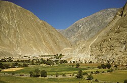
Pararin District is one of ten districts of the Recuay Province in Peru.

San Luis District is one of three districts of the province Carlos Fermín Fitzcarrald in Peru.
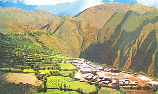
Huachis District is one of sixteen districts of the Huari Province in the Ancash Region in Peru.
Masin District is one of sixteen districts of the Huari Province in Peru.
Llipa District is one of ten districts of the Ocros Province in Peru.

Eleazar Guzmán Barrón District is one of eight districts of the Mariscal Luzuriaga Province in Peru.
Fidel Olivas Escudero District is one of eight districts of the Mariscal Luzuriaga Province in Peru.

Llama District is one of eight districts of the Mariscal Luzuriaga Province in Peru.

Llumpa District is one of eight districts of the Mariscal Luzuriaga Province in Peru. This district was created by Law, dated at October 28, 1889, president of Perou: Andrés A. Cáceres
Musga District is one of eight districts of the Mariscal Luzuriaga Province in Peru.
Matacoto District is one of eight districts of the Yungay Province in Peru.
Ranrahirca District is one of eight districts of the Yungay Province in Peru.

Sacramento National Forest is a former National Forest in southern New Mexico. The Forest was established by Presidential proclamation on April 24, 1907 to preserve the timber-rich lands in the southern Sacramento Mountains around Cloudcroft and Mayhill. Led by inaugural Forest Supervisor C. H. Hinderer, the forest was headquartered in Alamogordo. Fourteen months later, on July 2, 1908, President Roosevelt issued Executive Order 908. which consolidated the Sacramento with the nearby Guadalupe National Forest to create the Alamo National Forest. Arthur M. Neal, the last supervisor of the independent Guadalupe forest became the initial supervisor for the new Alamo National Forest, with his headquarters in Alamogordo. Under this new administrative scheme the former Sacramento National Forest was divided into a number of individual Ranger Districts within the Alamo National Forest, including Fresnal, La Luz, Mayhill, and Weed. On June 6, 1917, President Woodrow Wilson issued Executive Order 2633, which disestablished the Alamo National Forest and transferred all of its lands to the nearby Lincoln National Forest. As a result of this order, some areas of the former Sacramento National Forest, like La Luz Ranger District, lost their independent status, others were renamed, such as the Fresnal district, which became the Cloudcroft Ranger District, and others, like Mayhill and Weed, retained their original names and designations. In 1961, the Cloudcroft, Mayhill and Weed Ranger Districts were consolidated and given their current designation, the Sacramento Ranger District of the Lincoln National Forest.

Fimbulheimen is a mountain range in Queen Maud Land, Antarctica. It stretches from Jutulstraumen by 1° west of Carsten Borchgrevink Ice at 18° east, about 200 km from the ice edge. Fimbulheimen is thus between Maudheim Plateau and Sør-Rondane.