
Briar Creek Township is a township in Columbia County, Pennsylvania, United States. The population was 3,016 at the 2010 census.
Metauten is a town and municipality located in the province and autonomous community of Navarre, northern Spain.

Vashon Island High School (VHS) is a public high school located on Vashon Island, Washington. Vashon Island High School, a part of the Vashon Island School District, is the only high school to serve the island. VHS runs 9th through 12th grade. The school has two language courses available: Japanese and Spanish. VHS puts on three plays a year within the three drama classes; Theater Arts I, II and Musical Theater. VHS also has a band which puts on three concerts, including a Christmas concert and a Pops concert. The band also competes at a band competition at Stadium High School. The school's athletic mascot is the Pirates. Currently VHS has an enrollment of 518 students and 44 faculty and staff.

Corn Ranch is a spaceport in the West Texas town of Van Horn, Texas, where flight tests of the New Shepard are carried out by Blue Origin. The 165,000-acre (670 km²) land parcel was purchased by Internet billionaire Jeff Bezos. The first flight test took place on November 13, 2006 with the goal of providing commercial tourist flights.
Igreja Nova is a municipality located in the south of the Brazilian state of Alagoas. Its population is 22,455 (2005) and its area is 429 km².

Opa-locka West Airport was a county-owned public airport located 12 miles (19 km) northwest of the central business district of Miami, a city in Miami-Dade County, Florida, United States. It covered an area of 420 acres (170 ha) which contained two asphalt paved runways: 9/27 measuring 3,000 x 60 ft and 18/36 measuring 3,000 x 60 ft.
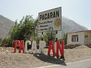
Pacarán District is one of sixteen districts of the province Cañete in Peru.
Santa Cruz de Flores District is one of sixteen districts of the province Cañete in Peru.
San Pedro de Huancayre District is one of thirty-two districts of the province Huarochirí in Peru.
Santo Domingo de los Olleros District is one of thirty-two districts of the province Huarochirí in Peru.

San Pedro de Pilas District is one of thirty-three districts of the province Yauyos in Peru.
Quilca District is one of eight districts of the province Camaná in Peru.

Majówka is a village in the administrative district of Gmina Supraśl, within Białystok County, Podlaskie Voivodeship, in north-eastern Poland. It lies approximately 11 kilometres (7 mi) south of Supraśl and 12 km (7 mi) east of the regional capital Białystok.
Wołyńce-Kolonia is a village in the administrative district of Gmina Siedlce, within Siedlce County, Masovian Voivodeship, in east-central Poland.
Kazubek is a village in the administrative district of Gmina Wierzbinek, within Konin County, Greater Poland Voivodeship, in west-central Poland.
Meter is an unincorporated community in Westmoreland County, Virginia, United States.

Harvie Heights is a hamlet in Alberta, Canada within the Municipal District of Bighorn No. 8. It is located within Alberta's Rockies on the Trans-Canada Highway approximately 4 kilometres (2.5 mi) northwest of Canmore and immediately east of the park gate for Banff National Park.
Tall-e Shureh is a village in Jereh Rural District, Jereh and Baladeh District, Kazerun County, Fars Province, Iran. At the 2006 census, its population was 206, in 45 families.
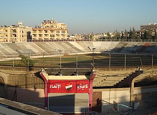
Al-Ittihad Stadium is a football stadium in Aleppo, Syria. It is owned by the Aleppo-based al-Ittihad SC and has a capacity of 10,000 spectators.

Wamanripa is a mountainous complex in the Wansu mountain range in the Andes of Peru, about 5,300 metres (17,388 ft) high. It is situated in the Cusco Region, Chumbivilcas Province, Santo Tomás District. Wamanripa lies southeast of the mountain Chankuwaña and east of the mountains Waytani and Uturunku.


