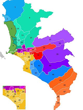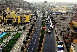
Lima, founded in 1535 as the Ciudad de los Reyes, is the capital and largest city of Peru. It is located in the valleys of the Chillón, Rímac and Lurín Rivers, in the desert zone of the central coastal part of the country, overlooking the Pacific Ocean. The city is considered the political, cultural, financial and commercial center of Peru. Due to its geostrategic importance, the Globalization and World Cities Research Network has categorized it as a "beta" tier city. Jurisdictionally, the metropolis extends mainly within the province of Lima and in a smaller portion, to the west, within the Constitutional Province of Callao, where the seaport and the Jorge Chávez Airport are located. Both provinces have regional autonomy since 2002.

Pueblos jóvenes is the term used for the shanty towns that surround Lima and other cities of Peru. Many of these towns have developed into districts of Lima such as Comas, Los Olivos and Villa El Salvador.

Lima is a district of Lima Province in Peru. Lima district is the oldest in Lima Province and as such, vestiges of the city's colonial era remain today in the historic centre of Lima, which was declared a UNESCO World Heritage Site in 1988 and contains the foundational area known as Cercado de Lima.
The Rímac River is located in western Peru and is the most important source of potable water for the Lima and Callao Metropolitan Area. It belongs to the Pacific Slope, into which it flows after bathing the cities of Lima and Callao, together with the Chillón River, to the north, and the Lurín River, to the south. It is 204 km long and has a basin of 3,312 km², of which 2,237.2 km² is a humid basin. The basin has a total of 191 lagoons, of which only 89 have been studied. The river begins in the highlands of the Huarochirí Province in the Lima Region and its mouth is located in Callao, near Jorge Chávez International Airport.

The Lima Metropolitan Area is an area formed by the conurbation of the Peruvian provinces of Lima and Callao. It is the largest of the metropolitan areas of Peru, the seventh largest in the Americas, the fourth largest in Latin America, and among the thirty largest in the world. The conurbation process started to be evident in the 1980s.

Rímac, known until the 19th century as the neighbourhood of San Lázaro, is a district in the Lima Province, Peru. It lies directly to the north of downtown Lima, to which it is connected by six bridges over the Rímac River. The district also borders the Independencia, San Martín de Porres, and San Juan de Lurigancho districts. Vestiges of Lima's colonial heyday remain today in an area of the Rímac district known as the Historic centre of Lima, which was declared a UNESCO World Heritage Site in 1988. Downtown Rímac District has, like its southern counterpart, its eastern and western sides divided by Jirón Trujillo, which connects to Lima District's Jirón de la Unión through the Puente de Piedra, the oldest bridge in the whole city. Rímac's East side features the Plaza de Acho, the most famous bullfighting arena in South America and one of the most well known in the world.

San Martín de Porres (SMP) is a district in Lima, Peru, located in the north area of the city. It is bordered by the Chillón River, marks its natural border with Ventanilla and Puente Piedra on the north; Callao on the west; Los Olivos, Comas on the northeast; Rímac and Independencia districts on the east; the Rímac River marks its natural border with Lima District and Carmen de la Legua Reynoso on the south. It is the second most populated district of Lima metropolitan area and Peru.

San Juan de Lurigancho (SJL) is a district in Lima, Peru, located in the area known as Cono Este. It is Peru's most populous district, with a current population that may exceed one million.

The district of La Victoria is one of the forty-three districts that make up the province of Lima, located in Peru. It borders to the north and northeast with the district of Lima, to the east with the district of San Luis, to the southeast with the district of San Borja, to the south with the district of San Isidro, and to the west with the district of Lince and again with the Lima district. La Victoria is a historical and very busy public district located in downtown Lima. The current mayor of La Victoria is Rubén Dioscorides Andrés Cano Altez.

Chaclacayo is a district of the Lima Province in Peru. Together with Chosica, Chaclacayo is the natural exit district to Central Peru, east of Lima, through the Carretera Central.

The Ate district, also called Ate-Vitarte, is one of the forty-three districts that make up the Lima Province, located in Peru.

Lurigancho-Chosica is a district of Lima Province, Peru, located in the valley of the Rímac River, which it shares with neighboring Chaclacayo and Ate districts. Its capital is the town of Chosica. Its administrative center is located 861 m (2,825 ft) above sea level.

El Agustino is a district of the Lima Province in Peru. It is part of city of Lima. Officially established as a district on January 6, 1965. The current mayor (alcalde) of El Agustino is Richard Robert Soria Fuerte. The district's postal code is 10.
A Peruvian postal code is a five-digit string that comprises part of a postal address in Peru. Prior to 2011, only the major cities of Lima and Callao used postal codes. However, in February 2011 a nationwide system was implemented which employs a five-digit numeric format. Similar to the postal codes of Mexico, Brazil, Australia, the United States, and elsewhere, postal codes in Peru are strictly numerical, using only numbers.

Carabayllo is one of the 43 districts of the province Lima in Peru. It is located in the Cono Norte area of the province and was created district by General José de San Martín in August 4, 1821 at which time it was the only district to occupy the area north of the Rímac River up to the province Canta.

Huarochirí Province or Waruchiri is located in the Lima Region of Peru. Its capital is Matucana. The western section is part of the Lima Metropolitan Area.
Comunidad Cristiana Agua Viva is a charismatic evangelical megachurch in Lima, Peru. As of 2017, it has seven locations in Lima Province.
Delia Rosa Zamudio Palacios is an Afro-Peruvian trade unionist and leader in the activism for the rights of Afro-Peruvian women. She was the first woman to become the head of the General Confederation of Workers of Peru. She has worked since the 1970s to improve the human and civil rights of Afro-Peruvians and working women. As a founder of the Casa de Refugio San Juan de Lurigancho she has worked to assist victims of domestic and sexual violence. She was recognized by the Ministry of Culture for her contributions with the Meritorious Personality of Culture Award in 2014.

Antonio Huachaca was a Peruvian indigenous peasant and loyalist of the Spanish Empire who fought for Spain during the Viceregal era, and then for the Royalist cause during and after the Peruvian War of Independence, reaching the rank of brigadier general of the Royal Army of Peru. He later took part in establishing the Peru–Bolivian Confederation, eventually holding the title of "Justice of the Peace and Governor of Carhuaucran District" until the Confederation's dissolution in 1839.

The Battle of San Jerónimo was the first battle of the Breña campaign of the War of the Pacific between April 9 and 11, 1881. The battle was fought between the newly formed Peruvian guerillas commanded by Colonel José Agustín Bedoya which were defending the town of San Jerónimo within the Department of Lima against the Chilean occupation force commanded by General José Miguel Alcérreca.


