Barranca District, Barranca

Last updated
Barranca
Country Flag of Peru.svg  Peru
Region Lima
Province Barranca
Capital Barranca
Government
   Mayor Ricardo Zender
(2019-2022)
Area
  Total153.76 km2 (59.37 sq mi)
Elevation
49 m (161 ft)
Population
(2017)
  Total68,324
  Density440/km2 (1,200/sq mi)
Time zone UTC-5 (PET)
UBIGEO 150201

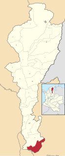
Barranca District is one of five districts of the province Barranca in Peru. [1]

Districts of Peru third level administrative subdivision of Peru

The districts of Peru are the third-level country subdivisions of Peru. They are subdivisions of the provinces, which in turn are subdivisions of the larger regions or departments. There are 1,838 districts in total.

Barranca Province Province in Lima, Peru

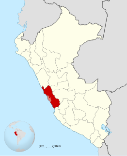
The Barranca Province is one of the nine provinces in the Lima Region of Peru. It was created by Law No. 23939 on October 5, 1984 by the government of President Fernando Belaunde Terry. Geographically, the province has a flat terrain crossed by the valleys of the rivers Fortaleza, Pativilca and Supe.

Peru republic in South America

Peru, officially the Republic of Peru, is a country in western South America. It is bordered in the north by Ecuador and Colombia, in the east by Brazil, in the southeast by Bolivia, in the south by Chile, and in the west by the Pacific Ocean. Peru is a megadiverse country with habitats ranging from the arid plains of the Pacific coastal region in the west to the peaks of the Andes mountains vertically extending from the north to the southeast of the country to the tropical Amazon Basin rainforest in the east with the Amazon river.

Related Research Articles

Huacho Town in Lima, Peru

Huacho is a city in Peru, capital of the Huaura Province and capital of the Lima Region. It is located 223 feet above sea level and 148 km north of the city of Lima. The city is located on the Pan-American Highway and it is close to the Lachay National Reserve, so it has extensive vegetation and wildlife.

Department of Lima Region in 10 provinces and 171 districts, Peru

The Department of Lima is located in the central coast of the country, its regional seat is Huacho. Lima Province, which contains the city of Lima, the country's capital, is located west of the Lima Region; this province is autonomous and not under the jurisdiction of the Regional Government.

Corosha District is one of twelve districts of the province Bongará in Peru.

San Alberto, Cesar town in Caribbean, Colombia

San Alberto is a town and municipality in the Colombian Department of Cesar.

Barrancas, La Guajira town in Caribbean, Colombia

Barrancas is a town and municipality of the Colombian Department of La Guajira. The municipality of Barrancas is located to the left margin of the Ranchería River in a valley formed between the Sierra Nevada de Santa Marta mountains and the Serranía del Perijá. Barrancas has a total area of 742 km² and at 40 meters over sea level. The average temperature is 28°C throughout the year and distances from the capital of the Department of La Guajira, Riohacha. It became a municipality in 1892.

Pativilca is one of five districts of the province Barranca in Peru.

The Oxford-Man Institute of Quantitative Finance is an interdisciplinary research institute of the University of Oxford, England. The Institute was co-founded in June 2007 with Man Group plc. It brings together faculty, post-docs and students throughout the University interested in research into the quantitative finance applications of machine learning and data analytics.

Pativilca Town in Lima, Peru

Pativilca is a town in central Peru, capital of the district Pativilca in the province Barranca in the region Lima.

Barranca, Lima Place in Lima, Peru

Barranca is a city in central Peru, capital of the province Barranca in the region Lima.

Paramonga District District in Lima, Peru

Paramonga District is one of five districts of the province Barranca in Peru.

Supe Puerto District is one of five districts of the province Barranca in Peru.

Copa District is one of five districts of the province Cajatambo in Peru.

Cochamarca is one of six districts of the Oyón Province in Peru.

Ambar District is one of twelve districts of the province Huaura in Peru.

Barranca District is one of six districts of the province Datem del Marañón in Peru.

La Libertad District is one of twelve districts of the province Huaraz in Peru.

Cajamarquilla District District in Ancash, Peru

Cajamarquilla District is one of ten districts of the province Ocros in Peru.

Musga District is one of eight districts of the province Mariscal Luzuriaga in Peru.

Paramonga, Peru Town in Lima, Peru

Paramonga is a town in central Peru, capital of the district of Paramonga in the province of Barranca in the Lima Region.

References

Coordinates: 10°45′09″S77°45′41″W / 10.7525°S 77.7615°W / -10.7525; -77.7615

Geographic coordinate system Coordinate system

A geographic coordinate system is a coordinate system that enables every location on Earth to be specified by a set of numbers, letters or symbols. The coordinates are often chosen such that one of the numbers represents a vertical position and two or three of the numbers represent a horizontal position; alternatively, a geographic position may be expressed in a combined three-dimensional Cartesian vector. A common choice of coordinates is latitude, longitude and elevation. To specify a location on a plane requires a map projection.