
Lower Allen Township is a township in Cumberland County, Pennsylvania, United States. The population was 17,980 at the 2010 census.

Mahanoy City is a borough located 38 miles (61 km) southwest of Wilkes-Barre and 13 miles southwest of Hazleton, in northern Schuylkill County, Pennsylvania in the southern Coal Region. It is located entirely within but is not part of Mahanoy Township. The name "Mahanoy" is believed to be a variation of the Native American word 'Maghonioy', or "the salt deposits".

White Deer Township is a township in Union County, Pennsylvania, United States. The population was 4,273 at the 2000 census.

Peace Valley is a small unincorporated community in eastern Howell County, Missouri, United States. It is about two miles east of Route 17 on Route W.

Klay District is one of four districts of Bomi County, Liberia. As of 2008 the population was 22,355.
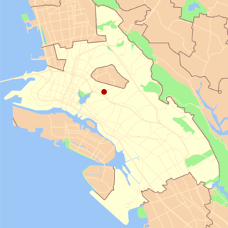
Trestle Glen is a neighborhood in Oakland, California. It is located east of Lakeshore Avenue, a shopping street which it shares with the Grand Lake District. It lies at an elevation of 144 feet. The streets are laid out in the curvilinear pattern of early 20th century garden suburbs. Many of the houses are nestled in the surrounding hills, and were built shortly before The Great Depression. The neighborhood is named after a railroad trestle built in 1893, which was dismantled in 1906 when the line was rerouted. The railroad line ran along Trestle Glen Creek, which was named Indian Gulch by early settlers after the Huchiun village that was located near the present-day intersection of Lakeshore and Trestle Glen Road. The streetcar was instrumental in spurring the development of residential neighborhoods in the area. It is often written that Mark Twain was a passenger on the maiden voyage of the streetcar, though Twain lived in Europe at the time.

DeSabla is an unincorporated community in Butte County, California. It lies at an elevation of 2762 feet. It was named after one of the Pacific Gas and Electric founders and is the site of Lake de Sabla reservoir and a powerhouse named for him. The community's ZIP code is 95954, and is shared with the community of Magalia. The area code is 530. NAD27 latitude and longitude for the community are 39°52′26″N121°36′06″W and official elevation is 2,780 feet (850 m) above mean sea level.
Namal, is a town and union council, an administrative subdivision, of Mianwali District in the Punjab province of Pakistan. It is part of Mianwali Tehsil and is located at 32°40'10N 71°48'45E.
Callaghan is a ranching community in Webb County, Texas and was established in 1881. The community was named after a nearby ranch owned by Charles Callaghan and much later Joe B. Finley. The community was once a cattle shipping point on the International and Great Northern Railroad. Callaghan is served by the Callaghan Ranch Airport. Callaghan is fourteen miles north of Laredo, Texas.

Kolonia Dębina is a settlement in the administrative district of Gmina Wolbórz, within Piotrków County, Łódź Voivodeship, in central Poland. It lies approximately 4 kilometres (2 mi) south-east of Wolbórz, 17 km (11 mi) north-east of Piotrków Trybunalski, and 44 km (27 mi) south-east of the regional capital Łódź.
Budy Polskie is a village in the administrative district of Gmina Strzegowo, within Mława County, Masovian Voivodeship, in east-central Poland.
Bukowa Góra is a settlement in the administrative district of Gmina Czersk, within Chojnice County, Pomeranian Voivodeship, in northern Poland.
Wozławki is a village in the administrative district of Gmina Bisztynek, within Bartoszyce County, Warmian-Masurian Voivodeship, in northern Poland. It lies approximately 7 kilometres (4 mi) north of Bisztynek, 16 km (10 mi) south of Bartoszyce, and 45 km (28 mi) north-east of the regional capital Olsztyn.
Rejczuchy is a village in the administrative district of Gmina Barczewo, within Olsztyn County, Warmian-Masurian Voivodeship, in northern Poland.
Łąkówko is a settlement in the administrative district of Gmina Połczyn-Zdrój, within Świdwin County, West Pomeranian Voivodeship, in north-western Poland. It lies approximately 12 kilometres (7 mi) north of Połczyn-Zdrój, 25 km (16 mi) north-east of Świdwin, and 113 km (70 mi) north-east of the regional capital Szczecin.
Irish Town is an unincorporated community in Butte County, California. It lies at an elevation of 2,270 feet.
Collège Bart is a private college in Quebec City, Quebec, Canada. The school was founded in 1917 by Jean-Baptiste Bart, a teacher who emigrated from France. Bart's son Jean-Guy Bart became one of the leaders of the college. The current directors are Michel Bellerose and Johanne Renauld.

Cunot is an unincorporated community in Jackson Township, Owen County, in the U.S. state of Indiana. It lies near the intersection of Indiana Highway 42 and Indiana Highway 243, which is a community about twenty miles north of the city of Spencer, the county seat of Owen County. Its elevation is 722 feet, and it is located at 39°27′23″N86°51′17″W. Although this community is located within Owen County on its northern boundary, it has an address of Cloverdale, Indiana in Putnam County, which is about six miles northeast of the community.
Farmers is an unincorporated community in the southwest corner of Franklin Township, Owen County, in the U.S. state of Indiana. It lies just south of US Highway 231 at the intersection of 650 West, which is a community about twelve miles south of the city of Spencer, the county seat of Owen County. Its elevation is 591 feet, and it is located at 39°10′31″N86°53′30″W. This community is also known as Farmers Station.

Altamont Switch is an unincorporated community in Wea Township, Tippecanoe County, in the U.S. state of Indiana.


