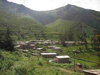
Cuenca District, Huarochirí

Last updated
Cuenca District
Country Flag of Peru.svg  Peru
Region Lima
Province Huarochirí
FoundedApril 5, 1935
Capital San José de los Chorillos
Government
   Mayor Linder Yanavilca Cuellar
(2019-2022)
Area
  Total60.02 km2 (23.17 sq mi)
Elevation
2,780 m (9,120 ft)
Population
(2017)
  Total449
  Density7.5/km2 (19/sq mi)
Time zone UTC-5 (PET)
UBIGEO 150706

Cuenca District is one of thirty-two districts of the province Huarochirí in Peru. [1]

Districts of Peru third level administrative subdivision of Peru

The districts of Peru are the third-level country subdivisions of Peru. They are subdivisions of the provinces, which in turn are subdivisions of the larger regions or departments. There are 1,838 districts in total.

Huarochirí Province Province in Lima, Peru

Huarochirí Province or Waruchiri is located in the Lima Region of Peru. Its capital is Matucana. The western section is part of the Lima Metropolitan Area.

Peru republic in South America

Peru, officially the Republic of Peru, is a country in western South America. It is bordered in the north by Ecuador and Colombia, in the east by Brazil, in the southeast by Bolivia, in the south by Chile, and in the west by the Pacific Ocean. Peru is a megadiverse country with habitats ranging from the arid plains of the Pacific coastal region in the west to the peaks of the Andes mountains vertically extending from the north to the southeast of the country to the tropical Amazon Basin rainforest in the east with the Amazon river.

Related Research Articles

Larchmont is a neighborhood of single family residences located in Houston. It is located between Richmond Avenue and Interstate 69/U.S. Route 59.

Calango District District in Lima, Peru

Calango District is one of sixteen districts of the province Cañete in Peru.

Chilca District is one of sixteen districts of the province Cañete in Peru.

Coayllo District District in Lima, Peru

Coayllo District is one of sixteen districts of the province Cañete in Peru.

Callahuanca District is one of thirty-two districts of the province Huarochirí in Peru.

Chicla District District in Lima, Peru

Chicla District is one of thirty-two districts of the province Huarochirí in Peru.

Langa District is one of thirty-two districts of the province Huarochirí in Peru.

San Juan de Tantaranche District is one of thirty-two districts of the province Huarochirí in Peru.

San Andrés de Tupicocha District is one of thirty-two districts of the province Huarochirí in Peru.

San Pedro de Huancayre District is one of thirty-two districts of the province Huarochirí in Peru.

Ayauca District is one of thirty-three districts of the province Yauyos in Peru.

Cochas District is one of thirty-three districts of the province Yauyos in Peru.

Quinches District District in Lima, Peru

Quinches District is one of thirty-three districts of the province Yauyos in Peru.

Quinocay District District in Lima, Peru

Quinocay District is one of thirty-three districts of the province Yauyos in Peru.

Tanta District is one of thirty-three districts of the province Yauyos in Peru. Its seat is the village Tanta.

Shamboyacu District is one of ten districts of the province Picota in Peru.

Caynarachi District is one of eleven districts of the province Lamas in Peru.

San Roque de Cumbaza District is one of eleven districts of the province Lamas in Peru.

José Crespo Y Castillo District District in Huánuco, Peru

José Crespo Y Castillo District is one of six districts of the province Leoncio Prado in Peru.

Paucas District is one of sixteen districts of the province Huari in Peru.

References

Coordinates: 12°07′56″S76°26′07″W / 12.1322°S 76.4353°W / -12.1322; -76.4353

Geographic coordinate system Coordinate system

A geographic coordinate system is a coordinate system that enables every location on Earth to be specified by a set of numbers, letters or symbols. The coordinates are often chosen such that one of the numbers represents a vertical position and two or three of the numbers represent a horizontal position; alternatively, a geographic position may be expressed in a combined three-dimensional Cartesian vector. A common choice of coordinates is latitude, longitude and elevation. To specify a location on a plane requires a map projection.