
Oldham is a large town in Greater Manchester, England, amid the Pennines and between the rivers Irk and Medlock, 5.3 miles (8.5 km) southeast of Rochdale and 6.9 miles (11.1 km) northeast of Manchester. It is the administrative centre of the Metropolitan Borough of Oldham, which had a population of 230,800 in 2015.

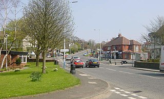
Failsworth is a suburb in the metropolitan borough of Oldham, Greater Manchester, England, 3.7 miles (6.0 km) north-east of Manchester city centre and 2.9 miles (4.7 km) south-west of Oldham. The orbital M60 motorway skirts it to the east. The population at the 2011 census was 20,680. Historically in Lancashire, Failsworth until the 19th century was a farming township linked ecclesiastically with Manchester. Locals upped their farming income with domestic hand-loom weaving. The humid climate and availability of labour and coal led to mass weaving of textiles, as a Lancashire Mill Town. A central landmark is the Failsworth Pole. Daisy Nook is a public country park on the southern boundary with Droylsden.

Saddleworth is a civil parish of the Metropolitan Borough of Oldham in Greater Manchester, England. It comprises several villages and hamlets as well as suburbs of Oldham on the west side of the Pennine hills.

The Metropolitan Borough of Oldham is a metropolitan borough of Greater Manchester, England. It has a population of 237,110, and spans 55 square miles (142 km2). The borough is named after its largest town, Oldham, but also includes the outlying towns of Chadderton, Failsworth, Royton and Shaw and Crompton, the village of Lees, and the parish of Saddleworth.

Royton is a town in the Metropolitan Borough of Oldham, Greater Manchester, England, with a population of 21,284 in 2011. Close to the source of the River Irk, near undulating land at the foothills of the South Pennines, it is 1.7 miles (2.7 km) northwest of Oldham, 3.2 miles (5.1 km) southeast of Rochdale and 7.6 miles (12.2 km) northeast of Manchester.

Oldham East and Saddleworth is a constituency in outer Greater Manchester represented in the House of Commons of the UK Parliament since January 2011 by Debbie Abrahams of the Labour Party.

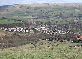
Uppermill is a village in Saddleworth—a civil parish of the Metropolitan Borough of Oldham, in Greater Manchester, England. Historically in the West Riding of Yorkshire, it lies on the River Tame in a valley amongst the South Pennines with the Peak District National Park directly to the east, and is 4.5 miles (7.2 km) east of Oldham, and 11 miles (17.7 km) east-northeast of Manchester. Uppermill forms a continuous urban area with the neighbouring village of Dobcross—the two have a combined population of 7,500.

Lees is a village in the Metropolitan Borough of Oldham, Greater Manchester, England, amongst the Pennines east of the River Medlock, 1.8 miles (2.9 km) east of Oldham, and 8.2 miles (13.2 km) northeast of Manchester.

The Greater Manchester Built-up Area is an area of land defined by the Office for National Statistics (ONS), consisting of the large conurbation that encompasses the urban element of the city of Manchester and the continuous metropolitan area that spreads outwards from it, forming much of Greater Manchester in North West England. According to the United Kingdom Census 2011, the Greater Manchester Built-up Area has a population of 2,553,379 making it the second most populous conurbation in the United Kingdom after the Greater London Built-up Area. This was an increase of 14% from the population recorded at the United Kingdom Census 2001 of 2,240,230, when it was known as the Greater Manchester Urban Area.

Shaw and Crompton is a civil parish in the Metropolitan Borough of Oldham, Greater Manchester, England, which contains the town of Shaw and lies on the River Beal at the foothills of the South Pennines. It is located 2.3 miles (3.7 km) north of Oldham, 3.6 miles (5.8 km) south-east of Rochdale and 8.7 miles (14 km) north-east of Manchester.

Springhead is a suburban area of Saddleworth, a civil parish of the Metropolitan Borough of Oldham, in Greater Manchester, England.

Scouthead is a hamlet within Saddleworth, a civil parish of the Metropolitan Borough of Oldham, in Greater Manchester, England. It is traversed by the A62 road, and occupies a hillside amongst the Pennines.

Waterhead, is an area of Oldham, and an electoral ward of the Metropolitan Borough of Oldham, in Greater Manchester, England. Historically in Lancashire, an upland area in the Pennines, the ward of Waterhead has population of 12,876, decreasing to 12,029 at the 2011 Census.

The geography of Greater Manchester is dominated by one of the United Kingdom's largest metropolitan areas, and in this capacity the landlocked metropolitan county constitutes one of the most urbanised and densely populated areas of the country. There is a mix of high density urban areas, suburbs, semi-rural and rural locations in Greater Manchester, but overwhelmingly the land use in the county is urban.

Whit Friday, meaning "white Friday", is the name given to the first Friday after Pentecost or Whitsun.
Grotton is an residential area in Saddleworth, a civil parish of the Metropolitan Borough of Oldham, in Greater Manchester, England. Located along the A669 road, it forms a continuous urban area with Austerlands and Springhead, which in turn link to Lees and Oldham, all of which are to Grotton's west.

Sholver is an area of Oldham, in Greater Manchester, England. An elevated, residential area, it lies near the middle of the Oldham part of the valley of the River Beal, 2.1 miles (3.4 km) northeast of Oldham's commercial centre, nearly at the northeasternmost extremity of the town, by open countryside close to the source of the River Medlock and by the border with Saddleworth.
Dobcross is a village in Saddleworth—a civil parish of the Metropolitan Borough of Oldham, in Greater Manchester, England. It is in a valley in the South Pennines, along the course of the River Tame and the Huddersfield Narrow Canal, 4.2 miles (6.8 km) east-northeast of Oldham and 13 miles (21 km) west-southwest of Huddersfield.

Denshaw is a village in Saddleworth—a civil parish of the Metropolitan Borough of Oldham, in Greater Manchester, England. It lies by the source of the River Tame, high amongst the Pennines above the village of Delph, 4.6 miles (7.4 km) northeast of Oldham,3.3 miles (5.3 km) north-northwest of Uppermill and Shaw and Crompton. It has a population of around 500.

Oldham Metropolitan Borough Council is the local authority of the Metropolitan Borough of Oldham in Greater Manchester, England. It is a metropolitan district council, one of ten in Greater Manchester and one of 36 in the metropolitan counties of England, and provides the majority of local government services in Oldham. It is composed of 60 councillors, three for each of the 20 electoral wards of the borough. It is also branded and known simply as Oldham Council.

