Avon, Missouri

Last updated

Avon, Missouri
Map of Missouri highlighting Sainte Genevieve County.svg
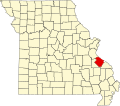
Location of Ste. Genevieve County, Missouri
Coordinates: 37°45′05″N90°13′24″W / 37.75139°N 90.22333°W / 37.75139; -90.22333
Country United States
State Missouri
County Sainte Genevieve
Township Saline
Elevation
730 ft (222.5 [1]  m)
Time zone UTC-6 (Central (CST))
  Summer (DST) UTC-5 (CDT)
ZIP code
63670
Area code 573
FIPS code 29-02782
GNIS feature ID713512

Avon is an unincorporated community located in Saline Township in Sainte Genevieve County, Missouri, United States. [2] Avon is located 20 miles southwest of Ste. Genevieve. [3] [1]

Contents

Etymology

Although the derivation of Avon's name is unknown, an admirer of Shakespeare may have chosen it, taking it from Shakespeare’s hometown Stratford-upon-Avon. [3]

History

Avon was first established as a lead mining camp, using furnaces to process the lead. [4] [5] A post office was in operation in Avon between 1849 and 1928. [6] In 1925, Avon had 21 inhabitants. [7]

Related Research Articles

<span class="mw-page-title-main">Ste. Genevieve County, Missouri</span> County in Missouri, United States

Sainte Genevieve County, often abbreviated Ste. Genevieve County, is a county located in the eastern portion of the U.S. state of Missouri. As of the 2020 census, the population was 18,479. The largest city and county seat is Ste. Genevieve. The county was officially organized on October 1, 1812, and is named after the Spanish district once located in the region, after Saint Genevieve, patroness of Paris, France.

<span class="mw-page-title-main">Ste. Genevieve, Missouri</span> City in Missouri, United States

Ste. Genevieve is a city in Ste. Genevieve Township and is the county seat of Ste. Genevieve County, Missouri, United States. The population was 4,999 at the 2020 census. Founded in 1735 by French Canadian colonists and settlers from east of the river, it was the first organized European settlement west of the Mississippi River in present-day Missouri. Today, it is home to Ste. Genevieve National Historical Park, the 422nd unit of the National Park Service.

<span class="mw-page-title-main">Coffman, Missouri</span> Unincorporated community in Missouri, United States

Coffman is an unincorporated community in Saline Township in southern Sainte Genevieve County, Missouri, United States. It is located approximately fifteen miles southwest of Ste. Genevieve.

<span class="mw-page-title-main">Union Township, Perry County, Missouri</span> Township in the US state of Missouri

Union is one of the eight townships located in Perry County, Missouri, in the United States of America.

<span class="mw-page-title-main">Bois Brule Bottom</span> Alluvial floodplain in the American state of Missouri

The Bois Brule Bottom is an alluvial floodplain in Bois Brule Township in Perry County, Missouri stretching between Bois Brule Creek to the west and the Mississippi River to the east.

<span class="mw-page-title-main">Beauvais Township, Ste. Genevieve County, Missouri</span> Civil Township in Missouri, United States

Beauvais Township is a subdivision of Ste. Genevieve County, Missouri, in the United States of America, and is one of the five townships located in Ste. Genevieve County.

<span class="mw-page-title-main">Saline Township, Ste. Genevieve County, Missouri</span> Civil township in Missouri, United States

Saline township is a subdivision of Ste. Genevieve County, Missouri, in the United States of America, and is one of the five townships located in Ste. Genevieve County.

<span class="mw-page-title-main">Ste. Genevieve Township, Ste. Genevieve County, Missouri</span> Civil Township in Missouri, United States

Ste. Genevieve Township is a subdivision of Ste. Genevieve County, Missouri, in the United States of America, and is one of the five townships located in Ste. Genevieve County.

Arnsberg is an unincorporated community in Cape Girardeau County, Missouri, United States.

Amy is an unincorporated community in Howell County, Missouri, United States. The community is located 12 miles (19 km) southwest of West Plains.

Altona is an unincorporated community in northern Bates County, in the U.S. state of Missouri. The community is on Missouri Route Z just north of Missouri route 18 and approximately 5.5 miles east of Adrian.

Arbor is an unincorporated community in Cape Girardeau County, in the U.S. state of Missouri.

Antioch is an unincorporated community in Clark County, in the U.S. state of Missouri.

Arden is an unincorporated community in western Douglas County, Missouri, United States. Arden is located on a ridge along Missouri Route O between Missouri Route 14 to the north and the community of Red Bank to the south. The community is on a ridge of Keyger Mountain at an elevation of 1,362 ft (415 m).

<span class="mw-page-title-main">Mosher, Missouri</span> Unincorporated community in the American state of Missouri

Mosher is an unincorporated community in Ste. Genevieve Township in eastern Sainte Genevieve County, Missouri, United States. It is situated approximately two miles west of Ste. Genevieve. The community most likely was named after a local French colonial family Mosier or Mosieur. English spelling of the French pronunciation may account for the spelling of the community's name. The community developed as a stop along the Missouri-Illinois Railroad.

Arditta is an unincorporated community in southwest Howell County, in the Ozarks of southern Missouri, United States. Arditta is located on U.S. Route 160 between Egypt Grove and Caulfield. It is approximately twelve miles southwest of West Plains.

Abo is an unincorporated community in eastern Laclede County, in the Ozarks of south central Missouri. The community is located on the east bank of the Osage Fork Gasconade River, approximately ten miles east of Lebanon.

Agnes is an unincorporated community in southern Laclede County, Missouri, United States. Agnes is located on State Route O on the west side of Cobb Creek and approximately three miles north of the Laclede-Wright County line.

Apex is an unincorporated community in Lincoln County, in the U.S. state of Missouri.

Argentville is an unincorporated community in Lincoln County, in the U.S. state of Missouri.

References

  1. 1 2 "Avon (Sainte Genevieve County, Missouri): Summarized Details". RoadsideThoughts. Retrieved November 8, 2019.
  2. U.S. Geological Survey Geographic Names Information System: Avon, Missouri
  3. 1 2 "Ste. Genevieve County, Missouri Place Names, 1928-1945 - The State Historical Society of Missouri". The State Historical Society of Missouri. July 1, 2015. Archived from the original on July 1, 2015. Retrieved November 8, 2019.
  4. William Franklin Switzler; Robert Allen Campbell; Alban Jasper Conant; George Clinton Swallow (1879). "Switzler's Illustrated History of Missouri, from 1541 to 1877". C. R. Barns: 562. avon.{{cite journal}}: Cite journal requires |journal= (help)
  5. Robert Allen Campbell (1874). "Campbell's Gazetteer of Missouri: From Articles Contributed by Prominent Gentlemen in Each County of the State, and Information Collected and Collated from Official and Other Authentic Sources".{{cite journal}}: Cite journal requires |journal= (help)
  6. Missouri Postal History "Ste. Genevieve". Archived from the original on October 21, 2013. Retrieved October 8, 2013.
  7. Rand McNally and Company (1925). Premier Atlas of the World: Containing Maps of All Countries of the World, with the Most Recent Boundary Decisions, and Maps of All the States, Territories, and Possessions of the United States with Population Figures from the Latest Official Census Reports, Also Data of Interest Concerning International and Domestic Political Questions. Rand McNally & Company. p. 259. Retrieved February 19, 2023.