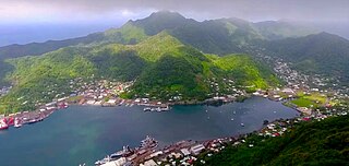
Pago Pago is the capital of American Samoa. It is in Maoputasi County on Tutuila, which is American Samoa's main island.

Fagatogo is the downtown area of Pago Pago. Located in the low grounds at the foot of Matafao Peak, it was the location of the first American settlement on Tutuila Island. It includes the sub-village of Malaloa. Today, Fagatogo is the government, commercial, financial, and shipping center of Tutuila. It is also the administrative capital of American Samoa. It is the location of the American Samoa Fono (legislature), and is listed in the Constitution of American Samoa as the territory's official seat of government. Its population is 1,737.

Pago Pago International Airport, also known as Tafuna Airport, is a public airport located 7 miles (11.3 km) southwest of the central business district of Pago Pago, in the village and plains of Tafuna on the island of Tutuila in American Samoa, an unincorporated territory of the United States.
Utulei or ʻUtulei is a village in Maoputasi County, in the Eastern District of Tutuila, the main island of American Samoa. Utulei is traditionally considered to be a section of Fagatogo village, the legislative capital of American Samoa, and is located on the southwest edge of Pago Pago Harbor. Utulei is the site of many local landmarks: The A. P. Lutali Executive Office Building, which is next to the Feleti Barstow Library; paved roads that wind up to a former cablecar terminal on Solo Hill; the governor's mansion, which sits on Mauga o Alii, overlooking the entrance to Goat's Island, and the lieutenant governor's residence directly downhill from it; the Lee Auditorium, built in 1962; American Samoa's television studios, known as the Michael J. Kirwan Educational Television Center; and the Rainmaker Hotel. Utulei Terminal offers views of Rainmaker Mountain.

Rainmaker Mountain is the name of a mountain located near Pago Pago, American Samoa on Tutuila Island. Rainmaker Mountain traps rain clouds and gives Pago Pago the highest annual rainfall of any harbor. The average annual rainfall on the mountain is around 200 inches (510 cm). It has a three-pronged summit. Rainmaker Mountain and its base were designated a National Natural Landmark in 1972 due to the slopes’ tropical vegetation.

Leone is the second-largest city on Tutuila Island's west coast. The village is on the south-west coast of Tutuila Island, American Samoa. Leone was the ancient capital of Tutuila Island. Leone was also where the Samoan Islands’ first missionary, John Williams, visited on October 18, 1832. A monument in honor of Williams has been erected in front of Zion Church. Its large church was the first to be built in American Samoa. It has three towers, a carved ceiling and stained glass. Until steamships were invented, Leone was the preferred anchorage of sailing ships which did not risk entering Pago Pago Harbor. Much early contact between Samoans and Europeans took place in Leone.

Tafuna is a village in Tualauta County, Western District, American Samoa. It is the most populous village in American Samoa, with a population of 7,988 according to the 2020 U.S. Census, and is the center of nightlife on island.

American Samoa is an unincorporated territory of the United States located in the South Pacific Ocean, southeast of the island country of Samoa. Centered on 14.3°S 170.7°W, it is east of the International Date Line and the Wallis and Futuna Islands, west of the Cook Islands, north of Tonga, and some 500 kilometers (310 mi) south of Tokelau. American Samoa is the southernmost territory of the United States and one of two U.S. territories south of the Equator, along with the uninhabited Jarvis Island.

Alega is a village on the southeast coast of Tutuila Island, American Samoa. One of the island's least populous villages, it is located to the east of Pago Pago Harbor and to the west of Faga'itua Bay.
Alofau is a village on the southeast coast of Tutuila Island, American Samoa. It is located at the eastern end of Faga'itua Bay, six miles east of Pago Pago, between Pagai and Amouli. It is home to Alofau Village Marine Protected Area. It is an agrarian and traditional village. It is also a poor village with residents with low literacy and high unemployment rates. As of the U.S. Census 2000, the per capita income was $4,357 and 67 percent of children were below the poverty line. 15.6 percent of residents were receiving public assistance. It is lauded as a kava place in the Manu'a Songs. Alofau is located in Sa'Ole County.
Anua is a village on Tutuila Island, American Samoa. It is located close to the capital Pago Pago, on the coast of Pago Pago Harbor. The term Pago Pago is often used for several settlements on Pago Pago Bay, including Anua, Lepua, Utulei, and others.
ʻAoa is a village on the north-east coast of Tutuila Island, American Samoa. It is located on the north coast, close to the island's eastern tip, at a narrowing of the island and is connected by road with Amouli on the south coast. ʻAoa is the oldest site on Tutuila to yield ceramics. Located in a large U-shaped valley on the northeast coast of the island, ʻAoa sits on a wide, sandy beach fronted by a large, deep bay. Fresh water is supplied by a steady river which runs through the village. It is located in Vaifanua County.
Pago Pago Harbor on Tutuila Island in American Samoa is one of the world's largest natural harbors. The capital, Pago Pago is located on the inner reaches of the harbor, close to its northwesternmost point. It has the highest annual rainfall of any harbor in the world. It is also considered one of the best and deepest deepwater harbors in the South Pacific Ocean or in Oceania as a whole. Pago Pago Bay is over 400 feet (120 m) deep and two miles (3.2 km) long. As part of the Pago Volcano caldera, the harbor is 50% landlocked.
Fagaʻalu is a village in central Tutuila Island, American Samoa. It is also known as Fagaʻalo. It is located on the eastern shore of Pago Pago Harbor, to the south of Pago Pago. American Samoa's lone hospital, Lyndon B. Johnson Tropical Medical Center, is located in Fagaʻalu. The village is centered around Fagaalu Stream.
Athletics competitions at the 1997 South Pacific Mini Games were held at the Veterans Memorial Stadium in Pago Pago, American Samoa, between August 15–20, 1997.

Severe Tropical Cyclone Tusi was a tropical cyclone which affected the island nations of Tuvalu, Tokelau, Western Samoa, American Samoa, Niue and the Southern Cook Islands during January 1987. The precursor tropical depression to Cyclone Tusi developed on January 13, within a trough of low pressure near the island nation of Tuvalu. Over the next few days the system gradually developed further before it was named Tusi during January 16, after it had become equivalent to a modern-day category 1 tropical cyclone on the Australian tropical cyclone intensity scale. After being named the system gradually intensified as it moved southeastwards along the trough, between the islands of Fakaofo and Swains during January 17. Tusi's eye subsequently passed near or over American Samoa's Manu'a Islands early the next day, as the system peaked in intensity with 10-minute sustained wind speeds of 150 km/h (90 mph). The system subsequently posed a threat to the Southern Cook Islands, however this threat gradually diminished as Tusi moved southwards and approached 25S during January 20.

Vatia is a village on Tutuila Island in American Samoa. It is a north shore village located on Vatia Bay. The road to Vatia, American Samoa Highway 006, is the only road going through National Park of American Samoa. Vatia is a scenic community at the foot of Pola Ridge and surrounded by the national park. It is only reached by Route 6 which traverses the national park before reaching Vatia. There was once a hiking trail over Maugaloa Ridge from Leloaloa, but since the completion of Route 6, this trail is now overgrown. It is home to a beach, and panoramic views of jungle-covered peaks surround the village on all sides. Vatia is the center of the Tutuila-section of National Park of American Samoa. It is located in Vaifanua County.
Fagasā is a village in the Eastern District of Tutuila Island in American Samoa. The village lies by Fagasa Bay, on the north shore of the island. Its name is Samoan and translates to "Forbidden Bay." The village borders the Tutuila-section of National Park of American Samoa. The trailhead to Mount 'Alava is located near the village by Fagasa Pass.
Lumā is a village on the northwest coast of Taʻū Island in American Samoa, south of the village of Taʻū and north of Siʻufaga. The last Tui Manuʻa is buried in Lumā. It is also where anthropologist Margaret Mead researched and authored her classic Coming of Age in Samoa in 1925. Lumā and neighboring Siʻufaga are subvillages of the Village of Taʻū.

Severe Tropical Cyclone Gita was the most intense tropical cyclone to impact Tonga since reliable records began. The second named storm and first major tropical cyclone of the 2017–18 South Pacific cyclone season, Gita originated from a monsoon trough that was active in the South Pacific in early February 2018. First classified as a tropical disturbance on 3 February, the nascent system meandered near Vanuatu for several days with little development. After acquiring a steady east trajectory near Fiji, it organized into a Category 1 tropical cyclone on 9 February near Samoa. Arcing south in a clockwise turn, the system rapidly intensified, and became a severe tropical cyclone on 10 February near Niue.
