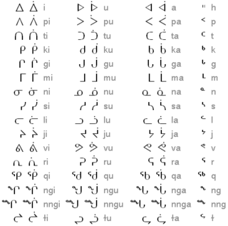
Inuktitut syllabics is an abugida-type writing system used in Canada by the Inuktitut-speaking Inuit of the territory of Nunavut and the Nunavik and Nunatsiavut regions of Quebec and Labrador, respectively. In 1976, the Language Commission of the Inuit Cultural Institute made it the co-official script for the Inuit languages, along with the Latin script.

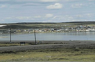
Baker Lake is a lake in the Kivalliq Region, Nunavut, Canada. It is fed by the Thelon River from the west and the Kazan River from the south. It outflows into Chesterfield Inlet. The lake is approximately 1,887 km2 (729 sq mi) in size. It has several named bays, and a few islands.

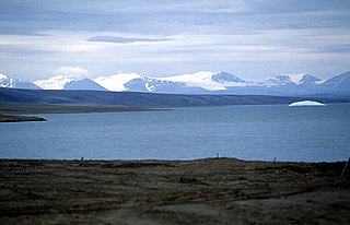
Clyde River is an Inuit hamlet located on the shore of Baffin Island's Patricia Bay, off Kangiqtugaapik, an arm of Davis Strait in the Qikiqtaaluk Region, of Nunavut, Canada. It lies in the Baffin Mountains which in turn form part of the Arctic Cordillera mountain range. The community is served by air and by annual supply sealift.

The Soper River is a waterway on Baffin Island, Nunavut. The river flows over 100 km (62 mi) and then empties into Soper Lake and Pleasant Inlet. The Soper River was designated a Canadian Heritage River in 1992.

The Tree River (Kogluktualuk) is a river in Nunavut, Canada. It flows into Coronation Gulf, an arm of the Arctic Ocean.
Katannilik Territorial Park Reserve is a territorial park in the Qikiqtaaluk Region of Nunavut, Canada. It was established in 1993 and has an area of 1,262 km2 (487 sq mi). The Soper River, part of the Canadian Heritage Rivers System, flows through the park.

Dewey Soper Migratory Bird Sanctuary, or Dewey Soper, is a migratory bird sanctuary in the Qikiqtaaluk Region, Nunavut, Canada. It is located in western Baffin Island, from Bowman Bay to the Koukdjuak River, and is named in honour of zoologist J. Dewey Soper. It is an 8,159 km2 (3,150 sq mi) area that was classified a wetland of international importance via the Ramsar Convention on May 24, 1982. The bird sanctuary supports nearly 30% of the breeding geese in Canada, making it the largest goose colony in the world. Up to two million birds of various species use the area for summer nesting, and it is also "habitat for one of Canada's major barren-ground caribou herds". The sanctuary was established in 1957, and is subject to the Nunavut Land Claims Agreement, which defines and governs ownership, land use and hunting rights in the area.

Mount Odin is a mountain in Qikiqtaaluk, Nunavut, Canada. It is located in Auyuittuq National Park along the Akshayuk Pass, 46 km (29 mi) north of Pangnirtung and south of Mount Asgard. Mount Odin is the highest mountain on Baffin Island.
The McConnell River Migratory Bird Sanctuary is located in the Kivalliq Region of Nunavut, Canada. The 32,800 hectare sanctuary is on Hudson Bay's west coast, 27 km south of Arviat, and 50 km north of the Manitoba border. Its namesake is the McConnell River which flows to the Hudson Bay. The Bird Sanctuary is home to and an important breeding ground for cackling goose, lesser snow goose, Ross's goose, and Canada goose.

The Sawtooth Range is a jagged snow-capped mountain range on central Ellesmere Island, Nunavut, Canada. It lies between the Fosheim Peninsula and the Wolf Valley. The Sawtooth Range is a subrange of the Arctic Cordillera. It also runs through a Canadian Forces Station, called Eureka, a base used to study atmospheric changes.
The McConnell River is located in the Kivalliq Region of northern Canada's territory of Nunavut. It drains into Hudson Bay and is the namesake for the McConnell River Migratory Bird Sanctuary.

Otrick Island is a member of the Canadian Arctic Archipelago in the territory of Nunavut. The uninhabited island lies in Peel Sound, south of Somerset Island's Four Rivers Bay. The equally small Barth Island is to the south.

Barth Island an uninhabited island in the Qikiqtaaluk Region of Nunavut, Canada. It is located in Peel Sound, south of Somerset Island's Four Rivers Bay, and the equally small Otrick Island. Prince of Wales Island is to the west.

Perry River (Kuugjuaq) is a waterway in the Kitikmeot Region, Nunavut, Canada. It empties into Chester Bay on the southern Queen Maud Gulf.
The Richardson River is a waterway that flows into Richardson Bay, Coronation Gulf in the northern Canadian territory of Nunavut. Its mouth is situated northwest of Kugluktuk, Nunavut. The Rae River is 1.3 km (0.81 mi) away.
The Roscoe River is a waterway located above the Arctic Circle on the mainland of Northern Canada.
The Kagloryuak River is located on Victoria Island in Northern Canada, commencing in Nunavut and ending in the Northwest Territories. Starting from the central plains, it flows west into Prince Albert Sound.

Napaktulik Lake formerly Takiyuak Lake or Takijuq Lake is the eighth largest lake in Nunavut, Canada. It is located 173 km (107 mi) south of Kugluktuk and is the source of the Hood River.

The Hargrave River is a river in the Arctic Ocean drainage basin in Kitikmeot Region, Nunavut, Canada. It is on the Kent Peninsula, and has its mouth on Dease Strait.


