Bakarpur

Last updated

Bakarpur
Migratory birds at village pond Bakarpur, Mohali, Punjab, India 01.JPG
village pond
India Punjab location map.svg
Red pog.svg
Bakarpur
Location in Punjab, India
India location map.svg
Red pog.svg
Bakarpur
Bakarpur (India)
Coordinates: 30°39′N76°49′E / 30.65°N 76.82°E / 30.65; 76.82
CountryFlag of India.svg  India
State Punjab
Languages
  Official Punjabi
Time zone UTC+5:30 (IST)
PIN
140306

Bakarpur is a large village in Mohali district in the Indian state of Punjab. Bakarpur had previously been shifted from Ambala district to Rupnagar district on formation of Haryana state on 1 November 1966. Further, on formation of Mohali district, it had been shifted to it in 2006. Now it is getting developed fast like a town. There is a large market, government senior secondary school, Primary health centre, veterinary hospital, IndusInd Bank, HDFC Bank and Punjab Gramin Bank. In 2009/10 large area of cultivated land of Bakarpur was acquired by the Greater Mohali Area Development Authority (GMADA) for construction of a 200-foot-wide (61 m) road from Mohali City to Mohali Airport which is also being connected to the Zirakpur-Patiala Road. Now the GMADA is going to develop new sectors along with this road and the same has been named as Aerocity. In year 2010 residential plots have been allotted by GMADA to the public by draw of lots. This village is on the newly created Mohali airport road.

Contents

Sarhind to bakarpur

Village Bakarpur is located at a distance of 8 kilometers from Mohali, about 3 km (1.9 mi) from Chhatt Bir and about 6 km (3.7 mi) from Zirakpur. It is 3 km (1.9 mi) from Mohali International Airport.

Language

Puadhi and Punjabi are main spoken languages in Bakarpur. Hindi is the second language in this village.

Administration

The village is managed by Gram Panchayat.

Dera Dargah Sharif Bakarpur


Sai Surinder Singh is currently the chief dera head of dargah sharif Bakarpur.Surinder Singh was born on 11 November 1988 at Bakarpur.

There is a popular shrine in the village known as Dera Bakarpur, where all the 5 pirs live. These pirs are Gogaji Jahar Peer, Bagad, Lakhdata pir, Ghauns Paak Sarkaar (11vi da peer), Sabir Pak (Baba Farid's nephew), Hazarat Sheikh Malerkotla and khvaja pir. Dera Bakarpur is the home for the family of Ali. This place is also known as the Darbaar of Sarkar Abdul Qadir Jalani Gyarnvi wali Sarkar Hajrate Sayeed Janaab "Ghauns Paak" peer ji and Guga Jahar Veer ji. As per tradition people visit the Dera Bakarpur to fulfil their wishes and to obtain the blessings of God.

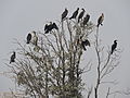
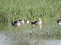
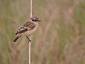
Village pond and migratory birds

The village has a large size village pond which contain water for most of the period of the year. In winter this pond attracts a large number of migrant birds. But area of this pond has now been acquired by Punjab Government along with other area of village to develop well known township of Mohali known as Aerocity City [ citation needed ] and this pond is likely to be abolished possibly to develop the commercial complex here . In the coming seasons these birds may not come here again. Migratory birds visiting this pond include cormorant, purple heron, grey horn, painted stork, and many local water birds and sparrow.

Gurudwaras & temples

Attractions

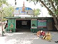
The Mahendra Chaudhary Zoological Park (Chhatbir Zoo) located in Chhatt village 3 km (1.9 mi) from Bakarpur village.

Related Research Articles

<span class="mw-page-title-main">Mohali</span> City in Punjab, India

Mohali, officially known as Sahibzada Ajit Singh Nagar, is a planned city in the Mohali district in Punjab, India, which is an administrative and a commercial hub lying south-west of Chandigarh. It is the headquarters of the Mohali district and one of the six Municipal Corporations of the State. It is officially named after Sahibzada Ajit Singh, the eldest son of Guru Gobind Singh.

<span class="mw-page-title-main">Gogaji</span> Indian folk deity

Gogaji is a folk deity, worshipped in the northern states of India especially in Rajasthan, Himachal Pradesh, Haryana, Uttarakhand, Punjab region, Uttar Pradesh, Jammu and Gujarat. He is a warrior-hero of the region, venerated as a saint and a 'snake-god'.

<span class="mw-page-title-main">Batala</span> City in Punjab, India

Batala is the eighth largest city in the state of Punjab, India in terms of population after Ludhiana, Amritsar, Jalandhar, Patiala, Bathinda, Mohali and Hoshiarpur. Batala ranks as the second-oldest city after Bathinda. It is a municipal corporation in Gurdaspur district in the Majha region of the state of Punjab. It is located about 32 km from Gurdaspur, the headquarters of the district. It is also a Police district. Batala holds the status of the most populated town of the district with 31% of the district's total population. It is the biggest industrial town in the district.

<span class="mw-page-title-main">Mohali district</span> District of Punjab in India

Mohali district, officially known as Sahibzada Ajit Singh Nagar district or SAS Nagar district, is one of the twenty three districts of Punjab, a state in north-west India. It was formed in April 2006 and is 18th district of Punjab, created next to Pathankot district. This district was carved out of areas falling in Ropar and Patiala District. It is situated next to the union territory of Chandigarh, Ambala And Panchkula district of Haryana.

Balachaur is a town in Balachaur Tehsil in the Shaheed Bhagat Singh Nagar District of Punjab, India.

Dera Bassi is a satellite city of Chandigarh and a municipal council in Mohali district in the state of Punjab, India. Dera Bassi is located on the Chandigarh – Delhi National Highway, 8 km from Chandigarh. It is located within 20 km from Chandigarh, Mohali and Panchkula. It is strategically located near the boundary of Haryana, Punjab and Union territory of Chandigarh. Derabassi is most famous for its industrial belt, situated for the most part on Ramgarh and Barwala Road. The nearby sub town of Lalru was once a famous market for red chilli powder. The city and the nearby area host eight Engineering, B.Ed., Paramedical and Management institutes.

Samana is a town and a municipal council, nearby Patiala City in Patiala district in the Indian state of Punjab.

<span class="mw-page-title-main">Zirakpur</span> Town in Punjab, India

Zirakpur is a satellite town, in Mohali District, Punjab, neighboring Mohali, Chandigarh in India. It is set on the foothills of Shivalik hills. It is part of the tehsil Dera Bassi. It is the gateway to Chandigarh from Delhi. It comprises mainly the following areas near Chandigarh Airport including VIP Road, Dhakoli, Lohgarh, Bhabat, Bishanpura, Kishanpura, Nabha, Gazipur, Baltana, Singhpura, Peer Muchalla and Dyalpura. This town is situated on the junction of national highways Himalayan Expressway, National Highway 5 (India) towards Shimla, Ambala Chandigarh Expressway towards Ambala and National Highway 7 (India) towards Patiala.

<span class="mw-page-title-main">Puadh</span> Historic region in north India

Puadh is a historic region in north India that comprises parts of present-day Punjab, Haryana, Uttar Pradesh, Himachal Pradesh and the U.T. of Chandigarh, India. It has the Sutlej river in its north and covers the regions immediately south of the Ghaggar river. The people of the area are known as Puadhi and speak the Puadhi dialect of Punjabi. The capital cities of Puadh region are Rupnagar, Fatehgarh Sahib, Mohali, Patiala, Chandigarh, Nalagarh,Panchkula, Baddi ,Ambala, Yamunanagar

<span class="mw-page-title-main">Chandigarh Capital Region</span> Area in India

Chandigarh Capital Region (CCR) or Chandigarh Metropolitan Region (CMR) is an area, which includes the union territory city of Chandigarh, and its neighboring cities of Mohali, Kharar, Zirakpur, New Chandigarh (in Punjab) and Panchkula, Pinjore, Kalka, Barwala (in Haryana). Chandigarh Administration, Greater Mohali Area Development Authority (GMADA) and Haryana Urban Development Authority (HUDA) are different authorities responsible for development of this region. Baddi, an industrial town in nearby Himachal Pradesh, is also adjacent.

Sahauran is a village in Mohali district, Punjab, India, located on NH 205. The village falls under tehsil Kharar, and is about 23 km (14 mi) from Chandigarh. The neighbouring towns of village sahauran are Kurali, Kharar, Ropar. The nearest airport is Chandigarh International Airport which is 28 km (17 mi) away from village. The population is about 5000.

Chandigarh Metro is an approved rapid transit system to serve the Chandigarh Capital Region, which includes Chandigarh and adjacent areas in Punjab and Haryana states of India. In Phase-1, to be progressively built and operationalised between 2027 to 2034, 3 lines will connect tri-cities of Chandigarh, Mohali in Punjab and Panchkula in Haryana. Phase-2, to be constructed after 2034, will connect Pinjore in Haryana and further expand the network in Mohali with 2 more lines. The project, which was initially scrapped in 2017 due to low financial viability, was approved in March 2023 and received formal clearance in July 2023 from the governments of Punjab and Haryana after a Detailed Project Report (DPR) was created.

Gaggon is a village in Rupnagar (Ropar) district of Punjab. It has population of 578 and total area of 2.4 km2. It is 5 km from Chamkaur and 12 km from district headquarters Ropar.

Rampur Sainian is a village situated in the north east of Dera Bassi in the Mohali district of Indian state of Punjab. It is on Dera Bassi-Barwala link road 6 km away from Dera Bassi. It is on the Punjab-Haryana border and is about 267 km (166 mi) from the national capital New Delhi. It is just 26 km (16 mi) away from both Chandigarh and Panchkula. In this age of industrialization, this village is also not untouched. A lot of industries can be noticed on Dera Bassi-Barwala link road to Rampur Sanian.

A Shaheed Shrine is a building constructed to commemorate and show respect to a saint and forms part of Punjabi folk religion in the Punjab region.

Peer Muchalla is a town in Municipal Council Zirakpur in district Mohali in state of Punjab in India. It adjoins Sector 20 of Panchkula. Proximity to Chandigarh, Mohali, Panchkula and Airport is attracting property builders to this area. It is coming up as a posh area and developed suburb of Zirakpur and Panchkula with many multi-storey residential complexes.

Sector 70 is a residential and historical sector located in Mohali, Punjab. It is covered with Mattaur, Sector 71, Sohana, Sector 69 and Phase 7, Mohali. There are many parks, around 10, in locality among which famous is Musical Fountain Park for evening stroll and recreation activities. There are many residential complex, apartments and societies.

Chak Sahbu is a small village in Jalandhar District of Punjab State, India. The village is administrated by Sarpanch who is elected representative of village. It is located 49 km towards East from Jalandhar, 14 km from Phillaur and 119 km from Chandigarh. The nearest census town and marketplace is located 1 km in Apra, Punjab. The nearest train station is situated 13.9 km away in Phillaur, nearest domestic airport is at Ludhiana and the nearest international airport is 143 km away in Amritsar.

Nagar is a village in the Phillaur tehsil of Jalandhar District of the Indian state of Punjab. It is located on Phillaur-Nawanshahr Road, 6.7 kilometres (4.2 mi) from the head postal office in Phillaur, 7 kilometres (4.3 mi) from Apra, 50 kilometres (31 mi) from Jalandhar, and 117 kilometres (73 mi) from the state capital of Chandigarh. The village is administered by the Sarpanch, an elected representative.

Folk practices prevalent in Punjab incorporate local mysticism and refers to the beliefs and practices strictly indigenous to the Punjabi people, of the Punjab region including ancestral worship, veneration of saints, and local festivals. There are many shrines in Punjab which represent the folk religion of the Punjab region which is a discourse between different organised religions. These shrines represent inter-communal dialogue and a distinct form of cultural practice of saint veneration.

References