Zirakpur

Last updated

Zirakpur
Town
Zirakpur.jpg
India Punjab location map.svg
Red pog.svg
Zirakpur
Location in Punjab, India
Coordinates: 30°39′N76°49′E / 30.65°N 76.82°E / 30.65; 76.82
CountryFlag of India.svg  India
State Punjab
District Mohali
Elevation
350 m (1,150 ft)
Population
 (2011) [1]
  Total95,553
Languages
  Official Punjabi
Time zone UTC+5:30 (IST)
PIN
140603/140604/160104
Telephone code+91-1762-XXX XXX
Vehicle registration PB-70

Zirakpur is a planned [2] satellite city, in Mohali District, Punjab, neighboring Mohali, Chandigarh in India. It is set on the foothills of Shivalik hills. It is part of the tehsil Dera Bassi. It is the gateway to Chandigarh from Delhi. It comprises mainly the following areas near Chandigarh Airport including VIP Road, Dhakoli, Lohgarh, Bhabat, Bishanpura, Kishanpura, Nabha, Gazipur, Baltana, Singhpura, Peer Muchalla and Dyalpura. This town is situated on the junction of national highways Himalayan Expressway, National Highway 5 (India) towards Shimla, Ambala Chandigarh Expressway towards Ambala and National Highway 7 (India) towards Patiala.

Contents

Areas nearby

Sectors in Zirakpur

Zirakpur has also been divided into 16 sectors. [5] A sector map is yet to be put at different locations. It would be much help to people, but it would make it difficult to manipulate wards with gerrymandering during elections.

The colonies and villages falling in each sector are as under:

History

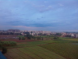
Zirakpur got its name from a small village, which is now a part of the present Zirakpur town. For long it remained a bunch of small villages located along the Chandigarh-Ambala highway. Then Chandigarh started to expand, and these villages started to seem like a part of Chandigarh. Before the year 2000, the city had a population of less than twenty thousand. Soon a small village Baltana, which is a part of Zirakpur now, started having some population growth being near Panchkula and Chandigarh. The upcoming 5500-acre GMADA Aerotropolis project near Dayalpura has increased the interest of investors in the region.

Public transport and traffic

Zirakpur is well connected through air-conditioned and non-air-conditioned local buses with Chandigarh, Panchkula and other neighbouring areas. The inter-state buses going from Chandigarh to Delhi, Patiala, Rajpura, Bathinda and most of the northern cities of Haryana pass through Zirakpur. Zirakpur is located on the Ambala-Chandigarh highway and the Patiala-Shimla highway. The nearest railway station is Chandigarh, which is around 7 km from Zirakpur. [6] The nearest airport is situated in Chandigarh at around 5 km from Zirakpur.

The Municipal authorities in Zirakpur have been under sharp criticism from the various resident associations of the area for not maintaining the roads and thereby leading to dangerous situations for the people commuting. [7]

The process to divide Zirakpur into various sectors like Chandigarh has been initiated, as per the latest Municipal Council meeting. [8] There has been a demand to name Zirakpur as "South Chandigarh", and sectors numbers starting from 201 onwards. This would give unique sector numbers to the whole Tricity, with Panchkula sector numbers starting from 301 and Mullanpur sector numbers starting from 401, thus making addresses short and removing confusion arising from the same sector numbers in adjoining towns.

Sports

There's an SAI (Sports Authority of India) regional center [9] near Nabha Sahib. Upon completion it will cater to Himachal Pradesh, Jammu & Kashmir, Chandigarh and Punjab. [10] The SAI center is spread across 15 acres and will have a football field, gymnasium hall, administrative block, indoor sports facilities and a six-lane athletics track. A big Sports Authority of India stadium for differently abled people is also coming up in Dayalpura [4] also so many private sports academies are available for various sports activities.

Demographics

The Zirakpur Municipal Council has a population of 95,553 of which 50,497 are males while 45,056 are females as per a report released by Census India 2011. The population of children ages 0–6 is 12074 which is 12.64% of the total population of Zirakpur (M Cl). In Zirakpur Municipal Council, the Female Sex Ratio is 892 against the state average of 895. Moreover, the Child Sex Ratio in Zirakpur is around 855 compared to the Punjab state average of 846. The literacy rate of Zirakpur city is 88% higher than the state average of 75.84%. In Zirakpur, male literacy is around 91% while the female literacy rate is 85%. [11]

Politics

The town is organized into 31 wards which constitute the municipal council.

Ward NoName of municipal CouncillorArea/Colonies in Ward
Sh. Udayvir Singh Dhillon(President) [12]
16Narmial SinghChatt Village, Dayalpura
18Tejinder Singh (Teji)Lohgarh, Balaji Enclave 2, Sigma city 1 & 2, Skynet Enclave [13]

See also

Related Research Articles

<span class="mw-page-title-main">Patiala</span> City in Punjab, India

Patiala is a city in southeastern Punjab, northwestern India. It is the fourth largest city in the state and is the administrative capital of Patiala district. Patiala is located around the Qila Mubarak constructed by a chieftain Ala Singh, who founded the royal dynasty of Patiala State in 1763, and after whom the city is named.

<span class="mw-page-title-main">Mohali</span> City in Punjab, India

Mohali, officially Sahibzada Ajit Singh Nagar, is a planned city in the Mohali district in Punjab, India, which is an administrative and a commercial hub lying south-west of Chandigarh. It is the headquarters of the Mohali district and one of the six Municipal Corporations of the State. It is officially named after Sahibzada Ajit Singh, the eldest son of Guru Gobind Singh.

<span class="mw-page-title-main">Cis-Sutlej states</span> Group of states in northwestern India

The Cis-Sutlej states were a group of states in the contemporary Punjab and Haryana states of northern India during the 19th century, lying between the Sutlej River on the north, the Himalayas on the east, the Yamuna River and Delhi District on the south, and Sirsa District on the west. The small Punjabi kingdoms of the Cis-Sutlej states paid tributes to the Marathas, until the Second Anglo-Maratha War of 1803–1805, after which the Marathas lost this territory to the British.

<span class="mw-page-title-main">Panchkula</span> City in Haryana, India

Panchkula is a city and district headquarter in the Panchkula district in Haryana, India. It is a satellite town of the state capital Chandigarh. Panchkula is a border city with Punjab, Chandigarh and Himachal Pradesh. The origin of the name Panchkula came from "the place where five irrigation canals meet". It is approximately 4 km (2.5 mi) southeast of Chandigarh, 105 km (65 mi) southwest of Shimla, 44 km (27 mi) from Ambala and 259 km (161 mi) northeast of New Delhi, the national capital. It is a part of the Chandigarh capital region or Greater Chandigarh. The Chandigarh-Mohali-Panchkula metropolitan region collectively forms a Chandigarh Tricity, with a combined population of over two million.

<span class="mw-page-title-main">Mohali district</span> District of Punjab in India

Mohali district, officially known as Sahibzada Ajit Singh Nagar district or SAS Nagar district, is one of the twenty three districts of Punjab, a state in north-west India. It was formed in April 2006 and is 18th district of Punjab, created next to Pathankot district. This district was carved out of areas falling in Ropar and Patiala District. It is situated next to the union territory of Chandigarh, Ambala and Panchkula districts of Haryana.

Dera Bassi is a satellite city of Chandigarh and a municipal council in Mohali district in the state of Punjab, India. Dera Bassi is located on the Chandigarh – Delhi National Highway, 8 km from Chandigarh. It is located within 20 km from Chandigarh, Mohali and Panchkula. It is strategically located near the boundary of Haryana, Punjab and Union territory of Chandigarh. Derabassi is most famous for its industrial belt, situated for the most part on Ramgarh and Barwala Road. The nearby sub town of Lalru was once a famous market for red chilli powder. The city and the nearby area host eight Engineering, B.Ed., Paramedical and Management institutes.

<span class="mw-page-title-main">Chandimandir Cantonment</span>

Chandimandir Cantonment is a military cantonment of the Indian Army located in Panchkula district at the foot of the Sivalik Hills adjoining Panchkula city in Haryana. It is the headquarters of the Western Command of the Indian Army.

<span class="mw-page-title-main">Puadh</span> Historic region in north India

Puadh is a historic region in north India that comprises parts of present-day Punjab, Haryana, Uttar Pradesh, Himachal Pradesh and the U.T. of Chandigarh, India. It has the Sutlej river in its north and covers the regions immediately south of the Ghaggar river. The people of the area are known as Puadhi and speak the Puadhi dialect of Punjabi. The capital cities of Puadh region are Rupnagar, Fatehgarh Sahib, Mohali, Patiala,Sangrur, Mansa Chandigarh, Nalagarh,Panchkula, Baddi ,Ambala, Yamunanagar

<span class="mw-page-title-main">Chandigarh Capital Region</span> Area in India

Chandigarh Capital Region (CCR) or Chandigarh Metropolitan Region (CMR) is an area, which includes the union territory city of Chandigarh, and its neighboring cities of Mohali, Kharar, Zirakpur, New Chandigarh (in Punjab) and Panchkula, Pinjore, Kalka, Barwala (in Haryana). Chandigarh Administration, Greater Mohali Area Development Authority (GMADA) and Haryana Urban Development Authority (HUDA) are different authorities responsible for development of this region. Baddi, an industrial town in nearby Himachal Pradesh, is also adjacent.

<span class="mw-page-title-main">Paras Downtown Square</span> Shopping mall in Zirakpur, India

Paras Downtown Square is a shopping mall in Zirakpur, Punjab, India. It is one of the largest shopping mall in the entire region comprising Chandigarh and its satellite cities. Built by lakshya garg of ambalaIt is strategically located just near the new overhead bypass under construction on 'Y' form of Delhi-Chandigarh-Kalka highway on 350,000 sq ft (33,000 m2) area and is the hub of entertainment for the people living in and near Chandigarh, Patiala, Panchkula, Ambala, Zirakpur and Mohali.

Chandigarh Metro is an approved rapid transit system to serve the Chandigarh Capital Region, which includes Chandigarh and adjacent areas in Punjab and Haryana states of India. In Phase-1, to be progressively built and operationalised between 2027 and 2034, 3 lines will connect tri-cities of Chandigarh, Mohali in Punjab and Panchkula in Haryana. Phase-2, to be constructed after 2034, will connect Pinjore in Haryana and further expand the network in Mohali with 2 more lines. The project, which was initially scrapped in 2017 due to low financial viability, was approved in March 2023 and received formal clearance in July 2024 from the governments of Punjab and Haryana after a Detailed Project Report (DPR) was created.

<span class="mw-page-title-main">Bakarpur</span> Place in Punjab, India

Bakarpur is a large village in Mohali district in the Indian state of Punjab. Bakarpur had previously been shifted from Ambala district to Rupnagar district on formation of Haryana state on 1 November 1966. Further, on formation of Mohali district, it had been shifted to it in 2006. Now it is getting developed fast like a town. There is a large market, government senior secondary school, Primary health centre, veterinary hospital, IndusInd Bank, HDFC Bank and Punjab Gramin Bank. In 2009/10 large area of cultivated land of Bakarpur was acquired by the Greater Mohali Area Development Authority (GMADA) for construction of a 200-foot-wide (61 m) road from Mohali City to Mohali Airport which is also being connected to the Zirakpur-Patiala Road. Now the GMADA is going to develop new sectors along with this road and the same has been named as Aerocity. In year 2010 residential plots have been allotted by GMADA to the public by draw of lots. This village is on the newly created Mohali airport road.

Rampur Sainian is a village situated in the north east of Dera Bassi in the Mohali district of Indian state of Punjab. It is on Dera Bassi-Barwala link road 6 km away from Dera Bassi. It is on the Punjab-Haryana border and is about 267 km (166 mi) from the national capital New Delhi. It is just 26 km (16 mi) away from both Chandigarh and Panchkula. In this age of industrialization, this village is also not untouched. A lot of industries can be noticed on Dera Bassi-Barwala link road to Rampur Sanian.

Peer Muchalla is a town in Municipal Council Zirakpur in district Mohali in state of Punjab in India. It adjoins Sector 20 of Panchkula. Proximity to Chandigarh, Mohali, Panchkula and Airport is attracting property builders to this area. It is coming up as a posh area and developed suburb of Zirakpur and Panchkula with many multi-storey residential complexes.

<span class="mw-page-title-main">Lalru</span> Town in Punjab, India

Lalru is a town and a Municipal Council In Mohali District about 30 km from Chandigarh, the capital of both Haryana and Punjab, on the Chandigarh-Ambala National Highway, NH 22. Lalru is having one of the toll tax barriers on this Chandigarh - Delhi National Highway. It is part of Greater Mohali and Chandigarh Capital Region (CCR) or Chandigarh Metropolitan Region (CMR), Which is an area, which includes the union territory city of Chandigarh, and its neighboring cities of Mohali, Zirakpur, New Chandigarh, and Panchkula. Chandigarh Administration, Greater Mohali Area Development Authority (GMADA) and Haryana Urban Development Authority (HUDA) are different authorities responsible for the development of this region.

Bishanpura is a village in the notified area of Zirakpur in Mohali district, Punjab, India.

Kishanpura is an urban area of Zirakpur in district Mohali in state of Punjab in India. It's been the most hot and dear area for builders and has seen stupendous growth in the past few years. Many commercial and residential projects have and are being built in the area. Kishanpura has an excellent connectivity to Panchkula, Mohali and Chandigarh. The property prices have been continuously rising, and the living standards and amenities have been improving.

<span class="mw-page-title-main">National Highway 5 (India)</span> National highway in North India

National Highway 5 (NH5) is a primary national highway in India, running from West to East, connecting Firozpur in Punjab to the Sino-Indian border at Shipki La. The highway passes through Moga, Jagraon, Ludhiana, Mohali, Chandigarh, Panchkula, Kalka, Solan, Shimla, Theog, Narkanda, Kumarsain, Rampur Bushahr and continues along the Sutlej River till its terminus near the Tibet border.

<span class="mw-page-title-main">Greater Mohali</span> Urban Area in Punjab, India

Greater Mohali is an extension of Mohali city and includes the areas of Kharar, Lalru and Landran. This area comes under Greater Mohali Area Development Authority (GMADA).

Greater Mohali Area Development Authority, shortly known as GMADA, is state development authority of Punjab State, India. Chief minister of Punjab is its chairman. GMADA has three functioning committees: executive committee, planning and design committee, and Budget and Accounts Scrutiny Committee. GMADA works in Mohali, Banur, Zirakpur, Dera Bassi, Kharar, Mullanpur, Fatehgarh Sahib, Mandi Gobindgarh and Rupnagar

References

  1. "Census of India: Search Details". Archived from the original on 24 September 2015. Retrieved 6 May 2014.
  2. "Zirakpur (2031) | Greater Mohali Area Development Authority, Government of Punjab, India". www.gmada.gov.in.
  3. "Punjab's first ₹7cr, 50-bed Ayush Hospital to come up in Mohali". Hindustan Times. 15 November 2019. Retrieved 15 November 2019.
  4. 1 2 "जीरकपुर में फिजिकली चैलेंज्ड प्लेयर्स के लिए बनेगा स्टेडियम, काम होगा जल्द शुरू". Dainik Bhaskar. 26 March 2018.
  5. Service, Tribune News. "Zirakpur to have 16 sectors on UT pattern". Tribuneindia News Service.
  6. Kashiv, Ankit (15 December 2020). "Distance of Zirakpur from Chandigarh Railway station". Flatooz.in. Retrieved 14 January 2021.
  7. "Zirakpur roads call for repair | Chandigarh News - Times of India". The Times of India .
  8. "Zirakpur goes Chandigarh way, to get the sector-wise layout in 2 months | Chandigarh News - Times of India". The Times of India .
  9. "Sports Minister Rijiju inaugurates SAI's new Regional Centre in Zirakpur".
  10. Service, Tribune News. "Finally, SAI centre to come up at Zirakpur". Tribuneindia News Service.
  11. "About us, Municipal Council Zikarpur". Government of Punjab.
  12. "Udayveer Dhillon, 32, youngest Zirakpur municipal council president | Chandigarh News - Times of India". The Times of India .
  13. "51% of total Covid-19 cases in Mohali from Dhakoli, Zirakpur, Kharar | Chandigarh News - Times of India". The Times of India.