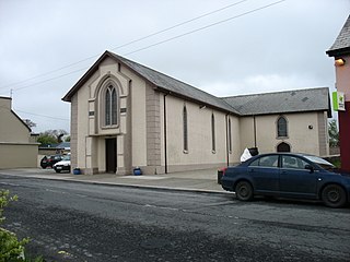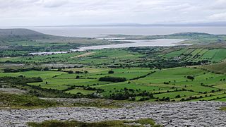
Kilkee is a small coastal town in County Clare, Ireland. It is in the parish of Kilkee, formerly Kilfearagh. Kilkee is midway between Kilrush and Doonbeg on the N67 road. The town is popular as a seaside resort. The horseshoe bay is protected from the Atlantic Ocean by the Duggerna Reef.

Kilrush is a coastal town in County Clare, Ireland. It is also the name of a civil parish and an ecclesiastical parish in Roman Catholic Diocese of Killaloe. It is located near the mouth of the River Shannon in the south-west of the county. Kilrush is one of the listed Heritage Towns of Ireland. The area was officially classified as part of the West Clare Gaeltacht, an Irish-speaking community, until 1956.

Malin Head is the most northerly point of mainland Ireland, located in the townland of Ardmalin on the Inishowen peninsula in County Donegal. The head's northernmost point is called Dunalderagh at latitude 55.38ºN. It is about 16 km (10 mi) north of the village of Malin. The island of Inishtrahull is further north, about 10 km (6 mi) northeast of the headland. Malin Head gives its name to the Malin sea area. There is a weather station on the head, which is one of 22 such stations whose reports are broadcast as part of the BBC Shipping Forecast. A tower built in 1805 is on Altnadarrow, also known locally as the Tower Hill.

Tory Island, or simply Tory, is an island 14.5 kilometres off the north-west coast of County Donegal, Ireland, and is the most remote inhabited island of Ireland. The name means "place of steep rocky heights".

Cree or Creegh is a small village in County Clare in Ireland. It is situated at a crossroads near the towns of Doonbeg and Cooraclare In the west of the county. The nearest large towns are Kilrush and Ennis which are 7 and 26 miles away respectively. The Central Statistics Office 2006 census put the population of Cree and its townlands at 457. In Dromheilly Cree there is a holy shrine located which every year in August has a week of masses that people from west Clare attend. Cree is in the Cree/Cooraclare parish and in the diocese of Killaloe. Nearby villages and small towns include Cooraclare, Doonbeg, Mullagh, Quilty, Kilmihil, Kilkee and Milltown Malbay.

Naul, is a village, townland, and civil parish at the northern edge of Fingal and the traditional County Dublin in Ireland. The Delvin River to the north of the village marks the county boundary with County Meath. Naul civil parish is in the historic barony of Balrothery West.
Ballynacally is a village and townland situated 16.7 km (10.4 mi) southwest of Ennis, on the R473 coast road to Kilrush in the civil parish of Kilchreest, County Clare, Ireland. It lies near the bank of the River Shannon.

Portnablagh is a small village in County Donegal, Ireland. Portnablagh is located on the north-west coast of County Donegal, specifically the west side of Sheephaven Bay. It is on the N56 road.

Doonbeg is a village in west County Clare, Ireland on the Atlantic coast. The surrounding natural environment has supported its development as a tourist resort. The area was officially classified as part of the West Clare Gaeltacht, an Irish-speaking community, until 1956.

Quilty, historically Killty, is a small fishing village between Milltown Malbay and Doonbeg in County Clare, Ireland. Lobster, salmon, bass, herring and mackerel are landed at Quilty, formerly known for its curing industry. The area was officially classified as part of the west Clare Gaeltacht, an Irish-speaking community, until 1956.
Shannon Gaels is the GAA club of Kilmurry McMahon/Labasheeda, County Clare. The name Shannon Gaels first appeared in 1940 but Gaelic Football has been played in the parish since 1887 under different names.
Kiltenanlea or Kiltonanlea is a civil parish in County Clare, Ireland.

Doonbeg (Killard) is a civil parish on the Atlantic coast of County Clare in Ireland. It is also an ecclesiastical parish in the Roman Catholic Diocese of Killaloe. The largest population centre in the parish is the village of Doonbeg.

Kilballyowen is the name of both a civil parish and a townland within that parish in County Clare, Ireland. The name is also occasionally used for the slightly larger Catholic parish of Cross.

Oughtmama is a civil parish in County Clare. It lies in the Burren, a region in the northwest of the county. It contains many antiquities, including three early-medieval Christian churches, ruined castles, prehistoric cairns and ring forts and two Martello Towers built in the early 19th century.
Kilfintinan is a civil parish in County Clare, Ireland. It is part of the Catholic parish of Cratloe.

Drumcreehy or Dromcreehy is a civil parish in County Clare, Ireland. It contains the village of Ballyvaughan.

Kilkee, formerly Kilfearagh, is a parish in the Roman Catholic Diocese of Killaloe located in County Clare, Ireland. It lies on the Loop Head peninsula between the Atlantic ocean and the Shannon Estuary. The main settlement is the resort town of Kilkee. The parish contains many ruins, some dating to the early days of Christianity in Ireland.
Ardnurcher is a civil parish in County Westmeath, Ireland. It is located about 19.89 kilometres (12 mi) south–west of Mullingar.


