Bamingui-Bangoran National Park and Biosphere Reserve

Last updated
Bamingui-Bangoran National Park
Central African Republic relief location map.jpg
Red pog.svg
Location Central African Republic
Coordinates 8°11′N20°14′E / 8.183°N 20.233°E / 8.183; 20.233 [1]
Area11,191 km2 (4,321 sq mi)
Established1933

The Bamingui-Bangoran National Park complex is a national park and biosphere reserve located in the northern region of the Central African Republic. It makes up part of the Guinea-Congo Forest biome. [2] The Vassako Bolo Strict Nature Reserve is in the midst of the park. [3]

Contents

Geography

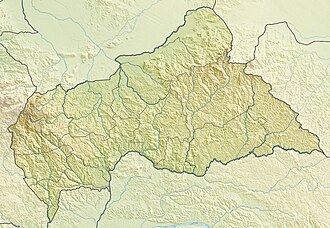
The park and biosphere reserve complex is located in the country's centre-north, west of N'Délé and close to the border with Chad. [2] Reachable from Bangui, the capital city, it is situated to the west of Manovo-Gounda St. Floris National Park, [4] and holds a higher density and a larger number of wild animals than Manovo-Gounda. [3]

The national park is 1,070,000 ha in size, and lies within the mid-Sudanian phytogeographic domain of the Central African Republic. [5] The park is situated on a plateau at an elevation of 400 metres (1,300 ft) to 500 metres (1,600 ft) above sea level. Its waterways drain north-westwards to the Chari River. [6] The left bank floodplain of the Bamingui River is protected for 202 kilometres (126 mi) as are 105 kilometres (65 mi) of floodplain on the Bangoran River. A relatively small section, approximately 30 kilometres (19 mi) section on the Bangoran's right bank, is excluded from protection. [7]

The climate includes a rainy season of May–October in the southern reaches while diminishing to June–September in the northern areas. It can be muggy all year. [4]

History

It was established in 1993. [8] In 2012, the park was captured by Séléka rebels leading to its decline. In 2018, rangers employed by Wildlife Conservation Society began patrolling the park. On 18 December 2018, park rangers clashed with rebels on hunting. One rebel was killed and the other three fled. [9]

Flora and fauna

Bamingui-Bangoran's major ecosystem is characterized as tropical dry or deciduous forests while the major habitats and land covers are dry forests, wooded savannas, edaphic savannas, and gallery forests. [10] Trees include the Terminalia, Isoberlinia doka and Anogeissus. [11]

Red faced lovebird Agapornis pullarius.jpg
Red faced lovebird

The sub-specific endemism seen in the large mammals appears to link to Chari-Logone River system Pleistocene isolation. [5] One mammal is considered endangered, the Chadian wild dog, while the Sudan cheetah, Central African lion, and African manatee are classified as vulnerable. According to Spinage, antelope populations have declined markedly since 1960 within the park. [11]

The park was also a stronghold for the now extinct Western Black Rhinoceros in the Central African Republic, but has been extinct in the country since 1986.

The park reserve's amphibians include the Mascarene ridged frog, sharp-nosed ridged frog, Schilluk ridged frog, Galam white-lipped frog, cryptic sand frog, ornate frog, crowned bullfrog, flat-backed toad, shovelnose frog, Senegal kassina, and Natal puddle frog. [1] The red faced lovebird is found here and in Nigeria's Gashaka Gumti National Park. [12]

Threats

Ecological threats to the park reserve include foreign timber and mining concessions, poaching, and agriculture land-clearance. [4]

Related Research Articles

<span class="mw-page-title-main">Bamingui-Bangoran</span> Prefecture of the Central African Republic

Bamingui-Bangoran is one of the 16 prefectures of the Central African Republic. It covers an area of 58,200 km² and had a population of 38,437 as of the 2003 census. The population density of 0.66/km² is the lowest in the country. The capital is Ndélé.

<span class="mw-page-title-main">Giant eland</span> An open-forest and savanna antelope of the family Bovidae

The giant eland, also known as the Lord Derby's eland and greater eland, is an open-forest and savanna antelope. A species of the family Bovidae and genus Taurotragus, it was described in 1847 by John Edward Gray. The giant eland is the largest species of antelope, with a body length ranging from 220–290 cm (87–114 in). There are two subspecies: T. d. derbianus and T. d. gigas.

<span class="mw-page-title-main">Kob</span> Species of mammal

The kob is an antelope found across Central Africa and parts of West Africa and East Africa. Together with the closely related reedbucks, waterbucks, lechwe, Nile lechwe, and puku, it forms the Reduncinae tribe. Found along the northern savanna, it is often seen in Murchison Falls and Queen Elizabeth National Park, Uganda; Garamba and Virunga National Park, and the Democratic Republic of the Congo, as well as grassy floodplains of South Sudan. Kob are found in wet areas, where they eat grasses. Kob are diurnal, but inactive during the heat of the day. They live in groups of either females and calves or just males. These groups generally range from five to 40 animals.

<span class="mw-page-title-main">Oribi</span> Species of mammal

The oribi is a small antelope found in eastern, southern and western Africa. The sole member of its genus, it was described by the German zoologist Eberhard August Wilhelm von Zimmermann in 1783. While this is the only member in the genus Ourebia, eight subspecies are identified. The oribi reaches nearly 50–67 centimetres (20–26 in) at the shoulder and weighs 12–22 kilograms (26–49 lb). It possesses a slightly raised back, and long neck and limbs. The glossy, yellowish to rufous brown coat contrasts with the white chin, throat, underparts and rump. Only males possess horns; the thin, straight horns, 8–18 centimetres (3.1–7.1 in) long, are smooth at the tips and ringed at the base.

<span class="mw-page-title-main">Waza National Park</span> National park in Cameroon

Waza National Park is a national park in the Department of Logone-et-Chari, in Far North Region, Cameroon. It was founded in 1934 as a hunting reserve, and covers a total of 1,700 km2 (660 sq mi). Waza achieved national park status in 1968, and became a UNESCO biosphere reserve in 1979.

<span class="mw-page-title-main">Manovo-Gounda St. Floris National Park</span> National Park in Central African Republic

Manovo-Gounda St. Floris National Park is a national park and UNESCO World Heritage Site located in the Central African Republic prefecture Bamingui-Bangoran, near the Chad border. It was inscribed to the list of World Heritage Sites in 1988 as a result of the diversity of life present within it.

<span class="mw-page-title-main">East Sudanian savanna</span> Tropical savanna ecoregion in Africa

The East Sudanian savanna is a hot, dry, tropical savanna ecoregion of Central and East Africa.

Odzala-Kokoua National Park is a national park in the Republic of the Congo. The park was first protected in 1935, declared a biosphere reserve in 1977, and granted official designation by presidential decree in 2001. Odzala-Kokoua has approximately 100 mammals species, and one of the continent's most diverse primate populations. The nonprofit conservation organization African Parks began managing the park in collaboration with the Ministry of Forest Economy, Sustainable Development and Environment of the Republic of the Congo in 2010.

Bamingui is a town and sub-prefecture in the Bamingui-Bangoran Prefecture in the northern Central African Republic. It lies on the south bank of the Chari River along National Route 8, 529 kilometres (329 mi) by road northeast of the capital of Bangui. As of 2003 it had a population of 6230 people.

Garba or Ngarba is a village in the Bamingui-Bangoran Prefecture in the northern Central African Republic.

Gounda is a village in the Bamingui-Bangoran Prefecture in the northern Central African Republic.

<span class="mw-page-title-main">Bénoué National Park</span> Natural park in Cameroon

Bénoué National Park is a national park of Cameroon and a UNESCO designated Biosphere Reserve. It is 180,000 ha in size. The park has a wide frontage to the Bénoué River, which stretches for over 100 km (62 mi), forming the eastern boundary. The public road to Tcholliré cuts across the northern part of the park. The western boundary is made up of the main road linking the towns of Garoua to the north, with Ngaoundéré to the south. The park can be accessed coming north from Ngaoundéré.

Under UNESCO’s Man and the Biosphere Programme (MAB), there are 70 biosphere reserves recognized as part of the World Network of Biosphere Reserves in African states as of 2016. These are distributed across 28 countries. While biosphere reserves in West African, East African, Central African and Southern African countries are organised in the AfriMAB regional network, biosphere reserves in Northern African countries are organised in the ArabMAB, UNESCO's regional MAB network.

<span class="mw-page-title-main">Gashaka Gumti National Park</span> National park

Gashaka-Gumti National Park (GGNP) is a national park in Nigeria, It was gazetted from two game reserves in 1991 and is Nigeria's largest national park. It is located in the eastern provinces of Taraba and Adamawa to the border with Cameroon. The total area covers about 6,402 km2, much of the northern GGNP is savannah grassland, while the southern GGNP sector of the park has a rugged terrain characterized by very mountainous, steep slopes as well as deep valleys and gorges, and is home to montane forests. Altitude ranges from ranging from about 457 metres (1,499 ft) in the northern flatter corner of the park, up to 2,419 metres (7,936 ft) at Chappal Waddi, Nigeria's highest mountain in the park's southern sections. It is an important water catchment area for the Benue River. There is abundant river flow even during the markedly dry season. Enclaves for local Fulani pastoralists exist within the park boundary that allow for farming and grazing.

<span class="mw-page-title-main">Wildlife of the Central African Republic</span>

The wildlife of the Central African Republic is in the vast natural habitat in the Central African Republic (CAR) located between the Congo Basin's rain forests and large savannas, where the human density was smaller than 0.5 per km2 prior to 1850. The forest area of 22.755 million, considered one of the richest storehouses of wildlife spread over national parks, hunting reserves and community hunting areas, experienced an alarming loss of wildlife because of greed for ivory and bushmeat exploitation by hunters – mostly Arab slavers from across the borders of the Central African Republic with Chad and Sudan.

The Vassako Bolo Strict Nature Reserve is an 860-square-kilometre (330 sq mi) nature reserve within Bamingui-Bangoran National Park and Biosphere Reserve in the northern region of the Central African Republic. It is located near the town of N'Délé, Bamingui-Bangoran prefecture. It was gazetted in 1960.

References

  1. 1 2 "Overview of Bamingui-Bangoran". bioval.jrc.ec.europa.eu. APAAT. Oct 28, 2010. Archived from the original on 23 March 2012. Retrieved 23 April 2011.
  2. 1 2 "Central African Republic (CAR) Important Bird Areas". africanbirdclub.org. Archived from the original on 28 July 2011. Retrieved 23 April 2011.
  3. 1 2 Bouché, P.; Renaud, P.-C.; Lejeune, P.; Vermeulen, C.; Froment, J.-M.; Bangara, A.; Fiongai, O.; Abdoulaye, A.; Abakar, R. & Fay, M. (2010). "Has the final countdown to wildlife extinction in Northern Central African Republic begun?". African Journal of Ecology. 48 (4): 994–1003. doi:10.1111/j.1365-2028.2009.01202.x . Retrieved 23 April 2011.
  4. 1 2 3 "Bamingui-Bangoran National Park and Biosphere Reserve". naturesstrongholds.com. Archived from the original on 23 March 2012. Retrieved 23 April 2011.
  5. 1 2 Spinage, C. A. (1988). "First steps in the ecology of the Bamingui-Bangoran National Park, Central African Republic". African Journal of Ecology. 26 (2): 73–88. doi:10.1111/j.1365-2028.1988.tb00959.x.
  6. "CF003 Bamingui-Bangoran National Park complex". Birdlife. Retrieved 23 April 2011.
  7. Hughes, R. H.; Hughes, J. S. (1992). A directory of African wetlands. IUCN. pp. 486–. ISBN   978-2-88032-949-5 . Retrieved 23 April 2011.
  8. "Bamingui Bangoran National Park". protectedplanet.net. Retrieved 23 April 2011.
  9. Central Africa’s Rangers Are as Threatened as the Animals They Guard, 6 October 2019
  10. "Biosphere Reserve Information Central African Republic BAMINGUI-BANGORAN". UNESCO. 2000-02-14. Retrieved 23 April 2011.
  11. 1 2 East, Rod (1 January 1990). Antelopes: Part 3 – West and Central Africa: Global Survey And Regional Action Plans. IUCN. pp. 102, 104–. ISBN   978-2-8317-0016-8 . Retrieved 23 April 2011.
  12. Forshaw, Joseph M.; Knight, Frank (27 September 2010). Parrots of the World. Princeton University Press. pp. 154–. ISBN   978-0-691-14285-2 . Retrieved 23 April 2011.