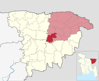
Barlekha Upazila is named after Barlekha (formerly 'Barlikha') which means Great Likha. Likha was an area historically under the Panchakhandapargana, and an ancient shloka by Mukundaram Siddhanta refers to the area by this name. Likha was later divided into Barlikha (Great Likha) and Chhotalikha (Little Likha); the latter of which still exists as a village within the upazila.[4]
History
The Malegarh hillock at Lathu (came to be known later as Shahbajpur), the northern tip of Barlekha Upazila, was shaken up in November 1857 after Indian rebels revolted in Meerut.[5] The soldiers of 34 Native Infantry in Chittagong revolted, looted the armoury and treasury and set army barracks on fire. These rebel soldiers, on their way to reach Manipur, pitched their tents at Malegarh. A force of 160 company soldiers under Major Byng, initially reached Protaphgarh (now in India) and then Malegarh on December 19, 1857. In that battle, Major Byng and four other company soldiers lost their lives. The mutineers retreated leaving behind twenty-six rebels including Major Sher Khan and Captain Shamsher Khan. For those who lived long enough to make it to Manipur, they were attacked not only by the company soldiers but also Kuki scouts. Ali Bakhsh of Chittagong, one of the rebels, was caught and charged of desertion, robbery and revolt. Gonjer Ali of Pratapgarh and Zamindar Gaus Ali Khan of nearby Prithimpasha were accused of helping the rebels.
According to the 2011 Census of Bangladesh, Barlekha Upazila had 44,192 households and a population of 257,620. 69,612 (27.02%) were under 10 years of age. Barlekha had a literacy rate (age 7 and over) of 52.42%, compared to the national average of 51.8%, and a sex ratio of 1071 females per 1000 males. 26,672 (10.35%) lived in urban areas.[9] Ethnic population was 6,370 (2.47%), of which Khasi were 1,813 and Santal 867.[10]
At the 1991 Bangladesh census, Barlekha had a population of 200,674, of whom 50.09% were aged 18 or older (against the national average of 48.52%). Of the population, 49.86% were male (national average of 51.48%) and 50.14% female (national average of 48.52%). The average literacy rate (measured as having 7+ years of education) was 34.6%, against the national average of 32.4%.[11] 70.59% of the population were Muslim, 28.31% Hindu, 0.92% Christian, 0.04% Buddhist, and 0.14% other beliefs. Ethnic nationals include Khasi and Santal, who have their own languages.
Manufacturing and minerals
There are 18 tea gardens in Barlekha spread over an area of 64.39km2, most of which were established by the English tea planters during the time of British Raj. Each garden has its own tea-processing factory. Tea laborers who work in the gardens were brought in the 1800s from outside of Bengal under rather questionable working conditions.[12] Sujanagar of this upazila is known for producing incense and attar (essence of flowers and Agar tree).[citation needed] For over a century, these have found markets in Middle Eastern and Far Eastern countries.[citation needed] There are about 350-400 agar attar factories in Barlekha. Agar attar is considered as liquid gold of Bangladesh.[citation needed] About 2000 litres of agar attar is produced in Barlekha every year. Cottage industries include weaving, sheetalpati, bamboo and cane work, iron work, and potteries are other works of Barlekha.
At Kesrigul, there is an abandoned oil field of Burma Eastern Oil Company. It was a fully functional oil field but had to be sealed off in 1951 following a disastrous oil flood when crude oil burst out of the well and flooded the surrounding area.
Deposit of radioactive uranium has been discovered in Haragachha Hill at Juri, and an expert team has authenticated its reserve.[13]
Economy and tourism
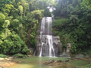
Barlekha is home to many points of interest. Madhabkunda waterfall is one of the most well-known tourist attractions in the country.[14] It is Bangladesh's largest waterfall boasting a height of 200ft (61m) and is set in a green Eco-park setting.[15] Madhabkunda is surrounded by the hills full of tea plants. Every year thousands of tourists are drawn to Madhabkunda because of its natural environment, especially in winter.[citation needed] It is about 15km from Barlekha railway station, and 350km from the city of Dhaka. Geologically, this waterfall is in the Patharia Structure and is composed of the rocks of the Bhuban Formation. Local Hindus believe the circular pool where the water falls is a magical place, and many worshippers go there every year. Although the water in the pool is not very deep, several tourists have lost their lives in Madhabkunda by the force of the water.
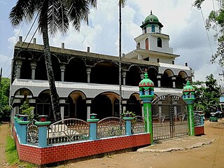
Other sites include the mausoleums of Shah Dariya Pir in Chandpur, Syed Yaqub in Horipur and Syed Abu Bakr in Chotolekha. A 16th century mosque located in Loghati, Dasher Bazar is an archaeological heritage site that continues to attract visitors.
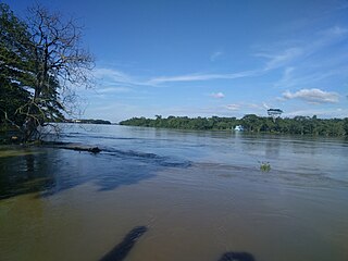
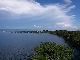
Over 40% of Hakaluki Haor, one of the largest marsh wetlands of Bangladesh as well as of Asia covering a total surface area of 181.15km2 falls within Barlekha. A very large number of nature tourists come to visit the haor each year.[16] Hakaluki Haor represents a complex wetland system with more than 80 interconnecting beels in a shallow basin formed between the Patharia and Madhab Hills to the east and the Bhatera Hills to the west. The major sources of water are the Juri, Sonai Bardhal and Kushiyara rivers, which traverse the wetland and drain through a single outlet, the Kushiyara River. While the haor itself is a seasonal water body formed during the monsoon, the beels are low-lying depressions of the haor system retaining water even during the dry months of the season. Thus, the haor system is a complex of both lacustrine wetlands (with open water) and palustrine wetlands (marshy – with vegetation), depending on the hydraulic behaviour in different seasons. In rainy season it takes the shape of a sea. Hakaluki Haor has a wide variety of waterfowl as well as wintering migratory birds.[17] Every winter, tens of thousands of guest birds of about 150 species from Siberia and other cold regions flock to the haors. They include Bright and Rose King-duck, Pati-duck, Bali Hash, Lenja, Chity, Sorali, Boikal, Nilshir Piyan, Pantamukhi, Pankouri, Buti-duck, China, Rangamuri, Black-duck, Peributhi, Chokachoki, Giria, Khonjona, Patari, Dolpipi, Water-hen, North-Giria, Dahuk, Patibatan, Common-chill, Cotton-Chill, Gergini, Cottontail, Pintail, Toughed Duck.
Hakaluki Haor presents a unique type of ecosystem as well as a new set of management issues. Most of the local inhabitants are in some way dependent on the wetland for their livelihood. Hakaluki Haor supports one of the largest inland fisheries in Bangladesh. It is one of the so-called ‘mother fishery areas’, i.e. areas where brood, young and juvenile fish aggregate and take refuge during the dry season when the rest of the haor area becomes dry. While the area was once known as a "fishmine", its fish stocks are now increasingly threatened. Hakaluki Haor is on a global level a very important wetland for a wide variety of waterfowl, particularly Anatidae ducks. In the 1960s, the wintering population of ducks was estimated at between 40,000 and 60,000.Every year a lot of birds making their nest in the house of Late Haji Monuhor Ali Master's house. This house became very well known as Masterer Pakir Bari which is a popular tourist attraction to the naturalist. Everyday a lot of local and international tourists visit Masterer Pakir Bari. In Hakaluki Haor threatened species such as Pallas’ Fish Eagle also occurs at the wetland, which is furthermore an important area for reptiles such as freshwater turtles, and for amphibians.[18][19][20]
Administration
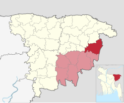
Barlekha Upazila is divided into Barlekha Municipality and ten union parishads: Baralekha, Borni, Dakshin Dakshinbhag, Dakshin Shahbazpur, Dasherbazar, Nizbahadurpur, Sujanagar, Talimpur, Uttar Dakshinbhag, and Uttar Shahbazpur. The union parishads are subdivided into 139 mauzas and 269 villages.[21]
Barlekha Municipality is subdivided into 9 wards and 27 mahallas.[21]
Education
Jamia Islamia Darul Ulum Azimganj
Barlekha City School
Shatma Adarsho Govt Primary School
Siddique Ali High School was established at 1927
Patharia Chotolekha (P. C.) Govt High School
Barlekha Girls' High School was established in the 1960s
Sylhet Division is the northeastern division of Bangladesh. It is bordered by the Indian states of Meghalaya, Assam and Tripura to the north, east and south respectively, and by the divisions of Chittagong to the southwest and Dhaka and Mymensingh to the west.
Moulvibazar, also spelled Moulabhibazar,Maulvibazar, Moulavibazar, and Maulavibazar, is the southeastern district of Sylhet Division in northeastern Bangladesh, named after the town of Moulvibazar. It is bordered by the Indian states of Tripura and Assam to the south and east, respectively; by the Bangladeshi districts of Habiganj to the west and Sylhet to the north.
Netrokona is a district of the Mymensingh Division in north-east of Bangladesh.
Kamalganj is an upazila of the Moulvibazar District in the Division of Sylhet, Bangladesh.
Kulaura, is the biggest upazila (subdistrict) of the Moulvibazar District in north-eastern Bangladesh. The total area of this upazila is 545 km2. Hakaluki Haor, the largest marsh wetland in Sylhet Division and one of the largest in Bangladesh is partially located there.
Rajnagar is an upazila of the Moulvibazar District in Sylhet Division, Bangladesh. The district has roughly 43,070 houses and an area of approximately 340 km2. There are three well-known rivers which flow across the Upazila border side of Rajnagar: the Kushiara in the North, the Manu across the southern three unions, and the Dholai across Kamarchak and the southern border.
Sreemangal is an upazila of Moulvibazar District. in Sylhet Division, Bangladesh. It is located at the southwest of the district, and borders the Habiganj District to the west and the Indian state of Tripura to the south. Sreemangal is often referred to as the 'tea capital' of Bangladesh, and is most famous for its tea fields. Other than tea, the rubber, pineapple, wood, betel, and lemon industries also exist in the upazila.
Dharmapasha (Bengali: ধর্মপাশা, romanized: Dhormopasha, also spelled as Dharampasha or Dharamapasha, is an upazila of Sunamganj District in the Division of Sylhet, Bangladesh.
Balaganj is an upazila of Sylhet District in Sylhet Division, Bangladesh.
Beanibazar is an upazila (sub-district) of Sylhet District in northeastern Bangladesh, part of the Sylhet Division. The area is the successor of the territory of Panchakhanda, formerly ruled by the aristocratic Pal family.
Fenchuganj is an upazila of Sylhet District in the Division of Sylhet, Bangladesh.
Madhabkunda Waterfall is one of the highest waterfalls in Bangladesh. Situated in Barlekha Upazila of Moulvibazar District, the waterfall is a popular tourist spot in Bangladesh. The forest, streams, and ecological park in the vicinity attract numerous tourists for picnics and day trips.
Juri is an upazila of the Moulvibazar District. In 2001, its population was 122,853. It is located 48 km from District headquarters. The local high school was established in 1930.
A haor is a wetland ecosystem in the north eastern part of Bangladesh which physically is a bowl or saucer shaped shallow depression, also known as a backswamp. During monsoons haors receive surface runoff water from rivers and canals to become vast stretches of turbulent water.
Hakaluki Haor is a marsh wetland ecosystem of north-eastern Bangladesh. It is one of Bangladesh's largest and one of Asia's large marsh wetland resources. Hakaluki Haor is bounded by the Kushiara river as well as a part of the Sonai Bardal river to the north, by the Fenchuganj-Kulaura railway to the west and to the south, and by the Kulaura-Beanibazar road the east. It lies between 24°35’ N to 24°44’ N and 92°00’ E to 92°08’ E.
An Ecologically Critical Area (ECA) is an environmental protection zone in Bangladesh. In 1995, specific areas in Bangladesh could be deemed Ecologically Critical Areas as a result of the Environmental Conservation Act.
Osmani Nagar is an upazila of Sylhet District in the Division of Sylhet, Bangladesh.
The economy of Sylhet is the 5th largest in the Peoples Republic of Bangladesh. It has a gross state product of $16 billion in nominal terms, and $40 billion in terms of purchasing power parity, making it the third largest behind Dhaka, Chittagong, Khulna and Rajshahi. Since the formation of Bangladesh, Sylhet has been regarded as the spiritual and cultural center of the country, and often termed as the agricultural capital of Bangladesh. Due to vast natural resources and emerging metropolitan, Sylhet is a major economic hub of the country alongside Dhaka and Chittagong. In recent years, Sylhet is experiencing major infrastructural developments, and projected to be the forefront of Bangladesh's economic growth. Sylhet is known for its tea plantations. About 80% of the country's agar processing factories are located in Barlekha Upazila.
Shantiganj (Bengali: শান্তিগঞ্জ, romanized: Shantigônj, formerly known as South Sunamganj or Dakshin Sunamganj (Bengali: দক্ষিণ সুনামগঞ্জ, is an upazila of the Sunamganj District in Sylhet Division, Bangladesh.
Kala Pahar, also known as Debbarma Haphong in Khasi, is the highest peak of northern Bangladesh. Located near Robir bazar of Kulaura Upazila in Moulvibazar District, it is only 3–4 hours trekking distance from Azgarabad Tea Estate. This peak is also accessible from Rajki tea estate near Fultola bazar of Juri Upazila. The hill range of Kala Pahar is locally known as Longla Range. 'Kala Pahar' is the local name of the highest peak. According to Bangladesh Geographic society this hill is also known as 'Hararganj pahar'. In Bengali language 'hill' word means 'Pahar'. Situated in the north-eastern part of the country 60% of the range is in Bangladesh and the rest is in the Northern Tripura state of India. In Tripura, part of this hill is known as Raghunandan pahar. The famous ancient religious archaeological site of India 'Unakoti' lies at the foot of this hill. Kala Pahar is about 1,100 feet high from the sea level. In November 2015, members of a local adventure group of Bangladesh BD Explorer explored this peak and measured the highest point as 1,098 feet with a Garmin handheld GPS. During autumn, if the sky is clear, one can observe the blue water of Hakaluki haor(Largest haor of Bangladesh) from the high point of Kala Pahar. There are some Khasi establishments adjacent to this hill, such as Nunchora punji, Panaichora punji, Putichora punji and Baigonchora punji.
↑ "Bangladesh Postal Code". Dhaka: Bangladesh Postal Department under the Department of Posts and Telecommunications of the Ministry of Posts, Telecommunications and Information Technology of the People's Republic of Bangladesh. 20 October 2024.
This page is based on this Wikipedia article Text is available under the CC BY-SA 4.0 license; additional terms may apply. Images, videos and audio are available under their respective licenses.