Barnsley, Manitoba

Last updated

Barnsley
Grain Elevators at Barnsley, Manitoba.JPG
Manitoba Co-operative Elevator Association and United Grain Growers Elevators at Barnsley
Canada Manitoba location map 2.svg
Red pog.svg
Barnsley
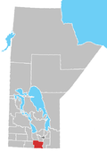
Location of Barnsley in Manitoba
Coordinates: 49°35′31″N97°59′24″W / 49.59194°N 97.99000°W / 49.59194; -97.99000
Country Flag of Canada (Pantone).svg  Canada
Province Flag of Manitoba.svg  Manitoba
Region Pembina Valley
Census Division No. 3
Government
  Governing BodyRural Municipality of Dufferin Council
   MP Branden Leslie
   MLA Blaine Pedersen
Time zone UTC−6 (CST)
  Summer (DST) UTC−5 (CDT)
Area code 204
NTS Map062H12
GNBC CodeGABRE

Barnsley is a locality in south central Manitoba, Canada. It is located approximately 10 kilometers (6 miles) north of Carman, Manitoba [1] in the Rural Municipality of Dufferin.

Related Research Articles

<span class="mw-page-title-main">Flin Flon</span> City in Manitoba and Saskatchewan, Canada

Flin Flon is a mining city, located on a correction line on the border of the Canadian provinces of Manitoba and Saskatchewan, with the majority of the city located within Manitoba. Residents thus travel southwest into Saskatchewan, and northeast into Manitoba. The city is incorporated in and is jointly administered by both provinces.

<span class="mw-page-title-main">Winnipeg Metropolitan Region</span> Metropolitan area in Manitoba, Canada

The Winnipeg Metropolitan Region is a metropolitan area in the Canadian province of Manitoba located in the Red River Valley in the southeast portion of the province of Manitoba, Canada. It contains the provincial capital of Winnipeg and 17 surrounding rural municipalities, cities, and towns.

The Rural Municipality of Albert is a former rural municipality (RM) in the Canadian province of Manitoba. It was originally incorporated as a rural municipality on December 1, 1905. It ceased on January 1, 2015 as a result of its provincially mandated amalgamation with the RM of Arthur and the RM of Edward to form the Municipality of Two Borders.

<span class="mw-page-title-main">Rural Municipality of Alexander</span> Rural municipality in Manitoba, Canada

The Rural Municipality of Alexander is a rural municipality in the Eastman Region of Manitoba, Canada. The town of Powerview-Pine Falls lies adjacent to the municipality, as does the Sagkeeng First Nation Indian reserve.

<span class="mw-page-title-main">Rivers, Manitoba</span> Unincorporated community in Manitoba, Canada

Rivers is an unincorporated urban community in the Riverdale Municipality within the Canadian province of Manitoba. It is located 40 kilometres (25 mi) northwest of Brandon, 473 metres (1,552 ft) above sea level. It is within the Westman Region. Agriculture, health and related businesses provide income for the community and area. Rivers has a population of 1,257 people in the 2016 census.

<span class="mw-page-title-main">Rural Municipality of St. Clements</span> Rural municipality in Manitoba, Canada

St. Clements is a rural municipality (RM) in Manitoba, Canada. It is located to the north-east of Winnipeg, stretching from East St. Paul and Birds Hill Provincial Park in the south to Lake Winnipeg and Grand Beach Provincial Park to the north. The Red River demarcates the western boundary of the municipality. St. Clements contains the communities of East Selkirk, and Lockport east of the Red River. It almost completely surrounds the Brokenhead 4 Indian reserve, with the exception of a small lakefront on Lake Winnipeg.

<span class="mw-page-title-main">Rural Municipality of Springfield</span> Rural municipality in Manitoba, Canada

Springfield is a rural municipality (RM) in Manitoba, Canada. It stretches from urban industrial development on the eastern boundary of the city of Winnipeg, through urban, rural residential, agricultural and natural landscapes, to the Agassiz Provincial Forest on the municipality's eastern boundary. Birds Hill Provincial Park nestles into the north-western corner of Springfield.

<span class="mw-page-title-main">Rural Municipality of Macdonald</span> Rural Municipality in Southern Manitoba

Macdonald is a rural municipality lying adjacent to the southwest side of Winnipeg, Manitoba, Canada. It is part of the Winnipeg Metro Region, but is not part of the smaller Winnipeg census metropolitan area. Macdonald's population as of the 2016 census was 7,162.

<span class="mw-page-title-main">Somerset, Manitoba</span> Place in Manitoba, Canada

Somerset is an unincorporated community recognized as a local urban district in the Municipality of Lorne within the Canadian province of Manitoba that held village status prior to January 1, 2015.

<span class="mw-page-title-main">Demographics of Manitoba</span>

Manitoba is one of Canada's 10 provinces. It is the easternmost of the three Prairie provinces.

<span class="mw-page-title-main">Rural Municipality of Thompson</span> Rural municipality in Manitoba, Canada

Thompson is a rural municipality (RM) in the Pembina Valley Region of Manitoba, Canada. It had a population of 1,259 according to the Canada 2006 Census.

<span class="mw-page-title-main">Municipality of Killarney-Turtle Mountain</span> Rural municipality in Manitoba, Canada

Killarney-Turtle Mountain is a rural municipality (RM) located in the Westman Region of Manitoba, Canada. It is located to the immediate north of the Canada–United States border opposite Rollete and Towner Counties, North Dakota.

<span class="mw-page-title-main">Rural Municipality of La Broquerie</span> Rural municipality in Manitoba, Canada

La Broquerie is a rural municipality in the province of Manitoba in Western Canada, located in the southeastern part of the province, just south and east of the city of Steinbach.

<span class="mw-page-title-main">Rural Municipality of Brokenhead</span> Rural municipality in Manitoba, Canada

The Rural Municipality of Brokenhead is a rural municipality (RM) in the Canadian province of Manitoba.

Napinka is an unincorporated community in southwestern Manitoba, Canada. The village of Napinka was incorporated on May 1, 1908. On January 1, 1986 the village dissolved and Napinka became part of the Rural Municipality of Brenda.

<span class="mw-page-title-main">Riverdale Municipality</span> Rural municipality in Manitoba, Canada

Riverdale Municipality is a rural municipality (RM) in the Canadian province of Manitoba.

References

  1. "Querying Canadian Geographical Names | Earth Sciences". Archived from the original on April 16, 2014. Retrieved May 20, 2012.