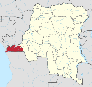
Kongo Central, formerly Bas-Congo, is one of the 26 provinces of the Democratic Republic of the Congo. Its capital is Matadi.

Bandundu is one of eleven former provinces of the Democratic Republic of the Congo. It bordered the provinces of Kinshasa and Bas-Congo to the west, Équateur to the north, and Kasai-Occidental to the east. The provincial capital is also called Bandundu.

Équateur was one of the eleven provinces of the Democratic Republic of the Congo between 1966 and 2015, when it was split into the new, smaller Équateur province, as well as the Tshuapa, Mongala, Nord-Ubangi and Sud-Ubangi provinces.

Orientale is one of the eleven former provinces of the Democratic Republic of the Congo. The province lay in the northeast of the country. It bordered Équateur to the west, Kasaï-Oriental province to the southwest, Maniema to the south, and North Kivu to the southeast. It also bordered the Central African Republic and South Sudan to the north, and Uganda to the east. The provincial capital is Kisangani.

Buta is a city in the northern Democratic Republic of the Congo, lying on the Rubi River, a tributary of the Itimbiri River. It is the capital of Bas-Uele province. As of 2009, it had an estimated population of 50,130.

Bikoro is a market town in Équateur Province in the Democratic Republic of the Congo, lying on Lake Tumba, south of Mbandaka.
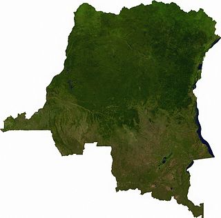
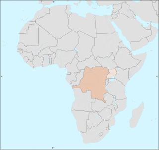
Articles related to the Democratic Republic of the Congo include:
Bondo is a town in north-central Democratic Republic of the Congo, in Bas-Uele Province, about 200 km north-west of Buta. Bondo lies mainly on the north bank of the Uele River. As of 2009 it had an estimated population of 19,601.
Aketi Territory is a territory in the Bas-Uele Province of the Democratic Republic of the Congo. The administrative capital is located at Aketi. The territory borders Bondo Territory to the north, Buta Territory to the east, Basoko Territory to the south, Bumba Territory to the west in Mongala Province and Yakoma Territory in Nord-Ubangi Province to the northwest. Rivers include the Likati River, Zoki River, Maze River, Tinda River, Tshimbi River, Elongo River, Aketi River, Yoko River and Lese River along the southern territorial border.
Bondo Territory is a territory in the Bas-Uele Province of the Democratic Republic of the Congo. The administrative capital is the town of Bondo.
Buta Territory is a territory in Bas-Uele District, Orientale Province, Democratic Republic of the Congo. The administrative capital is located at Buta.

Haut-Uele is one of the 26 provinces of the Democratic Republic of the Congo. Its capital is Isiro. The district takes its name, which means "upper Uele" in French, from the Uele River.

Tshopo is one of the 26 provinces of the Democratic Republic of the Congo. It is situated in the northeast of the country on the Tshopo River, for which it is named. Its capital is Kisangani.
Mongala is one of the 26 provinces of the Democratic Republic of the Congo. Its capital is the town of Lisala.

Kwango is one of the 26 provinces of the Democratic Republic of the Congo. Its capital is Kenge. It takes its name from the Kwango River, a tributary of the Kasai River that defines the international boundary between the DRC and Angola.

In 2014, an outbreak of Ebola virus disease in the Democratic Republic of the Congo (DRC) occurred. Genome sequencing has shown that this outbreak was not related to the 2014–15 West Africa Ebola virus epidemic, but was of the same EBOV species. It began in August 2014 and was declared over in November of that year, after 42 days without any new cases. This is the 7th outbreak there, three of which occurred during the period of Zaire.
The Democratic Republic of the Congo (DRC) was identified by the World Health Organization (WHO) on 11 May 2017 as having one Ebola-related death.

The 2018 Équateur province Ebola outbreak occurred in the north-west of the Democratic Republic of the Congo (DRC) from May to July 2018. It was contained entirely within Équateur province, and was the first time that vaccination with the rVSV-ZEBOV Ebola vaccine had been attempted in the early stages of an Ebola outbreak, with a total of 3,481 people vaccinated. It was the ninth recorded Ebola outbreak in the DRC.
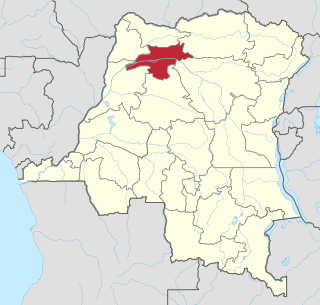
Likati is a district in the Bas-Uélé Province in the north of the Democratic Republic of the Congo (DRC). It was the site of an outbreak of Ebola virus disease in 2017. According to the World Health Organization, it is situated in the remote, isolated and hard-to-reach northern part of DRC, with limited transport and communication networks.
The Kivu Ebola epidemic began on 1 August 2018, when it was confirmed that four cases had tested positive for Ebola virus disease (EVD) in the eastern region of Kivu in the Democratic Republic of the Congo (DRC). The Kivu outbreak includes Ituri Province, after the first case was confirmed on 13 August, and in June 2019, the virus reached Uganda, having infected a 5-year-old Congolese boy who entered Uganda with his family, but was contained. In November 2018, the outbreak became the biggest Ebola outbreak in the DRC's history, and by November, it had become the second-largest Ebola outbreak in recorded history, behind only the 2013–2016 Western Africa epidemic. On 3 May 2019, nine months into the outbreak, the DRC outbreak death toll surpassed 1,000.
