Related Research Articles

Sullivan's Island, historically known as O'Sullivan's Island, is a town and island in Charleston County, South Carolina, United States, at the entrance to Charleston Harbor, with a population of 1,791 at the 2010 census, and 1,891 people in 2020. The town is part of the Charleston metropolitan area, and is considered a very affluent suburb of Charleston.

The Ashley River is a blackwater and tidal river in South Carolina, rising from the Wassamassaw and Great Cypress Swamps in western Berkeley County. It consolidates its main channel about five miles west of Summerville, widening into a tidal estuary just south of Fort Dorchester. The river then flows for approximately 17 mi (27 km) along the historical banks of the City of North Charleston before reaching peninsular Charleston. The much wider Ashley joins the Cooper River off the Battery in Charleston to form Charleston Harbor before discharging into the Atlantic Ocean. As of 2012 the land around the Ashley River is mostly undeveloped.
The Cherokee Path was the primary route of English and Scots traders from Charleston to Columbia, South Carolina in Colonial America. It was the way they reached Cherokee towns and territories along the upper Keowee River and its tributaries. In its lower section it was known as the Savannah River. They referred to these towns along the Keowee and Tugaloo rivers as the Lower Towns, in contrast to the Middle Towns in Western North Carolina and the Overhill Towns in present-day southeastern Tennessee west of the Appalachian Mountains.

Middleton Place is a plantation in Dorchester County, along the banks of the Ashley River west of the Ashley and about 15 miles (24 km) northwest of downtown Charleston, in the U.S. state of South Carolina. Built in several phases during the 18th and 19th centuries, the plantation was the primary residence of several generations of the Middleton family, many of whom played prominent roles in the colonial and antebellum history of South Carolina. The plantation, now a National Historic Landmark District, is used as a museum, and is home to the oldest landscaped gardens in the United States.

West Ashley, or more formally, west of the Ashley, is one of the six distinct areas of the city proper of Charleston, South Carolina. As of July 2022, its estimated population was 83,996. Its name is derived from the fact that the land is west of the Ashley River.

The large, neoclassical Simmons-Edwards House is a Charleston single house built for Francis Simmons, a Johns Island planter, about 1800. The house, located at 14 Legare St., Charleston, South Carolina, is famous for its large brick gates with decorative wrought iron. The gates, which were installed by George Edwards and which bear his initials, include finials that were carved to resemble Italian pinecones. They are frequently referred to as pineapples by locals, and the house is known popularly as the Pineapple Gates House.

Mulberry Plantation is a historic plantation property in rural Berkeley County, South Carolina. Located between Moncks Corner and Charleston, this property was developed in 1714 by Thomas Broughton, who became the Royal governor of South Carolina, and is one of the oldest plantation homes in the United States. Its rice fields, dikes and canals were well-preserved into the 20th century. The plantation house and ten surrounding acres were declared a National Historic Landmark in 1963.
St. Michael's AnglicanChurch is a historic church and the oldest surviving religious structure in Charleston, South Carolina. It is located at Broad and Meeting streets on one of the Four Corners of Law, and represents ecclesiastical law. It was built in the 1750s by order of the South Carolina Assembly. It is listed on the National Register of Historic Places and is a National Historic Landmark.
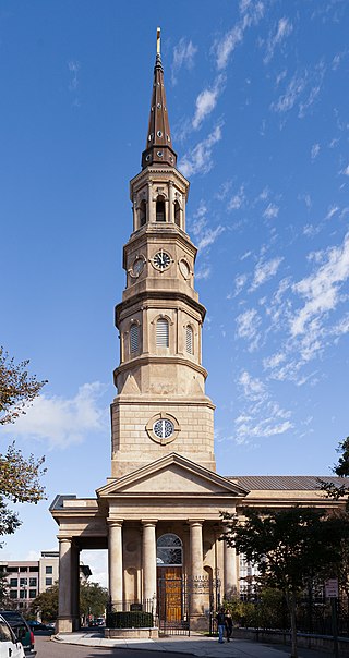
St. Philip's Church is an historic church at 142 Church Street in Charleston, South Carolina. Its National Historic Landmark description states: "Built in 1836, this stuccoed brick church features an imposing tower designed in the Wren-Gibbs tradition. Three Tuscan pedimented porticoes contribute to this design to make a building of the highest quality and sophistication." On November 7, 1973, it was added to the National Register of Historic Places and designated a National Historic Landmark.

This is a list of the National Register of Historic Places listings in Charleston County, South Carolina.

The Deptford culture was an archaeological culture in southeastern North America characterized by the appearance of elaborate ceremonial complexes, increasing social and political complexity, mound burial, permanent settlements, population growth, and an increasing reliance on cultigens.

Magnolia Cemetery is a historic rural cemetery in Charleston, South Carolina. The first board for the cemetery was assembled in 1849 with Edward C. Jones as the architect. It was dedicated in 1850; Charles Fraser delivered the dedication address. It was listed on the National Register of Historic Places as a Historic District in 1978.

This is a list of the National Register of Historic Places listings in Charleston, South Carolina.

Marshlands Plantation House, in Charleston, South Carolina, is an historic plantation house that was built in 1810 and listed in the National Register of Historic Places on March 30, 1973. It is a 2+1⁄2-story Federal-style plantation home. The house was relocated in the 1960s from its original location on the site of the United States Navy Shipyard. The Navy had announced it would have to demolish the empty house if it could not be relocated with the $15,000 the Navy had set aside for the purpose. The City of Charleston took temporary possession of the house, transferring it to the College of Charleston which relocated it for preservation to James Island.

Spanish Mount Point is a historic archaeological site located at Edisto Beach State Park, Edisto Island, Colleton County, South Carolina. Spanish Mount is an oyster-clam shell midden, about 27 meters long and 3 meters high. The site is bordered by water and marsh on three sides. Spanish Mount dates between 2200 and 1800 BC and represents a transitional period of pre-history and the midden accumulated during the site's short term occupation.

Pinckneyville is a historic frontier settlement site located near Union, Union County, South Carolina. Pinckneyville was established on February 19, 1791, by the General Assembly of South Carolina Act #1491 along with the Washington district, and is one of the earliest settlements in the South Carolina backcountry. Pinckneyville was named for Charles Cotesworth Pinckney. Pinckneyville was chosen because it was central to Union County, but Union was the seat of power.

Ashley Hall Plantation is a historic plantation complex located on the Ashley River near West Ashley, Charleston County, South Carolina. The plantation was established in the early 1670s by Stephen Bull. The property includes a small tabby-walled house with a 20th-century second story addition, the ruins of the Georgian plantation house (1704) which was burned in 1865 to prevent its destruction by Union forces, a monument to the second Governor William Bull, two prehistoric Indian archaeological sites, and two 18th century well sites associated with the plantation. The tabby house is considered one of the oldest standing houses in the state.

Willtown Bluff, also known as Wilton and New London, is a historic settlement site located on the S. Edisto River near Adams Run, Charleston County, South Carolina. Founded about 1704, it was the second planned town to be established after the relocation of Charleston in 1682. Willtown served as a local governmental center and regional commercial center. The property includes three early-19th-century buildings: the Parsonage, the Willtown Plantation House, and the remains of a single column of the Episcopal Church. Unexposed remains are of a colonial village thought to have had 80 houses.

Secessionville Historic District is a national historic district located near Folly Beach, Charleston County, South Carolina. It extends into the city of Charleston, South Carolina. The district encompasses six contributing buildings, one contributing site, and one contributing site in Secessionville. The district includes the summer homes of several leading James Island planters, the site of the American Civil War Battle of Secessionville, the unmarked grave of over 300 Union soldiers, and the remains of Fort Lamar, constructed about 1862.
References
- 1 2 "National Register Information System". National Register of Historic Places . National Park Service. July 9, 2010.
- ↑ unknown. "Bass Pond Site" (pdf). National Register of Historic Places - Nomination and Inventory. Retrieved August 3, 2014.
- ↑ "Bass Pond Site, Charleston County (Address Restricted)". National Register Properties in South Carolina. South Carolina Department of Archives and History. Retrieved August 1, 2014.
| Topics |  | |
|---|---|---|
| Lists by county |
| |
| Lists by city | ||
| Other lists | ||
| | This article about a property in Charleston County, South Carolina on the National Register of Historic Places is a stub. You can help Wikipedia by expanding it. |