Harpenden is a town and civil parish in the City and District of St Albans in the county of Hertfordshire, England. The population of the built-up area was 30,240 in the 2011 census, whilst the population of the civil parish was 29,448. Harpenden is a commuter town, with a direct rail connection through Central London and property prices well over triple the national average.

The River Wandle is a right-bank tributary of the River Thames in south London, England. With a total length of about 9 miles (14 km), the river passes through the London boroughs of Croydon, Sutton, Merton and Wandsworth, where it reaches the Thames. A short headwater – the Caterham Bourne – is partially in Surrey, the historic county of the river's catchment. Tributaries of the Wandle include Carshalton Ponds and Norbury Brook.

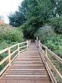
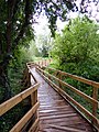
Ingrebourne Valley is a local nature reserve (LNR) in Hornchurch in the London Borough of Havering. It is owned and managed by Havering Council, and has a visitor centre managed by the Essex Wildlife Trust. Most of it is in Hornchurch Country Park west of the River Ingrebourne, but there are also areas north and south of the park which are part of the LNR. It has a wide range of habitats, including woodland, grassland, the river and marshes. It is an important site for a range of species of plants, animals and birds, including great crested newts, slow worms, the harvest mouse and the water vole.
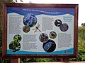
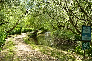
Batford is a village in Hertfordshire, England, located on the River Lea on the outskirts of Harpenden. Batford Springs is a local nature reserve alongside the river and the village green, which has a small play area for children. The large red brick building at the southern end of the village between the river and the Lower Luton Road was originally a water mill. It is now used as offices, and the river has been diverted around the building. Batford Methodist Church built in 1905 and shows the distinctive "modern" architecture of that time.

Westmill is a residential area of Hitchin in Hertfordshire, England. It was originally built as a council housing estate in the 1920s. There is a primary school, Oughton Junior, Infant and Nursery School. It forms part of Oughton ward for local government purposes.

Isleworth Ait, also known as Isleworth Eyot, is a between 3.5-hectare (8.6-acre) and 9.370-acre (3.792 ha) teardrop-shaped island in the River Thames in England. The long ait is on the Tideway facing Old Isleworth and the towpath alongside the Royal Mid-Surrey Golf Club. These places are in the London Boroughs of Hounslow and Richmond upon Thames. The island faces Heron's Place and a number of commercial buildings.

Lesnes Abbey Woods, sometimes known as Abbey Wood, is a 73 ha ancient woodland in southeast London, England. It is located near to, and named after, the ruined Lesnes Abbey in the London Borough of Bexley and gives its name to the Abbey Wood district. The woods are adjacent to Bostall Woods.

Adelaide Local Nature Reserve is in North West London, in the area of Chalk Farm, Primrose Hill, Belsize Park and Swiss Cottage. It is managed by a local volunteer group, the Adelaide Nature Reserve Association, which works with the council to improve the site for wildlife and local community use and enjoyment. The site is a Local Nature Reserve and Site of Borough Importance for Nature Conservation, Grade 1.
Wandle Meadow Nature Park is a 4.15 hectare local nature reserve and Site of Borough Importance for Nature Conservation, Grade 1, in Wimbledon in the London Borough of Merton. It is owned and managed by Merton Council.

Wandle Valley Wetland is a 0.6 hectare Local Nature Reserve in Carshalton in the London Borough of Sutton. It is owned by the Council and managed by the Council together with Sutton Nature Conservation Volunteers.

Anton Crescent Wetland is a one hectare Local Nature Reserve in Sutton in the London Borough of Sutton. It is owned by Sutton Council and managed by the council together with Sutton Nature Conservation Volunteers.

Oak Avenue is a 1.85 hectare Local Nature Reserve and Grade II Site of Borough Importance for Nature Conservation in Hampton in the London Borough of Richmond upon Thames. It is owned and managed by Richmond upon Thames Borough Council.

Chorleywood Common is a 75.6 hectare Local Nature Reserve in Chorleywood in Hertfordshire. It is owned and managed by Chorleywood Parish Council, and the declaring authority is Hertfordshire County Council. The common is part of the Chilterns Area of Outstanding Natural Beauty.
Oughtonhead Common is a 17.4 hectare Local Nature Reserve in the Westmill district of Hitchin, Hertfordshire. It is owned and managed by North Hertfordshire District Council.
Stanborough Reedmarsh is a 3.3 hectare Local Nature Reserve in Welwyn Garden City in Hertfordshire. It is owned by Welwyn Hatfield Borough Council and managed by the Herts and Middlesex Wildlife Trust.

Singlers Marsh is a 6.3 hectare Local Nature Reserve in Welwyn in Hertfordshire It is owned and managed by Welwyn Hatfield Borough Council.

The Withey Beds is a 7.5 hectare Local Nature Reserve (LNR) in Rickmansworth in Hertfordshire. It was declared an LNR in 2004 by Three Rivers District Council, and the council owns and manages the site.