London Colney is a village and civil parish in Hertfordshire, England. It is located to the north of London, close to Junction 22 of the M25 motorway.

The Colne is a river and a tributary of the River Thames in England. Just over half its course is in south Hertfordshire. Downstream, it forms the boundary between Buckinghamshire and the London Borough of Hillingdon. The confluence with the River Thames is on the Staines reach at Staines-upon-Thames.
Colney Heath is a large village in Hertfordshire, England. The village became a civil parish in 1947 when the St. Peter Rural parish was split to form Colney Heath and London Colney. There is a converted windmill in the village. The civil parish also includes the settlements of Smallford and Sleapshyde.
The River Ash is a small, shallow river in Surrey, England. Its course of 10 kilometres (6.2 mi) is just outside Greater London. Work has been carried out to re-align, clear, build up a small, Littleton head of water and create two backwaters. One backwater dates to the medieval period; the other to the 1990s decade. It flows as one of the six distributaries of the River Colne from the south of Staines Moor immediately south of the Staines Bypass eastwards through the rest of the borough of Spelthorne before meeting the River Thames.
Hounslow Heath is a local nature reserve in the London Borough of Hounslow and at a point borders Richmond upon Thames. The public open space, which covers 200 acres (80 ha), is all that remains of the historic Hounslow Heath which covered more than 4,000 acres (1,600 ha). The present day area is bounded by A315 Staines Road, A3063 Wellington Road South, A314 Hanworth Road, and the River Crane.

Hertford Heath is a village and civil parish near the county town of Hertford in Hertfordshire, England. The population at the 2011 Census was 2,672.

Batchworth was once a hamlet and is now a civil parish and part of Rickmansworth in Hertfordshire. The parish of Batchworth was created on 1 April 2017 consisting of two Three Rivers District Council wards: Rickmansworth Town, and Moor Park and Eastbury. The first election to Batchworth Parish Council was on 4 May 2017. There are eight councillors; four in each ward.

Herts and Middlesex Wildlife Trust manages over 40 nature reserves covering nearly 810 hectares north of London, in Hertfordshire and the historic county of Middlesex, part of which is divided between the London boroughs of Barnet, Enfield, Harrow and Hillingdon. It has over 21,000 members, and is one of 46 Wildlife Trusts across the UK. It is a Registered Charity, with its Registered Office in St Albans, and had an income in the year to 31 March 2014 of over £1.5 million.

Wormley is a village and former civil parish, now in the unparished area of Hoddesdon, in the Broxbourne district, in the county of Hertfordshire, England. The village is part of the census ward of Wormley and Turnford, which had a population of 8,146 at the 2001 census. In 1931 the parish had a population of 930.

Frays Farm Meadows is a 28.2-hectare (70-acre) biological Site of Special Scientific Interest near Denham in the London Borough of Hillingdon. It was notified as an SSSI in 1981, and has been managed by the London Wildlife Trust on behalf of Hillingdon Council since 1999. It is part of the Colne Valley Regional Park.

Mid Colne Valley is a 132 hectare biological Site of Special Scientific Interest in Harefield in the London Borough of Hillingdon and Denham in South Buckinghamshire. Its main importance lies in its extensive diversity of birdlife in lakes in former gravel pits.
Waterford Heath is a 35.2 hectare Local Nature Reserve in Waterford in Hertfordshire, England. It is owned by Lafarge Tarmac and managed by the Herts and Middlesex Wildlife Trust together with East Hertfordshire District Council and Lafarge.

Rickmansworth Aquadrome is a 41 hectares public park and Local Nature Reserve in Rickmansworth in Hertfordshire. It is owned and managed by Three Rivers District Council.

The Lairage Land is a 4.4 hectare Local Nature Reserve in Watford in Hertfordshire. It is owned and managed by Watford Borough Council.

The Withey Beds is a 7.5 hectare Local Nature Reserve (LNR) in Rickmansworth in Hertfordshire. It was declared an LNR in 2004 by Three Rivers District Council, and the council owns and manages the site.

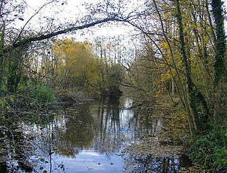
Broad Colney Lakes is an 11 hectare nature reserve previously managed by Herts and Middlesex Wildlife Trust in London Colney in Hertfordshire. It has recently been sold to an anonymous buyer but reports in The Herts Advertiser says "the selected buyer has stated that the site will continue to be used for fishing, with the woodland managed for the benefit of wildlife.” It has three lakes, created as a result of gravel extraction in the 1920s. Otters travel through Long Lake on their journeys along the River Colne, which flows through the lake, and great crested grebes nest at the edge. Small Lake is marshy and a breeding area for fish, while North Lake has tufted ducks, coots and mallards.

Marshalls Heath is a hamlet and a 4-hectare (10-acre) Local Nature Reserve in Wheathampstead parish, Hertfordshire, England. The nature reserve is owned by Wheathampstead Parish Council and managed by the council together with the Friends of Marshalls Heath. It was purchased from The Queen's College, Oxford, in 1966.

Blindley Heath SSSI is a 26.3-hectare (65-acre) biological Site of Special Scientific Interest in the hamlet Blindley Heath, on the southern outskirts of Godstone in Surrey. It is also a Local Nature Reserve. It is owned by Godstone Parish Council and managed by the Surrey Wildlife Trust

