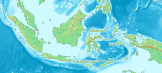
Indonesia is an archipelagic country located in Southeast Asia, lying between the Indian Ocean and the Pacific Ocean. It is located in a strategic location astride or along major sea lanes connecting East Asia, South Asia and Oceania. Indonesia is the largest archipelago in the world. Indonesia's various regional cultures have been shaped—although not specifically determined—by centuries of complex interactions with its physical environment.

Indonesia's transport system has been shaped over time by the economic resource base of an archipelago with thousands of islands, and the distribution of its more than 200 million people concentrated mainly on a single island, Java.

Sulawesi, also known as Celebes, is one of the four Greater Sunda Islands. It is governed by Indonesia. The world's eleventh-largest island, it is situated east of Borneo, west of the Maluku Islands, and south of Mindanao and the Sulu Archipelago. Within Indonesia, only Sumatra, Borneo, and Papua are larger in territory, and only Java and Sumatra have larger populations.

Central Sulawesi is a province of Indonesia located at the centre of the island of Sulawesi. The administrative capital and largest city is located in Palu. The 2010 census recorded a population of 2,635,009 for the province, and the 2020 Census recorded 2,985,734, of whom 1,534,706 were male and 1,451,028 were female. The official estimate as at mid 2021 was 3,021,879. Central Sulawesi has an area of 61,841.29 km2 (23,877 sq mi), the largest area among all provinces on Sulawesi Island, and has the second-largest population on Sulawesi Island after the province of South Sulawesi. It is bordered by the provinces of Gorontalo to the north, West Sulawesi, South Sulawesi and South East Sulawesi to the south, by Maluku to the east, and by the Makassar Strait to the west. The province is inhabited by many ethnic groups, such as the Kaili, Tolitoli, etc. The official language of the province is Indonesian, which is used for official purposes and inter-ethnic communication, while there are several indigenous language spoken by the Indigenous peoples of Central Sulawesi. Islam is the dominant religion in the province, followed by Christianity which is mostly adhered to by the people in the eastern part of the province.

Poso is the administrative capital of Poso Regency, Indonesia. It is the main port and transportation hub for the central-southern coast of Central Sulawesi. Its urban area consists of three districts, Poso Kota, North Poso Kota, and South Poso Kota. Poso lies in the middle of the province on the shore of the Gulf of Tomini, right in the central part of Sulawesi island. With a total population of 47,477 in 2020, it is one of the biggest and the oldest towns in the province.

Buton is an island in Indonesia located off the southeast peninsula of Sulawesi. It covers roughly 4,727 square kilometers in area, or about the size of Madura; it is the 129th largest island in the world and Indonesia's 19th largest in area.
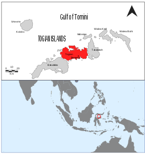
The Togian Islands are an archipelago of 56 islands and many offshore islets, situated in the Gulf of Tomini, off the coast of Central Sulawesi, in Indonesia. The largest islands are Batudaka, Togean, Talatako and Una-Una. There are 59 villages on the islands, with one settled by the Bajau people, more commonly known as the sea gypsies.
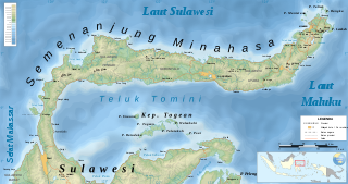
The Minahasa Peninsula, also spelled Minahassa, is one of the four principal peninsulas on the Indonesian island of Sulawesi. It stretches north from the central part of the island, before turning to the east and forming the northern boundary of the Gulf of Tomini and the southern boundary of the Celebes Sea.
The Derawan Islands are in the province of East Kalimantan in Indonesia. They consist of 31 islands, most well known among these are the islands of Derawan, Kakaban, Maratua, and Sangalaki. There are also numerous submerged reefs and islets. They are located in the Sulawesi Sea, on the coastal shelf of East Kalimantan. The islands are part of the Berau Regency.

Seko is a district of North Luwu Regency, South Sulawesi, Indonesia. A mountainous district with a population of 13,000 people, it is a relatively isolated region from the rest of the regency and province.
Paguyaman River is a river in Gorontalo (province), Sulawesi island, Indonesia, about 1900 km northeast of capital Jakarta.

Poso Regency is a regency of Central Sulawesi Province of Indonesia. It covers an area of 7,112.25 km2, and had a population of 209,228 at the 2010 Census and 244,875 at the 2020 Census; the official estimate as at mid 2021 was 248,345. The principal town lies at Poso.

Tojo Una-Una Regency is a regency of Central Sulawesi, Indonesia. The administrative centre is at Ampana town, on the Sulawesi 'mainland'. While the Regency includes a considerable area on the eastern peninsula of Sulawesi, it also includes the Togian Islands in the Gulf of Tomini. The total area covers 5,721.51 km2 and the population was 134,945 at the 2010 Census and 163,829 at the 2020 Census; the official estimate as at mid 2021 was 166,339.
Bajaw is the language of the Bajaw, widely known as the 'sea gypsies' of Maritime Southeast Asia. Differences exist between the language's varieties in western Sabah, Mapun in southern Philippines, eastern Sabah, and across Sulawesi to Maluku.
Una-Una is an Indonesian island, part of the Togian Islands in the Gulf of Tomini.

Gorontalo is a province of Indonesia on the island of Sulawesi. Located on the Minahasa Peninsula, Gorontalo was formerly part of the province of North Sulawesi until its inauguration as a separate province on 5 December 2000. In Indonesian history, the only Indonesian President from the Gorontaloan people is the third President of the Republic of Indonesia, Prof. DR. Ing. Bacharuddin Jusuf Habibie. His father, Alwi Abdul Jalil Habibie, comes from the "Habibie" clan.

Mendanau is an island in the Bangka Belitung province of Indonesia. Located about 6 km off the west coast of Belitung and 20 km from the town of Tanjung Pandan, it is the fourth largest island in the province after Bangka, Belitung and Lepar with an area of approximately 113 square kilometers. Administratively it forms - with about 27 satellite islands - the Selat Nasik District of Belitung Regency, and it is home to 5,674 people at the 2020 Census, mostly spread in 3 settlements.
Masalembu is an island located in the Java Sea and is the largest island in the Masalembu Islands. It is administered by the Masalembu District of the Sumenep Regency which is centered on the island of Madura and is made up of two administrative villages of Sukajeruk and Massalima.
Togean is an Indonesian island in the Gulf of Tomini, part of the Togean Archipelago. It is administratively part of the Tojo Una-Una Regency of Central Sulawesi, consisting largely of the Togean District with the Tanjung Pude village, part of the Una Una District, sitting on the western part of the island.

Modisi is a town in North Sulawesi Province, Indonesia. it lies on the left bank of the Modisi River
