
Raes Junction is a small settlement in New Zealand, located at the intersection of State Highways 8 and 90, in the lower South Island. The highways which meet at the junction are the main routes to the Clutha valley for travellers from Dunedin and Invercargill respectively.

The Clutha River is the second longest river in New Zealand and the longest in the South Island. It flows south-southeast 338 kilometres (210 mi) through Central and South Otago from Lake Wānaka in the Southern Alps to the Pacific Ocean, 75 kilometres (47 mi) south west of Dunedin. It is the highest volume river in New Zealand, and the swiftest, with a catchment of 21,960 square kilometres (8,480 sq mi), discharging a mean flow of 614 cubic metres per second (21,700 cu ft/s). The river is known for its scenery, gold-rush history, and swift turquoise waters. A river conservation group, the Clutha Mata-Au River Parkway Group, is working to establish a regional river parkway, with a trail, along the entire river corridor.
Tangiteroria is a small rural community in the North Island of New Zealand. It is located halfway between Whangārei and Dargaville on State Highway 14 on the banks of the Northern Wairoa river.
West Otago is the local name given to part of the region of Otago, New Zealand, lying close to the border with Southland. It is administratively connected to South Otago, but is geographically separated from it by a range of hills known as the Blue Mountains. The largest settlements in West Otago are Tapanui and Heriot, and other localities within the area include Moa Flat, Edievale, Crookston, Merino Downs, and Waikoikoi. The area described as West Otago is sometimes extended to include Lawrence, Clinton, and Beaumont. The ghost town of Kelso also lies within West Otago. Other notable features of the area include Conical Hill and Landslip Hill, the latter being a major fossil-bearing formation.

The Manuherikia River is located in Otago in the South Island of New Zealand. It rises in the far north of the Maniototo, with the West Branch draining the eastern side of the St Bathans Range, and the East Branch draining the western flanks of the Hawkdun Range. The river continues southwest through the wide Manuherikia Valley to its confluence with the Clutha River at Alexandra. During the 1860s the Manuherikia was one of the centres of the Central Otago Gold Rush.
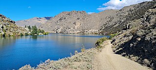
The Cromwell Gorge is a steep gorge cut by the former Clutha River in the Central Otago region of New Zealand's South Island. It winds 19 km (12 mi) between the Dunstan and Cairnmuir Mountains, linking the townships of Cromwell and Clyde. It is one of three substantial river gorges in Central Otago, the others being the Kawarau Gorge to the west of Cromwell, and the Roxburgh Gorge south of Alexandra.
Inch Clutha is a large, flat island sitting in the delta between the Matau (northern) and Koau (southern) branches of the Clutha River, downstream from the town of Balclutha in the South Island of New Zealand. Approximately 10 kilometres (6 mi) long and 3 kilometres (2 mi) wide, the fertile but flood-prone land of the island is extensively farmed. The island was formed in 1878 after a massive flood changed the course of the Clutha, which had formerly reached the ocean 4 km to the south at Port Molyneux.
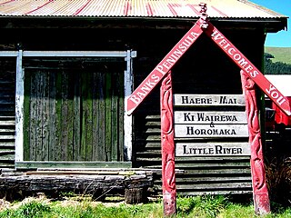
Little River is a town on Banks Peninsula in the Canterbury region of New Zealand.

Beaumont is a small town in inland Otago, in the South Island of New Zealand. It is located on the Clutha River / Mata-Au six kilometres southeast of Raes Junction, between Roxburgh and Balclutha. Beaumont is connected to Milton and Roxburgh by State Highway 8.

The Nevis Bungy is a bungee jumping platform in the Southern Alps near Queenstown in New Zealand's South Island. It is the third highest bungee jumping platform in the world at a height of 134 metres. It is suspended by high-tension cords, which are fixed at both ends on either side of the Nevis River valley. Its glass floor allows spectators to watch others jump. This makes it a main tourist attraction for those visiting Queenstown.

The Roaring Meg hydro scheme refers to two small hydro electricity power stations fed by the Roaring Meg Dam. The scheme is located next to the Roaring Meg Stream in the Kawarau Gorge, near Cromwell, New Zealand. Roaring Meg is owned and operated by Pioneer Energy.

The Balclutha Road Bridge, which spans the Clutha River in Balclutha, South Otago, New Zealand, is one of the best-known road bridges in New Zealand's South Island. The bridge is often simply known as "The Clutha Bridge", despite the fact that there are numerous bridges across the country's second longest river.

Kelso is an abandoned small settlement in Otago, New Zealand, located ten kilometres north of Tapanui on the Crookston Burn, close to its junction with the larger Pomahaka River. Its population during the 1960s and 1970s was close to 300, with most of its economy based on sheep farming. A small dairy factory was a focal point in the village's early years.
The Huxley River is in the South Island of New Zealand. It feeds into the Hopkins River which in turn feeds into Lake Ōhau.

The Kawarau Gorge is a major river gorge created by the Kawarau River in Central Otago, in the South Island of New Zealand. The towns of Queenstown and Cromwell are linked by State Highway 6 through the gorge.
The Edison River is a river of the Westland District of New Zealand. It arises in the Solution Range near Mount Elliot and flows north-west and north into the Mahitahi River.
The Kauru River is a river of North Otago, New Zealand. A tributary of the Kakanui River, it rises in the east of the Kakanui Mountains and flows into that river west of Kia Ora.
The Teviot River is a river in New Zealand, a tributary of the Clutha River.

The Southern District Health Board was a district health board which provided healthcare to an area covering the southern half of the South Island of New Zealand. In July 2022, the Southern DHB was dissolved as part of a nationwide overhaul of the district health board system. Its former functions and responsibilities were taken over by Te Whatu Ora.
