Beaver Creek, Texas | |
|---|---|
 Beaver Creek  Beaver Creek | |
| Coordinates: 30°26′57″N96°33′43″W / 30.44917°N 96.56194°W | |
| Country | United States |
| State | Texas |
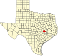
| County | Burleson |
| Area | |
• Total | 3.14 sq mi (8.13 km2) |
| • Land | 3.10 sq mi (8.04 km2) |
| • Water | 0.035 sq mi (0.09 km2) |
| Elevation | 282 ft (86 m) |
| Population (2020) | |
• Total | 910 |
| Time zone | UTC-6 (Central (CST)) |
| • Summer (DST) | UTC-5 (CDT) |
| ZIP Code | 77836 (Caldwell) |
| Area code | 979 |
| FIPS code | 48-07042 |
| GNIS feature ID | 2805743 [2] |
Beaver Creek is an unincorporated community and census-designated place (CDP) in Burleson County, Texas, United States. It was first listed as a CDP in the 2020 census with a population of 910. [3]
Contents
It is southeast of the center of the county, 12 miles (19 km) southeast of Caldwell, the county seat.