Beech Creek, Oregon

Last updated

Beech Creek
USA Oregon location map.svg
Red pog.svg
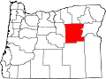
Beech Creek
Location within Oregon
Coordinates: 44°37′9.5″N119°8′56″W / 44.619306°N 119.14889°W / 44.619306; -119.14889
Country United States
State Oregon
County Grant
Elevation
4,410 ft (1,340 m)
Time zone UTC-8 (Pacific (PST))
  Summer (DST) UTC-7 (PDT)
ZIP codes
97856
GNIS feature ID1137877 [1]

Beech Creek is an unincorporated community in Grant County, Oregon. It is located at the intersection of U.S. Route 395 and County Road 27.

History

The name of Beech Creek originates from the stream of the same name; itself named for an early settler in the area. According to Oregon Geographic Names , "it seemed appropriate to name it after Beech Creek because it was near the headwaters of that stream." The post office was established on January 26, 1900, and James T. Berry was the first postmaster. [2] The post office closed in 1955. [3]

Related Research Articles

Big Creek may refer to:

Simpson is an unincorporated community in Taylor County, West Virginia, United States. It is the hometown of Randal McCloy, sole survivor of the 2006 Sago Mine disaster at Sago in Upshur County.

<span class="mw-page-title-main">Beech Creek (Pennsylvania)</span>

Beech Creek is a 27.3-mile-long (43.9 km) tributary of Bald Eagle Creek in Centre and Clinton counties, in Pennsylvania in the United States.

<span class="mw-page-title-main">Eagle Creek, Oregon</span> Unincorporated community in the state of Oregon, United States

Eagle Creek is an unincorporated community in Clackamas County, Oregon, United States. It is located seven miles southwest of Sandy, seven miles north of Estacada, and five miles southeast of Carver, at the junction of Oregon Routes 224 and 211, on the Clackamas River.

<span class="mw-page-title-main">Days Creek, Oregon</span> Unincorporated community in the state of Oregon, United States

Days Creek is an unincorporated community and census-designated place in Douglas County, Oregon, United States. At the 2010 census it had a population of 272.

Merlin is an unincorporated community and census-designated place (CDP) in Josephine County, Oregon, United States. As of the 2010 census it had a population of 1,615. The area is known for sport fishing and whitewater rafting on the Rogue River. Merlin's ZIP code is 97532.

<span class="mw-page-title-main">Lake Creek, Oregon</span> Unincorporated community in the state of Oregon, United States

Lake Creek is an unincorporated community about 20 miles (32 km) east of Medford, in Jackson County, Oregon, United States. The community takes its name from Lake Creek, an important local stream.

<span class="mw-page-title-main">Walton, Oregon</span> Unincorporated community in the state of Oregon, United States

Walton is an unincorporated community in Lane County, Oregon, United States. It is located halfway between Eugene and Florence on Oregon Route 126.

<span class="mw-page-title-main">Gales Creek, Oregon</span> Unincorporated community in the state of Oregon, United States

Gales Creek is an unincorporated community in Washington County, Oregon, United States on Oregon Route 8 northwest of Forest Grove in the foothills of the Oregon Coast Range.

Belva is an unincorporated community and census-designated place in west Nicholas County and north Fayette County, West Virginia, United States; while the CDP only includes the Nicholas County portion, the Fayette County portion is considered part of the community. The town is situated at the bottomland surrounding the convergence of Bells Creek with Twentymile Creek and, subsequently, Twenty Mile Creek with the Gauley River. Belva is also the location of the convergence of two state highways: West Virginia Route 16 and West Virginia Route 39.

<span class="mw-page-title-main">New Pine Creek, Oregon</span> Unincorporated community in the state of Oregon, United States

New Pine Creek is a census-designated place and unincorporated community in Lake County, Oregon, United States. As of the 2010 census, it had a population of 120. it has a post office with a ZIP code 97635. New Pine Creek lies on U.S. Route 395 at the Oregon–California border, just north of New Pine Creek, California, and east of Goose Lake.

<span class="mw-page-title-main">Service Creek, Oregon</span> Unincorporated community in the state of Oregon, United States

Service Creek is an unincorporated community in Wheeler County, in the U.S. state of Oregon. Service Creek lies on Oregon Route 19 near its intersection with Oregon Route 207. It is also near the mouth of a stream, Service Creek, formerly Sarvis Creek, that empties into the John Day River.

Culp Creek is an unincorporated community in Lane County, Oregon, United States, southeast of Cottage Grove on the Row River. It lies on Row River Road between Dorena and Disston.

Willowcreek is an unincorporated village in Malheur County, Oregon, United States. It is about 11 miles (18 km) northwest of Vale on U.S. Route 26. The village has a combined store and café, and the region's elementary school. Willowcreek is located at 44.114605°N 117.364349°W. Today Willowcreek has a Vale mailing address, although the nearest post office is in nearby Jamieson.

Beech Creek is an unincorporated community located in Muhlenberg County, Kentucky, United States.

Foots Creek is an unincorporated community and census-designated place (CDP) in Jackson County, in the U.S. state of Oregon. It lies along Oregon Route 99 near the mouth of Foots Creek, where it empties into the Rogue River. Interstate 5 and Valley of the Rogue State Park are on the side of the river opposite Foots Creek.

The Little River is a tributary of the Coast Fork Willamette River in the U.S. state of Oregon. Rising along the Calapooya Divide near the border between Lane and Douglas counties, it flows generally west-northwest to meet the Big River. The combined Big and Little rivers form the Coast Fork near Black Butte. The butte is a dark-colored mountain, the site of a former mine, and the site of a former post office.

Garoutte Creek is a tributary of the Little River in the U.S. state of Oregon. Rising along the Calapooya Divide near the border between Lane and Douglas counties, it flows generally northeast to meet the larger stream near Black Butte. The butte is a dark-colored mountain, the site of a former mine, and the site of a former post office. Little River joins Big River a few miles downstream to form the Coast Fork Willamette River.

The Warm Fork Spring River is a stream in Oregon County, Missouri and northern Fulton County, Arkansas. The stream begins in western Oregon County at the confluence of Howell Creek and Elk Creek and the stream becomes the Spring River at its confluence with the cold springwaters of Mammoth Spring in northern Fulton County.

<span class="mw-page-title-main">Arbuckle District, Mason County, West Virginia</span> Magisterial district in West Virginia, United States

Arbuckle Magisterial District is one of ten magisterial districts in Mason County, West Virginia, United States. The district was originally established as a civil township in 1863, and converted into a magisterial district in 1872. In 2020, Arbuckle District was home to 1,054 people.

References

  1. U.S. Geological Survey Geographic Names Information System: Beech Creek, Oregon
  2. McArthur, Lewis L. (1992). Oregon Geographic Names (sixth edition). Oregon Historical Society Press. p. 58. ISBN   0-87595-236-4.
  3. "Beech Creek: Ghost Town & ELO". Geocaching. April 12, 2014. Retrieved July 31, 2017.