References
- ↑ "Dixie (historical)". Geographic Names Information System . United States Geological Survey, United States Department of the Interior. May 22, 1986. Retrieved March 5, 2011.
- 1 2 3 McArthur, Lewis A.; McArthur, Lewis L. (2003) [1928]. Oregon Geographic Names (7th ed.). Portland, Oregon: Oregon Historical Society Press. p. 293. ISBN 978-0875952772.
44°32′00″N118°34′39″W / 44.533214°N 118.577446°W
Municipalities and communities of Grant County, Oregon, United States | ||
|---|---|---|
| Cities | 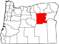 | |
| Unincorporated communities | ||
| Ghost towns | ||
| Footnotes | ‡This populated place also has portions in an adjacent county or counties | |
| | This Grant County, Oregon state location article is a stub. You can help Wikipedia by expanding it. |