Courtrock, Oregon

Last updated

Courtrock
USA Oregon location map.svg
Red pog.svg
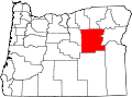
Courtrock
Location within Oregon
Coordinates: 44°38′27″N119°22′5″W / 44.64083°N 119.36806°W / 44.64083; -119.36806
Country United States
State Oregon
County Grant
Elevation
3,810 ft (1,160 m)
Time zone UTC-8 (Pacific (PST))
  Summer (DST) UTC-7 (PDT)
ZIP codes
97864
GNIS feature ID1159372 [1]

Courtrock is an unincorporated community in Grant County, Oregon.

History

The community was named for a nearby formation known as Courthouse Rock. The Courtrock post office was established in April 1926, and closed on May 31, 1953. Viola A. Lauder served as the first postmaster. [2]

Related Research Articles

<span class="mw-page-title-main">Rhododendron, Oregon</span> Unincorporated community in the state of Oregon, United States

Rhododendron is an unincorporated community in Clackamas County, Oregon, United States. It is located within the Mount Hood Corridor, between Government Camp and Zigzag on U.S. Route 26. It is one of the communities that make up the Villages at Mount Hood.

<span class="mw-page-title-main">Mount Hood, Oregon</span> Unincorporated community in the state of Oregon, United States

Mount Hood is an unincorporated community and census-designated place (CDP) in Hood River County, Oregon, United States, about 3 miles (5 km) northeast of Parkdale on Oregon Route 35. As of the 2010 census it had a population of 286. Mount Hood is the terminus of Oregon Route 281, the Hood River Highway.

<span class="mw-page-title-main">Alvadore, Oregon</span> Unincorporated community in the state of Oregon, United States

Alvadore is an unincorporated community in Lane County, Oregon, United States, located nine miles northwest of downtown Eugene and one mile northeast of Fern Ridge Reservoir.

<span class="mw-page-title-main">Mulino, Oregon</span> Unincorporated community in the state of Oregon, United States

Mulino, Oregon is a hamlet and census-designated place (CDP) located in Clackamas County, Oregon, United States, on Oregon Route 213 between the cities of Oregon City and Molalla. As of the 2010 census it had a population of 2,103.

<span class="mw-page-title-main">Prospect, Oregon</span> Unincorporated community in the state of Oregon, United States

Prospect is an unincorporated community and census-designated place (CDP) in Jackson County, in the U.S. state of Oregon. It lies along Oregon Route 62 on the Rogue River, in the Rogue River – Siskiyou National Forest. As of the 2010 census it had a population of 455.

<span class="mw-page-title-main">Vida, Oregon</span> Former unincorporated community in Oregon, United States

Vida is an unincorporated community in Lane County, Oregon, United States. It is located on Oregon Route 126 and the McKenzie River.

<span class="mw-page-title-main">Stafford, Oregon</span> Unincorporated community in Oregon, United States

Stafford is an unincorporated community, classified as a hamlet, in Clackamas County, Oregon, United States. It is a census-designated place (CDP), with a population of 1,577 as of the 2010 census. The community covers approximately 15.7 km2 located in a rough triangle south of Lake Oswego, east of Tualatin, and west of West Linn. Students in the area attend the schools of the West Linn-Wilsonville School District.

<span class="mw-page-title-main">Lewis A. McArthur</span> American historian

Lewis Ankeny McArthur, known as "Tam" McArthur, was an executive for Pacific Power and Light Company. He was also the secretary for the Oregon Geographic Board for many years and the author of Oregon Geographic Names. His book, now in its seventh edition, is a comprehensive source of information on the origins and history of Oregon place names. It is a standard reference book in libraries throughout Oregon and the Pacific Northwest. Tam McArthur Rim in the Cascade Mountains is named in his honor.

<span class="mw-page-title-main">Triangle Lake, Oregon</span> Unincorporated community in the state of Oregon, United States

Triangle Lake is an unincorporated community in Lane County, Oregon, United States. It is about 25 miles (40 km) west of Junction City on Oregon Route 36, on the southwest side of the lake of same name. Lake Creek, a tributary of the Siuslaw River, enters and exits the lake. Triangle Lake is closely linked to the unincorporated community of Blachly, on the northeast side of the lake, and the two communities share the K-12 Triangle Lake School, the only school in Blachly School District. Triangle Lake is served by the Blachly post office and the Pioneer Telephone Cooperative.

<span class="mw-page-title-main">Lake Creek, Oregon</span> Unincorporated community in the state of Oregon, United States

Lake Creek is an unincorporated community about 20 miles (32 km) east of Medford, in Jackson County, Oregon, United States. The community takes its name from Lake Creek, an important local stream.

<span class="mw-page-title-main">Index of Oregon-related articles</span>

The following is an alphabetical list of articles related to the U.S. state of Oregon.

<span class="mw-page-title-main">Greenleaf, Oregon</span> Unincorporated community in Oregon, United States

Greenleaf is an unincorporated community in Lane County, Oregon, United States. Greenleaf lies on Oregon Route 36 east of Deadwood and west of Triangle Lake.

<span class="mw-page-title-main">Rainbow, Oregon</span> Unincorporated community in the state of Oregon, United States

Rainbow is an unincorporated community in Lane County, Oregon, United States. It lies off Oregon Route 126, northeast of Eugene. Rainbow's elevation is 1,211 feet (369 m). A post office was established on July 1, 1924, and closed August 31, 1937. The post office got its name from the rainbow trout that swim in the McKenzie River.

<span class="mw-page-title-main">Manhattan Beach State Recreation Site</span>

Manhattan Beach State Recreation Site is a state park in the U.S. state of Oregon. Administered by the Oregon Parks and Recreation Department, the park is open to the public and is fee-free. Amenities at the park, which is 2 miles (3 km) north of Rockaway Beach along U.S. Route 101, include picnicking, fishing, and a Pacific Ocean beach.

London Springs is an unincorporated community in Lane County, Oregon, United States. It lies 11.33 miles (18.23 km) south-southwest of Cottage Grove at an elevation of 896 feet (273 m). London Springs is near the Coast Fork Willamette River, south of Cottage Grove Lake.

<span class="mw-page-title-main">Goldson, Oregon</span> Unincorporated community in the state of Oregon, United States

Goldson is an unincorporated community in Lane County, Oregon, United States on Oregon Route 36 near Bear Creek, about 3.5 miles (5.6 km) from Cheshire. Goldson post office was established in 1891 and named for the first postmaster, J. M. Goldson. It ran until 1934. The community's elevation is 404 feet (123 m).

<span class="mw-page-title-main">Cushman, Oregon</span> Unincorporated community in the state of Oregon, United States

Cushman is an unincorporated community in Lane County, Oregon, United States. It is located on the north bank of the Siuslaw River on Oregon Route 126, between Tiernan and Florence.

Latham is an unincorporated community in Lane County, Oregon, United States. It is located on Interstate 5 about 2 miles south of downtown Cottage Grove. The community was named after the politician Milton S. Latham. The post office operated for about ten years, from September 16, 1878 to February 14, 1888. James J. Comstock was its first postmaster. Latham is now served by the Cottage Grove post office.

Linslaw is an unincorporated community in Lane County, Oregon, United States. It is located about eight miles west of Walton on Oregon Route 126 next to the Siuslaw River.

Tiernan is an unincorporated community in Lane County, Oregon, United States. It is about five miles west of Mapleton on Oregon Route 126 near the Siuslaw River and within the Siuslaw National Forest.

References

  1. U.S. Geological Survey Geographic Names Information System: Courtrock, Oregon
  2. McArthur, Lewis L. (1992). Oregon Geographic Names (sixth edition). Oregon Historical Society Press. p. 211. ISBN   0-87595-236-4.