
Tunica Resorts, formerly known as Robinsonville until 2005, is a census-designated place (CDP) in northern Tunica County, Mississippi, United States, north of the county seat of Tunica. The community is situated mostly between the Mississippi River and U.S. Route 61, along the border with Arkansas. The population as of the 2020 census was 2,132.

Oregon City, formerly Bloomingdale and Hengy, is a ghost town located between Oroville and Cherokee in Butte County, California. One of the first mining camps in the county, it was established in the autumn of 1848 by a party of Oregonians, who came to California over the Applegate and Lassen trails. Little more than a year later their captain, Peter H. Burnett, became the first civil Governor of California. For a time, Oregon City prospered as a gold mining and supply center, then it declined into virtual oblivion. It lies 1,184 feet (361 m) above mean sea level.
Robinsonville may refer to:
Sylvan-Highlands is a neighborhood of Portland, Oregon, United States located on the west side of the West Hills.
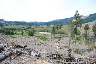
Valsetz was an unincorporated community and timber company town in Polk County, Oregon, United States, west of Falls City in the Central Oregon Coast Range. It no longer exists.

Champion is an unincorporated community in the town of Green Bay in Brown County, Wisconsin, United States. It is part of the Green Bay Metropolitan Statistical Area. The town hall for the town of Green Bay is located in Champion and the National Shrine of Our Lady of Champion is located just east of Champion.

Remote is an unincorporated hamlet in Coos County in the U.S. state of Oregon. It lies near the confluence of Sandy Creek with the Middle Fork Coquille River.

Copperfield is a former town in Baker County, in the U.S. state of Oregon. It is on the west bank of the Snake River and the north bank of Pine Creek, downstream of a feature of the Snake River known as The Oxbow. Copperfield Park, managed by Idaho Power, occupies the former town site. The Geographic Names Information System also lists Copperfield as a variant name for Oxbow, Oregon.
Kerby is an unincorporated community and census-designated place (CDP) in Josephine County, Oregon, United States, north of Cave Junction on U.S. Route 199. As of the 2010 census the population was 595. Despite its population and numerous businesses, it is often listed in tourist guides as a ghost town, because of the number of historic buildings left from its days as a gold-mining town. Kerby came into existence between 1854 and 1857.
Shedd is an unincorporated community and census-designated place (CDP) in Linn County, Oregon, United States, on Oregon Route 99E. As of the 2010 census it had a population of 204.
Pocahontas is a historic former community in Baker County, Oregon, United States. It lies northwest of Baker City along Pocahontas Road near the Elkhorn Mountains.
Horse Heaven is a ghost town in Jefferson County in the U.S. state of Oregon. The settlement, which had a post office from 1938 to 1946, is 46 miles (74 km) east of Madras and 18 miles (29 km) east of Ashwood.

Saint Benedict is the name of the post office at Mount Angel Abbey in Marion County, Oregon, United States.
Norway is an unincorporated community in Coos County, Oregon, United States, located between Coquille and Myrtle Point on Oregon Route 42, near the Coquille River.
Sparta is an unincorporated community in Baker County, Oregon, United States. It was named for Sparta, Illinois, by William H. Packwood, a prominent Oregon pioneer who visited the gold diggings at the Powder River there in 1871.

Dolph is an unincorporated community in Tillamook County, Oregon, United States, near the Yamhill County line. It lies at the junction of Oregon Route 22 and Oregon Route 130 between Grande Ronde and Hebo, on the Little Nestucca River. It is within the Siuslaw National Forest in the Northern Oregon Coast Range.
Gravelford is an unincorporated community in Coos County, Oregon, United States. It is about 8 miles (13 km) northeast of Myrtle Point, at the confluence of the North Fork Coquille River and the East Fork Coquille River.
Hamlet is an unincorporated community in Clatsop County, Oregon, United States. It is located approximately six miles southeast of Necanicum, in the Northern Oregon Coast Range near the confluence of the North Fork Nehalem River and the Little North Fork Nehalem River. It is surrounded by units of the Clatsop State Forest.

Divide is a ghost town in Lane County, Oregon, United States, located southwest of Cottage Grove, near Interstate 5. A post office in Douglas County near a train station on the Southern Pacific Railroad was established on May 31, 1900, and it was closed on January 15, 1921. In 1909, the post office was relisted as a Lane County post office. It may have been moved across county borders, or its county may have changed during a shift in the border between Lane and Douglas counties.

Blitzen is a ghost town in the Catlow Valley of southern Harney County, Oregon.

