Izee, Oregon | |
|---|---|
 Izee  Izee | |
| Coordinates: 44°04′01″N119°23′10″W / 44.067°N 119.386°W | |
| Country | United States |
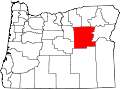
| State | Oregon |
| County | Grant |
| Elevation | 4,101 ft (1,250 m) |
| Time zone | UTC-8 (Pacific (PST)) |
| • Summer (DST) | UTC-7 (PDT) |
| ZIP code | 97873 |
| Area codes | 458 and 541 |
| GNIS feature ID | 1144149 [1] |
Izee is an unincorporated community in Grant County, Oregon, United States. [1] Its post office operated from November 6, 1889, to July 31, 1954, and the first postmaster was Carlos W. Bonham. [2] Located on the South Fork John Day River, Izee is a ranching community and was so named because a rancher there branded his cattle with the letters I. Z. [3] The schoolhouse and grange building still stand as of 2019. [4]