Dale, Oregon

Last updated
The Dale Service Station Dale, Oregon.jpg
The Dale Service Station

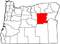
Dale is an unincorporated community in Grant County, Oregon, United States. [1] It is located on U.S. Route 395 within the Umatilla National Forest about 17 miles south of Ukiah. [2] It is near the Umatilla-Grant County border just south of the 45th parallel north. [2]

Contents

The first post office at this locale was established in 1887 and named Dorman after James W. Dorman, the first postmaster. [3] The name was changed to Dale in 1891. [3] The office may have been moved south from its original location in Umatilla County and it was shown as being in Grant County by 1903. [3] According to the compiler of Oregon Geographic Names , who did not think that the local terrain resembled a dale, "The name Dale as applied to this locality may have had a significance other than topographic." [3] Mail for Dale is now handled by the Ukiah post office, ZIP code 97880. [4]

In 1940, Dale had a service station and store that still serves the community today. [5] [6] Dale Ranger Station was open by 1911 and closed sometime before 2008. [7] [8]

See also

Related Research Articles

Umatilla County, Oregon County in Oregon, United States

Umatilla County is one of the 36 counties in the U.S. state of Oregon. As of the 2020 census, the population was 80,075. Hermiston is the largest city in Umatilla County, but Pendleton remains the county seat. Umatilla County is part of the Hermiston-Pendleton, OR Micropolitan Statistical Area, which has a combined population of 92,261. It is included in the eight-county definition of Eastern Oregon.

Ukiah, Oregon City in Oregon, United States

Ukiah (/juːkaɪʌ/) is a city in Umatilla County, Oregon, United States. The population was 186 at the 2010 census. It is part of the Hermiston-Pendleton Micropolitan Statistical Area. It was named by an early settler after the town of Ukiah, California.

Blue Mountains (Pacific Northwest) Mountain range in Oregon and Washington, United States

</ref>

Meacham, Oregon Unincorporated community in the State of Oregon, United States

Meacham is an unincorporated community in Umatilla County, Oregon. It is located on the old alignment of U.S. Route 30 off Interstate 84, in the Umatilla National Forest, near Emigrant Springs State Heritage Area and the route of the Oregon Trail. It is part of the Pendleton–Hermiston Micropolitan Statistical Area.

Austin is an unincorporated community, considered a ghost town, in Grant County, Oregon, United States. It is located north of Oregon Route 7, near the Middle Fork John Day River in the Malheur National Forest.

Umatilla National Forest National forest in the U.S. states of Oregon and Washington

The Umatilla National Forest, in the Blue Mountains of northeast Oregon and southeast Washington, covers an area of 1.4 million acres (5,700 km2). In descending order of land area the forest is located in parts of Umatilla, Grant, Columbia, Morrow, Wallowa, Union, Garfield, Asotin, Wheeler, and Walla Walla counties. More than three-quarters of the forest lies in the state of Oregon. Forest headquarters are located in Pendleton, Oregon. There are local ranger district offices in Heppner and Ukiah in Oregon, and in Pomeroy and Walla Walla in Washington.

Fox, Oregon Unincorporated community in the State of Oregon, United States

Fox is an unincorporated community in Grant County, Oregon, United States, on U.S. Route 395 south of Long Creek.

Umapine, Oregon Unincorporated community in the State of Oregon, United States

Umapine (/uməpaɪn/) is a census-designated place and unincorporated community in Umatilla County, Oregon, United States, two miles from the Oregon-Washington border. The traditional boundary covers a wide area. It has a population of 315 people as of 2010. The community is part of the Pendleton–Hermiston Micropolitan Statistical Area. The current economy is supported by agriculture, including wheat and hay farms, apple orchards, and an increasing number of vineyards. The main establishments in the town are Tate's Umapine Market, The Umapine Creamery and the Waterhole Tavern.

Ritter, Oregon Unincorporated community in the State of Oregon, United States

Ritter is an unincorporated community in Grant County, Oregon, United States, ten miles down the Middle Fork John Day River from U.S. Route 395, between Dale and Long Creek. At one time the locale was also known as Ritter Hot Springs.

Galena is an unincorporated community in Grant County, Oregon, United States, about 20 miles (32 km) from Austin Junction in the Blue Mountains. It is on the Middle Fork John Day River in the Malheur national forest. The former gold mining camp is considered a ghost town.

Susanville, Oregon

Susanville is an unincorporated community in Grant County, Oregon, United States, in the Blue Mountains about two miles up Elk Creek from Galena. The place was started as a gold mining camp in 1862 or 1864 and is now considered a ghost town.

Mountaindale, Oregon Unincorporated community in the State of Oregon, United States

Mountaindale is an unincorporated community in Washington County, Oregon, United States, about four miles northwest of North Plains. Settled in the 1850s, the small community was the longtime home of the Mountaindale Store. The area is part of Washington County Fire District 2.

Lehman Springs is an unincorporated community in Umatilla County, Oregon, United States. Lehman Springs was named after pioneer James Lehman. Its post office was established on September 8, 1899, and it closed on February 29, 1928. Lehman Springs is now served by the Ukiah post office.

Nolin is an unincorporated community in Umatilla County, Oregon, United States. Nolin is about 8 miles (13 km) southeast of Echo, next to the Umatilla River. At one time the area was known as "Happy Canyon". Adam "Ad" W. Nye, a settler of the 1860s, named the Nolin area Happy Canyon, for the spirit of the people who lived there. The name was later adopted by Pendleton Round-Up for its indoor show in commemoration of this time. Nye was County Sheriff in 1872–74. The nearby community of Nye was named for him.

Gibbon is an unincorporated community in Umatilla County, Oregon, United States. It is about 20 miles (32 km) east of Pendleton on the Umatilla Indian Reservation, near the Umatilla River.

Bingham Springs, Oregon Unincorporated community in the State of Oregon, United States

Bingham Springs is an unincorporated community in Umatilla County, Oregon, United States. It is about 8 miles (13 km) east of Gibbon in the Blue Mountains near the Umatilla River.

Tiernan is an unincorporated community in Lane County, Oregon, United States. It is about five miles west of Mapleton on Oregon Route 126 near the Siuslaw River and within the Siuslaw National Forest.

Hinkle is an unincorporated community along the Umatilla River in northwestern Umatilla County, Oregon, United States. It is south of Hermiston, near Interstate 84/U.S. Route 30 and Oregon Route 207, within the Pendleton–Hermiston Micropolitan Statistical Area. It is the site of the Union Pacific Railroad's (UP) Hinkle Locomotive Service and Repair Facility, part of the Hinkle Freight Classification Yard.

Kamela is an unincorporated community in Union County, Oregon, United States. It is located west of Interstate 84 about 20 miles northwest of La Grande.

Rieth is an unincorporated community in Umatilla County, Oregon, United States. It is south of Interstate 84/U.S. Route 30/U.S. Route 395 about 5 miles (8 km) west of Pendleton near the Umatilla River.

References

  1. "Dale". Geographic Names Information System . United States Geological Survey. November 28, 1980. Retrieved February 7, 2012.
  2. 1 2 Oregon Atlas & Gazetteer (7th ed.). Yarmouth, Maine: DeLorme. 2008. pp. 74, 78. ISBN   0-89933-347-8.
  3. 1 2 3 4 McArthur, Lewis A.; McArthur, Lewis L. (2003) [1928]. Oregon Geographic Names (7th ed.). Portland, Oregon: Oregon Historical Society Press. p. 265. ISBN   978-0875952772.
  4. "ZIP Code Lookup". United States Postal Service. Archived from the original on November 22, 2010. Retrieved February 7, 2012.
  5. Writers' Program of the Work Projects Administration in the State of Oregon (1940). Oregon: End of the Trail. American Guide Series. Portland, Oregon: Binfords & Mort. p.  419. OCLC   4874569.
  6. "Personal-Use Firewood Permits". Umatilla National Forest. Retrieved February 7, 2012.
  7. Groom, Etta (March 2005). "Pioneer Ranger Family at Dale, Oregon" (PDF). National Museum of Forest Service History Newsletter. United States Forest Service. 16 (1). Retrieved February 7, 2012.
  8. "Long Creek Eyes Dale FS Site for Campus". Blue Mountain Eagle . May 7, 2008.

Coordinates: 44°59′19″N118°56′51″W / 44.988487°N 118.947474°W / 44.988487; -118.947474