Range, Oregon

Last updated
Range
USA Oregon location map.svg
Red pog.svg
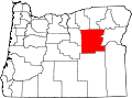
Range
Location within Oregon
Coordinates: 44°53′35″N118°58′8″W / 44.89306°N 118.96889°W / 44.89306; -118.96889 Coordinates: 44°53′35″N118°58′8″W / 44.89306°N 118.96889°W / 44.89306; -118.96889
Country United States
State Oregon
County Grant
Elevation
4,357 ft (1,328 m)
Time zone UTC-8 (Pacific (PST))
  Summer (DST) UTC-7 (PDT)
GNIS feature ID1159217 [1]

Range is an unincorporated community in Grant County, Oregon.

History

The Range post office was established on June 4, 1908, and Craig Thom was the first postmaster. It was so named due to the surrounding rangeland. [2]

Related Research Articles

Pacific Coast Ranges Series of mountain ranges along the Pacific coast of North America

The Pacific Coast Ranges are the series of mountain ranges that stretch along the West Coast of North America from Alaska south to Northern and Central Mexico. Although they are commonly thought to be the westernmost mountain range of the continental United States and Canada, the geologically distinct Insular Mountains of Vancouver Island lie further west.

Umpqua River River in Oregon, United States

The Umpqua River on the Pacific coast of Oregon in the United States is approximately 111 miles (179 km) long. One of the principal rivers of the Oregon Coast and known for bass and shad, the river drains an expansive network of valleys in the mountains west of the Cascade Range and south of the Willamette Valley, from which it is separated by the Calapooya Mountains. From its source northeast of Roseburg, the Umpqua flows northwest through the Oregon Coast Range and empties into the Pacific at Winchester Bay. The river and its tributaries flow almost entirely within Douglas County, which encompasses most of the watershed of the river from the Cascades to the coast. The "Hundred Valleys of the Umpqua" form the heart of the timber industry of southern Oregon, generally centered on Roseburg.

Blue Mountains (Pacific Northwest) Mountain range in Oregon and Washington, United States

</ref>

Cape Blanco (Oregon)

Cape Blanco is a prominent headland on the Pacific Ocean coast of southwestern Oregon in the United States, forming the westernmost point in the state. Cape Blanco extends further west than any point of land in the contiguous United States except portions of the Olympic Peninsula in Washington, including Cape Alava, the true westernmost point. The cape is part of Cape Blanco State Park and is the location of the Cape Blanco Light, first lit in 1870.

Calapooya Mountains

The Calapooya Mountains are a mountain range in Lane and Douglas counties of southwestern Oregon in the United States. The range runs for approximately 60 miles (97 km) west from the Cascade Range between Eugene on the north and Roseburg on the south.

Steens Mountain Mountain in Oregon, United States

Steens Mountain is in the southeastern part of the U.S. state of Oregon, and is a large fault-block mountain. Located in Harney County, it stretches some 50 miles (80 km) north to south, and rises from the west side the Alvord Desert at elevation of about 4,200 feet (1,300 m) to a summit elevation of 9,738 feet (2,968 m). Steens Mountain is not part of a mountain range but is properly a single mountain, the largest of Oregon's fault-block mountains.

Three Sisters Wilderness

The Three Sisters Wilderness is a wilderness area in the Cascade Range, within the Willamette and Deschutes National Forests in Oregon, United States. It comprises 286,708 acres (1,160.27 km2), making it the second largest wilderness area in Oregon, after the Eagle Cap Wilderness. It was established by the United States Congress in 1964 and is named for the Three Sisters volcanoes. The wilderness boundary encloses the Three Sisters as well as Broken Top, which is southeast of South Sister.

Oregon Jack Provincial Park is a provincial park in British Columbia, Canada located in the Clear Range west of Ashcroft. It protects the limestone canyon of Oregon Jack Creek, at the head of which is a waterfall named the Notch, above which is included a wetland area. The site was an important First Nations site and there are pictographs, culturally modified trees and a site known as the Three Sisters Rock Shelter.

Yamsay Mountain Shield volcano mountain in Oregon, U.S.

Yamsay Mountain is a large shield volcano in the Cascade Range of south-central Oregon, located about 35 miles (56 km) east of Crater Lake on the border between Klamath County and Lake County. It is part of the Cascade Volcanic Arc but is located in a mountain range 30 to 50 miles behind the main Cascade volcanic front. The best known members of this enigmatic arc are the massive shields of Newberry Volcano, about 55 miles (89 km) farther north in Oregon, and Medicine Lake Volcano, about 80 miles (130 km) south in Northern California. Yamsay is the highest volcano in the eastern arc, almost 300 feet (90 m) higher than Newberry and Medicine Lake.

Lewis A. McArthur

Lewis Ankeny McArthur, known as "Tam" McArthur, was an executive for Pacific Power and Light Company. He was also the secretary for the Oregon Geographic Board for many years and the author of Oregon Geographic Names. His book, now in its seventh edition, is a comprehensive source of information on the origins and history of Oregon place names. It is a standard reference book in libraries throughout Oregon and the Pacific Northwest. Tam McArthur Rim in the Cascade Mountains is named in his honor.

Oregon Coast Range Mountain range in Oregon, United States

The Oregon Coast Range, often called simply the Coast Range and sometimes the Pacific Coast Range, is a mountain range, in the Pacific Coast Ranges physiographic region, in the U.S. state of Oregon along the Pacific Ocean. This north-south running range extends over 200 miles (320 km) from the Columbia River in the north on the border of Oregon and Washington, south to the middle fork of the Coquille River. It is 30 to 60 miles wide and averages around 1,500 feet (460 m) in elevation above sea level. The coast range has three main sections, a Northern, Central, and Southern.

Southern Oregon Coast Range

The Southern Oregon Coast Range is the southernmost section of the Oregon Coast Range, in the Pacific Coast Ranges, located in the southwest portion of the state of Oregon, United States, roughly between the Umpqua River and the middle fork of the Coquille River, beyond which are the Klamath Mountains. To the east is the Umpqua Valley and to the west the Pacific Ocean. This approximately 55-mile (89 km)-long mountain range contains mountains as high as 3,547 feet (1,081 m) for Bone Mountain. The mountains are known locally in the Roseburg area as the Callahan Mountains, or simply as The Callahans.

Bald Peak State Scenic Viewpoint State park in Oregon, USA

Bald Peak State Scenic Viewpoint is a state park located atop Bald Peak located in Yamhill County, in the United States. The day use only park offers picnic tables and a hiking trail for views of the Willamette Valley and the Cascade Range. The state of Oregon acquired the 26 acres (11 ha) in 1931 after Yamhill and Washington counties requested a park from the state.

High Desert (Oregon) A region of the U.S. state of Oregon

The Oregon high desert is a region of the U.S. state of Oregon located east of the Cascade Range and south of the Blue Mountains, in the central and eastern parts of the state. Divided into a southern region and a northern region, the desert covers most of five Oregon counties and averages 4,000 feet (1,200 m) above sea level. The southwest region is part of the Great Basin and the southeast is the lower Owyhee River watershed. The northern region is part of the Columbia Plateau, where higher levels of rainfall allow the largest industry on private land to be the cultivation of alfalfa and hay. Public land within the region is owned primarily by the Bureau of Land Management, which manages more than 30,000 square miles (78,000 km2) including five rivers designated as Wild and Scenic.

Low Pass, Oregon Unincorporated community in the State of Oregon, United States

Low Pass is an unincorporated community in Lane County, Oregon, United States, on the Long Tom River, 5 miles (8 km) east of Blachly and 11 miles (18 km) west of Cheshire.

Munson Creek Falls State Natural Site

Munson Creek Falls State Natural Site is a state park in the U.S. state of Oregon, administered by the Oregon Parks and Recreation Department. The park contains Munson Creek Falls, which is the tallest waterfall in Oregon's Coast Range. A short hike of 0.5 miles (0.80 km) leads to views of the 319 feet (97 m) waterfall.

Trout Creek Mountains Mountain in United States of America

The Trout Creek Mountains are a remote, semi-arid Great Basin mountain range mostly in southeastern Oregon and partially in northern Nevada in the United States. The range's highest point is Orevada View Benchmark, 8,506 feet (2,593 m) above sea level, in Nevada. Disaster Peak, elevation 7,781 feet (2,372 m), is another prominent summit in the Nevada portion of the mountains.

Owyhee Mountains

The Owyhee Mountains are a mountain range in Owyhee County, Idaho and Malheur County, Oregon.

Falkner Glacier, is an east-flowing valley glacier, 4 nautical miles long, located 2 nautical miles south of Oakley Glacier in the Mountaineer Range, Victoria Land, Antarctica. The glacier descends steeply to Lady Newnes Bay where it forms a floating glacier tongue. It was named by the Advisory Committee on Antarctic Names (2008) after Kelly K. Falkner, Professor of Chemical Oceanography at Oregon State University, who served from 2006 as the first Program Director for the Antarctic Integrated System Science Program in the Division of Antarctic Sciences, Office of Antarctic Programs, National Science Foundation.

Oregon U.S. state

Oregon is a state in the Pacific Northwest region of the Western United States. The Columbia River delineates much of Oregon's northern boundary with Washington, while the Snake River delineates much of its eastern boundary with Idaho. The 42° north parallel delineates the southern boundary with California and Nevada.

References

  1. U.S. Geological Survey Geographic Names Information System: Range, Oregon
  2. McArthur, Lewis L. (1992). Oregon Geographic Names (sixth edition). Oregon Historical Society Press. p. 700. ISBN   0-87595-236-4.