
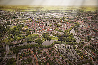
Appingedam is a city and former municipality in the northeastern Netherlands. Although there is no certainty as to the exact age of Appingedam, historical research demonstrates that the place in which the city would eventually be built had been inhabited for over a millennium. Specifically, the area in which the earliest traces of human settlements have been reported is the Wierde, a quarter located in the northern part of the city centre. Today, a narrow, winding street by the same name runs along the waterfront as a living testimony to the times gone by. The characteristic landmarks of the old Wierde are still recognisable today: the historical East-West Canal, called “Diep,” dug to the south of the Wierde, diked on both sides, still defines the unique layout of the downtown Appingedam.
Woerden is a city and a municipality in central Netherlands. Due to its central location between Amsterdam, Rotterdam, The Hague, and Utrecht, and the fact that it has rail and road connections to those cities, it is a popular town for commuters who work in those cities.

Usquert is a village in the Dutch province of Groningen. It is located in the municipality of Het Hogeland. It had a population of around 1,415 in January 2017.
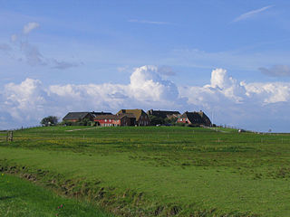
A terp, also known as a wierde, woerd, warf, warft, werf, werve, wurt or værft, is an artificial dwelling mound found on the North European Plain that has been created to provide safe ground during storm surges, high tides and sea or river flooding. The various terms used reflect the regional dialects of the North European region. In English sources, terp appears to be by far the most common term used.
Eglinton is a village in County Londonderry, Northern Ireland. It lies 5.5 miles (8.9 km) east-north-east of Derry, to which it serves as a sleeper village, and 9.5 miles (15.3 km) west-south-west of Limavady. Eglinton had a population of 3,679 people in the 2011 Census, an increase of 16% on the 2001 Census population of 3,165. It lies within Derry and Strabane district. The City of Derry Airport, also known as Eglinton Aerodrome and formerly as Londonderry Eglinton Airport, lies a short distance from the village.

Horham is a village in the county of Suffolk, in the East Anglia region of eastern England, United Kingdom. The village contains a church, St. Mary of Horham. Horham is on the B1117 road, approximately halfway between Eye and Stradbroke.

In geography, statistics and archaeology, a settlement, locality or populated place is a community in which people live. The complexity of a settlement can range from a minuscule number of dwellings grouped together to the largest of cities with surrounding urbanized areas. Settlements may include hamlets, villages, towns and cities. A settlement may have known historical properties such as the date or era in which it was first settled, or first settled by particular people.

Sparkford is a village and civil parish in the South Somerset district of Somerset, England. The parish includes the village of Weston Bampfylde.

Belpech is a commune in the Aude department in southern France.

Wasserbourg is a commune in the Haut-Rhin department in Grand Est in north-eastern France.

Pierrevillers is a commune in the Moselle department in Grand Est in north-eastern France. It is part of the urban area of Metz.

Burdaard is a village in Noardeast-Fryslân in the province of Friesland, the Netherlands. It had a population of around 1,173 in January 2017. Before 2019, the village was part of the Ferwerderadiel municipality.

Ternaard is a village in the municipality Noardeast-Fryslân located in the northeast of the province of Friesland between Dokkum and the Wadden Sea. It is the third most populous village in the municipality and had a population of 1,380 in January 2017.
Glasbury, also known as Glasbury-on-Wye, is a village and community in Powys, Wales. The village lies at an important crossing point on the River Wye, connecting the historic counties of Brecknockshire and Radnorshire, and is located just outside the Brecon Beacons National Park, north of the Black Mountains. The village is split between the communities of Glasbury and Gwernyfed. The nearest town is Hay-on-Wye, some 4 miles (6 km) to the north east. The nearest city is Hereford in England, some 25 miles (40 km) to the east. Glasbury is a popular location for river fishing, canoeing and kayaking. The population of Glasbury community in Radnorshire was 994, in 1841 it was 838.

Stitswerd is a village in the municipality of Het Hogeland, Groningen, the Netherlands. It had a population of around 45 in January 2017. Stitswerd is located on a wierde near the estuary of the former river Fivel.

Groot Wetsinge and Klein Wetsinge are two villages in the municipality of Het Hogeland in the Dutch province of Groningen. The villages are less than half a kilometre apart and are often referred to together as Wetsinge. The closest village, at a distance of less than a kilometre to Wetsinge is Sauwerd.

Oostum is a wierde on the territory of Garnwerd in the municipality of Westerkwartier in the Dutch province of Groningen. The hamlet lies on the road of the city of Groningen to Garnwerd and is part of the Pieterpad.

Obergum is part of the town Winsum that lies north of the Winsumerdiep. Originally it was a separate village. Winsum and Obergum have been connected since 1808 by the bridge De Boog.

Fransum is an old church hamlet in the municipality of Westerkwartier, Netherlands. The village in the north-east of the country contains an early 13th century Romanesque church, a farm and a house.
Udelgard Körber-Grohne was a German archaeobotanist.

