
Bulandshahr district is a district in the Meerut region in the north Indian state of Uttar Pradesh (UP), situated between the Ganga and Yamuna rivers. It is a part of the National Capital Region of India, and Bulandshahr is the district headquarters.

Chandauli district is a district of Uttar Pradesh state of India, and Chandauli town is the district headquarters. Chandauli district, a part of Varanasi Division, became a separate district on 20 May 1997.
Limerick is a village in the Canadian province of Saskatchewan within the Rural Municipality of Stonehenge No. 73 and Census Division No. 3. The village is about 150 km (94 mi) north of the US border near the towns of Lafleche and Gravelbourg. The village is named after the Irish city of Limerick.

Ujjain district is a district of Madhya Pradesh state in central India. The historic city of Ujjain is the district headquarters. The district has an area of 6,091 km2, and a population of 19,86,864, a 16.12% increase from its 2001 population of 17,10,982.

Ambala district is one of the 22 districts of Haryana state in the country of India with Ambala town serving as the administrative headquarters of the district. District Ambala lies on the North-Eastern edge of Haryana and borders Punjab and Himachal Pradesh. Ambala district is a part of Ambala Division.
Albertville is a village in the Canadian province of Saskatchewan within the Rural Municipality of Garden River No. 490 and is in Census Division No. 15. It is approximately 25 km northeast of the City of Prince Albert.
Jangipur or Zangipur is a town and a nagar panchayat in Ghazipur district in the Indian state of Uttar Pradesh.
Mehnagar is a town and a nagar panchayat in Azamgarh district in the Indian state of Uttar Pradesh.
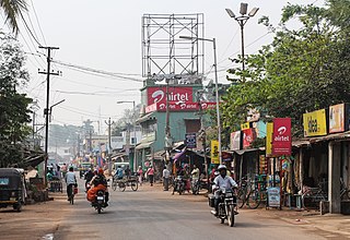
Pipili is a town and a NAC of Puri district in the Indian state of Odisha. It is famous for designing beautiful Applique handicrafts. It is a town of artisans famous for their colourful fabrics.
Vadakkuvalliyur is a panchayat town in Tirunelveli district in the Indian state of Tamil Nadu.

Piro is a nagar parishad town and corresponding community development block in Bhojpur District, in the Indian state of Bihar. Piro is 39 km from the Ara Railway Station. Jitaura is 6 km from Piro.

Shahpur is a town and a notified area in Bhojpur district in the Indian state of Bihar.
Bongadobhan is a village development committee in Baglung District in the Dhaulagiri Zone of central Nepal. At the time of the 1991 Nepal census it had a population of 4,537 and had 904 houses in the town.
Kusumkhola is a village development committee in Palpa District in the Lumbini Zone of southern Nepal. At the time of the 1991 Nepal census it had a population of 1809 people living in 349 individual households.
Mainadi is a village development committee in Palpa District in the Lumbini Zone of southern Nepal. At the time of the 1991 Nepal census it had a population of 1315 people living in 273 individual households.
Palung Mainadi is a village development committee in Palpa District in the Lumbini Zone of southern Nepal. At the time of the 1991 Nepal census it had a population of 2675 people living in 445 individual households.
Bellatti is a village in the southern state of Karnataka, India. It is located in the Shirhatti taluk of Gadag district in Karnataka.

Joypur is a community development block that forms an administrative division in the Bishnupur subdivision of the Bankura district in the Indian state of West Bengal.
Ingalahalli is a village in Dharwad district of Karnataka, India.

Jaburna is a village in Kamsaar in the Indian state of Uttar Pradesh.
