Big Bug, Arizona

Last updated

Big Bug, Arizona
Big Bug.jpg
The mining smelters in Big Bug, Arizona, circa 1900
USA Arizona location map.svg
Red pog.svg
Big Bug, Arizona
Location in the state of Arizona
Usa edcp location map.svg
Red pog.svg
Big Bug, Arizona
Big Bug, Arizona (the United States)
Coordinates: 34°18′54″N112°04′00″W / 34.31500°N 112.06667°W / 34.31500; -112.06667
Country United States
State Arizona
County Yavapai
Established1862
Abandonedcirca 1910
Named for Big Bug Creek
Elevation
[1]
3,461 ft (1,055 m)
Time zone UTC-7 (MST (no DST))
Post Office OpenedMarch 31, 1879
Post Office ClosedMarch 31, 1910

Big Bug is a ghost town in Yavapai County, Arizona, United States. The former settlement is located twelve miles southeast of Prescott and was established in 1862.

Contents

History

Big Bug has a long history of frontier life. The town was founded by Theodore Boggs during the American Civil War. Boggs' father was the former governor of Missouri, Lilburn Boggs, who helped drive the Mormons out during the Missouri Mormon War. When he was ten years old he traveled west to California, accompanied partway by the famous Donner Party. His mother was a granddaughter of the pioneer Daniel Boone.

In 1862, Boggs left California for Arizona and settled along Big Bug Creek and began working a mining claim. A mine was built with a few other buildings of necessity. A town sprang up with an average population of 100. The actual claim where the minerals were mined was a few minutes walk outside of town. In the early years only four men mined the claim, Theodore Boggs and three others.

Big Bug's population was 115 in 1890. [2]

The town had only been established a month before natives discovered the place; they attacked soon after. A post office was established in 1879 and remained in service until 1910. For a while the post office was actually Theodore Boggs' house. The assistant postmistress, Miss Dawson, delivered the mail herself on horseback throughout the town and surroundings. Gradually the town died when the mines shut down. [3]

In the 1930s, small placer miners returned to Big Bug Creek. The many large boulders in the creek had prevented the use of heavy machinery in the earlier mining, so considerable gold remained. In 1932, some 60 amateur miners were working there, some recovering as much as $300 a week, including some nuggets. [4]

The Big Bug placers produced a recorded 17,000 troy ounces (528.8 kg) of gold; the total production was around 50,000 ounces (1,417.5 kg), mostly from dredging in the 1930s and 1940s. [5] Big Bug Creek still has some indication of early mining activities, but little if anything remains of the town as of 2010. [6]

Battle of Big Bug

The Battle of Big Bug was a skirmish during the Apache Wars involving Theodore Boggs and three other miners. It occurred when Apaches attacked the mine one night. Boggs and the three others were sleeping when one awoke to the sound of their crying dog. The miner peered out and witnessed the dog, pierced with an arrow in his side. The Apaches then attempted to crush the dugout with all four of the white men inside. Big boulders were rolled down onto the structure from the mountain above. Two of the miners held a bed frame over their heads to keep the roof from caving in.

The Apaches came close and Boggs with the remaining miner manned their muskets. When the Apaches came close enough, the two stuck their rifles outside a few little portholes just dug and then they fired. Two of the Apaches were killed immediately and dropped to the ground. Caught off guard, the Apaches hastily picked up their shot fellow warriors and retreated up the mountain side. Once at the top, the Apaches cremated their dead in full view of Boggs and the others. They then continued a withdrawal from the area. Later the four went back to the town unharmed and told the alarmed residents what had happened. [6]

See also

Related Research Articles

<span class="mw-page-title-main">Congress, Arizona</span> CDP in Yavapai County, Arizona

Congress is a census-designated place (CDP) in Yavapai County, Arizona, United States. Once a gold-mining center for the Congress Mine and then a ghost town, Congress now serves as a retirement and bedroom community for nearby Wickenburg. The population was 1,811 at the 2020 census.

<span class="mw-page-title-main">Prescott Valley, Arizona</span> Town in Yavapai County, Arizona

Prescott Valley is a town located in Yavapai County, Arizona, United States, approximately 8 miles (13 km) east of Prescott. According to the 2020 United States Census, Prescott Valley has a population of 46,785 residents.

<span class="mw-page-title-main">Tortilla Flat, Arizona</span> Unincorporated community in the state of Arizona, United States

Tortilla Flat is a small unincorporated community in far eastern Maricopa County, Arizona, United States. It is located in the central part of the state, northeast of Apache Junction. It is the last surviving stagecoach stop along the Apache Trail. According to the Gross Management Department of Arizona's main U.S. Post Office in Phoenix, Tortilla Flat is presumed to be Arizona's smallest official "community" having a U.S. Post Office and voting precinct. The town has a population of 6. Tortilla Flat can be reached by vehicles on the Apache Trail, via Apache Junction.

<span class="mw-page-title-main">Crown King, Arizona</span> Unincorporated community in Yavaipai County

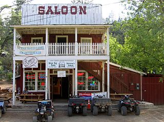
Crown King is an unincorporated community in Yavapai County, Arizona, United States, located at an elevation of 5,771 feet (1,759 m). Crown King has a ZIP Code of 86343; in 2000, the population of the 86343 ZCTA was 133. The site of a former gold mining town, Crown King is 28 miles west of Interstate 17 on Senator Highway, high in the Bradshaw Mountains. The community is named after the Crowned King mine, but the name was shortened to Crown King in 1888. Horsethief Basin Lake resides 6.5 miles southeast of Crown King on Crown King Rd/Forest 259 Rd.

<span class="mw-page-title-main">Tip Top, Arizona</span> Ghost town in Yavapai County, Arizona

Tip Top is a ghost town in Yavapai County in the U.S. state of Arizona. The town was settled in 1876 in what was then the Arizona Territory.

<span class="mw-page-title-main">Cherry, Arizona</span> Ghost town in Yavapai County, Arizona

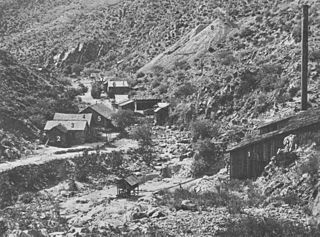
Cherry is a mining ghost town in central Yavapai County, Arizona, United States, between Dewey and Camp Verde, located at an elevation of 5,143 feet.

<span class="mw-page-title-main">Yavapai</span> Ethnic Group

The Yavapai are a Native American tribe in Arizona. Historically, the Yavapai – literally “people of the sun” – were divided into four geographical bands who identified as separate, independent peoples: the Ɖulv G’paaya, or Western Yavapai; the Yaavpe', or Northwestern Yavapai; the Gwev G’paaya, or Southeastern Yavapai; and the Wiipukpaa, or Northeastern Yavapai – Verde Valley Yavapai.

Silver mining in Arizona was a powerful stimulus for exploration and prospecting in early Arizona. Cumulative silver production through 1981 totaled 490 million troy ounces. However, only about 10% of Arizona's silver production came from silver mining. More than 80% of the state's silver was a byproduct of copper mining; other silver came as a byproduct of lead, zinc, and gold mining.

<span class="mw-page-title-main">Castle Dome Mountains</span> Landform in Yuma County, Arizona, US

The Castle Dome Mountains are a mountain range in Yuma County, Arizona, within the Kofa National Wildlife Refuge. Castle Dome Peak, the high point of the range, is a prominent butte and distinctive landmark. The peak is 3,780 feet (1,152 m) high, and is located at 33°05′04″N 114°08′36″W. Castle Dome was named by American soldiers at old Fort Yuma in the 1880s. Early Spanish explorers called the same peak Cabeza de Gigante, "Giant's Head."

<span class="mw-page-title-main">Alexandra, Arizona</span> Ghost town in Yavapai County, Arizona

Alexandra is a ghost town in Yavapai County, Arizona, United States. The ghost town was settled during the frontier days of 1875 as a mining camp until abandoned in 1896. Alexandra is ten miles east of Mayer.

Bradshaw City is a ghost town in Yavapai County, Arizona, United States. It served as a mining camp from its founding in 1863 until the late 1880s. "Bradshaw City" is the namesake of its founder, William D. Bradshaw.

Catoctin in Yavapai County, Arizona, United States was a small gold mining camp. The camp was established circa 1902 and received a post office on December 29 of the same year. It is located on upper Hassayampa River, sixteen miles southeast of Prescott. Only a handful of mining buildings and homes were constructed and on average the town was home to about twenty people. The Catoctin and Climax mines were nearby. On July 15, 1920, the post office was closed.

Cerro Colorado is a ghost town in southern Pima County, Arizona. The town is located off Arivaca Road, near Arivaca, and is best known for the massacre of mining employees by Mexican outlaws and buried treasure.

McMillenville, also known as McMillianville or McMillanville, is a populated place in Gila County, Arizona. Silver ore was discovered by chance in 1876 by Theodore H. Harris and Charles McMillen, and the town formed around the ore deposits.

<span class="mw-page-title-main">Fort Tyson</span> Historic site in La Paz County, Arizona

Fort Tyson was a privately owned fort built in 1856 by Charles Tyson in the area which is now called Quartzsite, Arizona. He built the fort to protect the local miners and water supply from the raids of the Yavapai (Mohave-Apache), a Native-American tribe. The area in which Fort Tyson was located has been known as Fort Tyson, Tyson’s Well and is now called the town of Quartzsite because of the large amount of quartz found in its surrounding areas.

<span class="mw-page-title-main">Joe Mayer</span> Arizona pioneer (1846–1909)

Joseph Mayer was an American businessman, gold prospector and pioneer who founded the town of Mayer, Arizona.

References

  1. U.S. Geological Survey Geographic Names Information System: Big Bug Creek
  2. Cram, George Franklin (1890). Cram's Universal Atlas: Geographical, Astronomical and Historical, Containing a Complete Series of Maps of Modern Geography, Illustrated by Numerous Views and Charts; the Whole Supplemented with Valuable Statistics, Diagrams, and a Complete Gazetteer of the United States. G.F. Cram. p. 349.
  3. Varney, Philip (1980). "One: Near Prescott • Ghosts of the Higher Ground". Arizona's Best Ghost Towns. Flagstaff: Northland Press. p. 9. ISBN   0873582179. LCCN   79-91724.
  4. Miller, C.W., 1999, The Automobile Gold Rush in 1930s Arizona, History of Mining in Arizona: Mining Foundation of the Southwest, v. 3
  5. Prescott Area Geological Field Guide, 1999, prepared for Earth Science Week. Copy available at Yavapai College library.
  6. 1 2 Sherman, James E; Barbara H. Sherman (1969). Ghost Towns of Arizona. University of Oklahoma Press. pp. 13–14. ISBN   0-8061-0843-6.