Bagdad, Arizona

Last updated

Bagdad, Arizona
CDP
Bagdad Arizona 01 2003.JPG
Bagdad, Arizona townscape, January 2003
Logo of Bagdad, Arizona.svg
Yavapai County incorporated areas Bagdad highlighted.svg
Location in Yavapai County and the state of Arizona
Coordinates: 34°34′38″N113°10′37″W / 34.57722°N 113.17694°W / 34.57722; -113.17694 [1]
Country United States
State Arizona
County Yavapai
Area
[2]
  Total8.06 sq mi (20.88 km2)
  Land8.06 sq mi (20.88 km2)
  Water0.00 sq mi (0.00 km2)
Elevation
[1]
3,796 ft (1,157 m)
Population
 (2020)
  Total1,932
  Density239.70/sq mi (92.55/km2)
Time zone UTC-7 (MST)
ZIP code
86321
Area code 928
FIPS code 04-05140
GNIS feature ID2407792 [1]
Website bagdadaztown.com/company-info/townsite-history/

Bagdad is a copper mining community and census-designated place (CDP) in Yavapai County, Arizona, United States, in the western part of the state. It is one of only two remaining company towns in Arizona. The population was 1,876 at the 2010 census, up from 1,578 in 2000.

Contents

Name

According to legend, the name "Bagdad" is not a misspelling of "Baghdad". Supposedly a father and son operated a small-scale copper mining operation there in the late 1800s. The father dug out the ore and the son loaded it into bags. When one bag was full he asked his father "Do you have a bag, dad?" [3] However, this is disputed and some say the name derives from the Iraqi capital, Baghdad, imagined as an epitome of wealth and luxury. [4]

Demographics

Historical population
CensusPop.Note
1930 275
1960 1,462
1970 2,07942.2%
1980 2,33112.1%
1990 1,858−20.3%
2000 1,578−15.1%
2010 1,87618.9%
2020 1,9323.0%
U.S. Decennial Census [5]

Bagdad first appeared on the 1930 U.S. Census as the Bagdad Precinct of Yavapai County. It was recorded as having a Spanish/Hispanic majority for that census [6] (the census would not separately feature that racial demographic again until 1980). With the combination of all county precincts into 3 districts in 1940, it did not formally appear again until 1960, when it reported as an unincorporated village. In 1980, it was made a census-designated place (CDP).

As of the census [7] of 2010, there were 1,876 people, 682 households, and 485 families residing in the CDP. The population density was 237.5 inhabitants per square mile (91.7/km2). There were 838 housing units at an average density of 106.1 per square mile (41.0/km2). The racial makeup of the CDP was 86.6% White, 0.5% Black or African American, 3.0% Native American, 0.3% Asian, 0.1% Pacific Islander, 6.3% from other races, and 3.3% from two or more races. 24.4% of the population were Hispanic or Latino of any race.

There were 682 households, out of which 43.4% had children under the age of 18 living with them, 57.0% were married couples living together, 5.9% had a female householder with no husband present, and 28.9% were non-families. 24.6% of all households were made up of individuals, and 3.1% had someone living alone who was 65 years of age or older. The average household size was 2.75 and the average family size was 3.29.

In the CDP, the population was spread out, with 33.1% under the age of 18, 8.6% from 18 to 24, 29.6% from 25 to 44, 24.3% from 45 to 64, and 4.4% who were 65 years of age or older. The median age was 30 years. For every 100 females, there were 123.9 males. For every 100 females age 18 and over, there were 119.0 males.

The median income for a household in the CDP was $58,277, and the median income for a family was $61,850. Males had a median income of $50,000 versus $40,506 for females. The per capita income for the CDP was $24,370. About 1.3% of families and 2.8% of the population were below the poverty line, including 4.8% of those under age 18 and 9.5% of those age 65 or over.

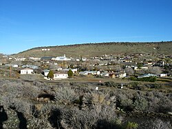
Geography and climate

According to the United States Census Bureau, the CDP has a total area of 7.9 square miles (20 km2), all land.

According to the Köppen climate classification system, Bagdad has a typical Arizona semi-arid climate, located on the boundary between BSh and BSk on climate maps. [8]

Climate data for Bagdad, Arizona (1991–2020 normals, extremes 1929–present)
MonthJanFebMarAprMayJunJulAugSepOctNovDecYear
Record high °F (°C)83
(28)
84
(29)
88
(31)
100
(38)
102
(39)
114
(46)
110
(43)
110
(43)
108
(42)
98
(37)
88
(31)
81
(27)
114
(46)
Mean maximum °F (°C)70.0
(21.1)
72.3
(22.4)
78.5
(25.8)
87.3
(30.7)
94.0
(34.4)
101.5
(38.6)
104.4
(40.2)
102.8
(39.3)
97.9
(36.6)
90.5
(32.5)
79.8
(26.6)
70.6
(21.4)
105.6
(40.9)
Average high °F (°C)57.3
(14.1)
59.0
(15.0)
64.9
(18.3)
72.0
(22.2)
80.9
(27.2)
91.2
(32.9)
94.6
(34.8)
93.2
(34.0)
87.8
(31.0)
77.2
(25.1)
65.7
(18.7)
56.4
(13.6)
75.0
(23.9)
Daily mean °F (°C)43.7
(6.5)
45.3
(7.4)
50.5
(10.3)
56.5
(13.6)
65.1
(18.4)
74.6
(23.7)
80.2
(26.8)
79.0
(26.1)
73.0
(22.8)
62.2
(16.8)
51.1
(10.6)
43.1
(6.2)
60.4
(15.8)
Average low °F (°C)30.2
(−1.0)
31.7
(−0.2)
36.0
(2.2)
41.0
(5.0)
49.3
(9.6)
58.0
(14.4)
65.8
(18.8)
64.9
(18.3)
58.3
(14.6)
47.1
(8.4)
36.5
(2.5)
29.8
(−1.2)
45.7
(7.6)
Mean minimum °F (°C)22.2
(−5.4)
23.6
(−4.7)
28.6
(−1.9)
33.8
(1.0)
40.6
(4.8)
49.5
(9.7)
59.8
(15.4)
59.8
(15.4)
50.6
(10.3)
37.9
(3.3)
27.1
(−2.7)
22.2
(−5.4)
19.8
(−6.8)
Record low °F (°C)9
(−13)
10
(−12)
17
(−8)
26
(−3)
31
(−1)
40
(4)
51
(11)
48
(9)
39
(4)
25
(−4)
18
(−8)
8
(−13)
8
(−13)
Average precipitation inches (mm)2.14
(54)
2.32
(59)
1.74
(44)
0.60
(15)
0.37
(9.4)
0.21
(5.3)
1.25
(32)
2.33
(59)
1.36
(35)
0.89
(23)
1.03
(26)
1.64
(42)
15.88
(403)
Average snowfall inches (cm)0.2
(0.51)
0.2
(0.51)
0.2
(0.51)
0.1
(0.25)
0.0
(0.0)
0.0
(0.0)
0.0
(0.0)
0.0
(0.0)
0.0
(0.0)
0.0
(0.0)
0.0
(0.0)
0.4
(1.0)
1.1
(2.8)
Average precipitation days (≥ 0.01 inch)4.74.84.72.51.81.04.86.94.12.22.53.943.9
Average snowy days (≥ 0.1 inch)0.20.50.20.20.00.00.00.00.00.00.00.31.4
Source 1: NOAA [9]
Source 2: National Weather Service [10]

Copper mine

Malachite-Quartz-Chrysocolla specimen from the Bagdad Mine Malachite-Quartz-Chrysocolla-22818.jpg
Malachite-Quartz-Chrysocolla specimen from the Bagdad Mine

In 1882, prospectors W.J. Pace and J.M. Murphy staked a claim for gold, silver, and lead along Copper Creek. In 1883, John Lawler of Prescott, Arizona paid Pace and Murphy $200 for their claims, but were unable to make a success of it. In 1907, the Giroux Syndicate purchased an option on Lawler's claims for $200,000 (equivalent to $6,000,000in 2020), with Edmond Bronson as president. However, the mine was still not able to earn a profit, and operations languished off and on for years. In 1944, the operation was purchased by John C. Lincoln, the builder of the Camelback Inn, who converted the mine entirely from underground operation to open-pit. In 1979, the operation was purchased by AMOCO Minerals, eventually owned by Cyprus Mines. [4]

Cyprus Mines Corporation operated the copper mine until Cyprus merged with Phelps Dodge. Freeport-McMoRan (which acquired Phelps Dodge in 2007) now operates the copper/molybdenum mine. This copper mine does open pit mining and runs on an around-the-clock schedule. The copper concentrate is either trucked to southern Arizona, or taken by semi to 20 miles outside of town to the BNSF Railway's Phoenix Subdivision in Hillside.[ citation needed ]

Services

Freeport-McMoRan owns all of the housing and commercial buildings in Bagdad. The town has a main shopping center named Copper Plaza, with a small Bashas' grocery store and other businesses. Copper Plaza used to have a bank, but Stockmen's Bank pulled out due to lack of profits.[ citation needed ] However, the Arizona State Credit Union and the Bashas' Associates Federal Credit Union (BAFCU) both installed ATMs inside Bashas'.[ citation needed ]

The Bagdad Community Health Center operates a medical clinic. Fry's Food and Drug operates a pharmacy in this clinic as well. [ citation needed ]

Education

Bagdad Unified School District was formed on July 1, 1930. The first graduating class from Bagdad High School was in 1945.

The Bagdad Unified School District #20 consists of a high school, elementary school, and a junior high school. The high school and junior high are merged into one. All of the teachers in the high school and junior high teach every grade level. All schools of this district are now on one campus.

Bagdad High School consists of 7th through 12th grades. Bagdad Elementary School consists of preschool through 6th grades.

The Yavapai County Free Library District operates the Bagdad Library. [11]

Transportation

Arizona State Route 96 connects Bagdad with Arizona State Route 97 and Hillside, Arizona.

See also

Related Research Articles

<span class="mw-page-title-main">Yavapai County, Arizona</span> County in Arizona, United States

Yavapai County is near the center of the U.S. state of Arizona. As of the 2020 census, its population was 236,209, making it the fourth-most populous county in Arizona. The county seat is Prescott.

<span class="mw-page-title-main">McNary, Arizona</span> CDP in Apache and Navajo Counties, Arizona

McNary is a census-designated place (CDP) in Apache and Navajo counties in the U.S. state of Arizona, on the Fort Apache Indian Reservation. The population was 528 at the 2010 census. It is a 30-minute drive from Show Low and a 10-minute drive from Pinetop-Lakeside.

<span class="mw-page-title-main">Claypool, Arizona</span> CDP in Gila County, Arizona

Claypool is a census-designated place (CDP) in Gila County, Arizona, United States. The population was 1,538 at the 2010 census, down from 1,794 at the 2000 census. It was named after W. D. Claypool, a member of both the State House of Representatives and State Senate in the 1910s and 1920s.

<span class="mw-page-title-main">Miami, Arizona</span> Town in Gila County, Arizona

Miami is a town in Gila County, Arizona, United States. Miami is a classic Western copper boom-town. Miami's old downtown has been partly renovated, and the Bullion Plaza Museum features the cultural, mining and ranching history of the Miami area.

<span class="mw-page-title-main">Morenci, Arizona</span> CDP in Greenlee County, Arizona

Morenci is a census-designated place (CDP) and company town in Greenlee County, Arizona, United States, and was founded by the Detroit Copper Mining Company of Arizona. The population was 2000 at the 2000 census and 1,489 at the 2010 census. The biggest employer in Morenci and the owner of the town is Freeport-McMoRan, the owner of the Morenci Mine, the largest copper mining operation in North America, and one of the largest copper mines in the world. The town was a site of the Arizona Copper Mine Strike of 1983. The large open-pit mine is north of the town.

<span class="mw-page-title-main">Whiteriver, Arizona</span> Census designated place in Arizona, United States

Whiteriver is a census-designated place (CDP) located on the Fort Apache Indian Reservation in Navajo County, Arizona, United States. The population was 4,104 at the 2010 census, making it the largest settlement on the Reservation.

<span class="mw-page-title-main">Ajo, Arizona</span> Community in Pima County, Arizona

Ajo is an unincorporated community in Pima County, Arizona, United States. It is the closest community to Organ Pipe Cactus National Monument. The population was 3,304 at the 2010 census. Ajo is located on State Route 85 just 43 miles (69 km) from the Mexican border.

<span class="mw-page-title-main">Green Valley, Arizona</span> CDP in Pima County, Arizona

Green Valley is an unincorporated community and census-designated place (CDP) in Pima County, Arizona, United States. The population was 22,616 at the 2020 census.

<span class="mw-page-title-main">Kearny, Arizona</span> Town in Pinal County, Arizona

Kearny is a town in Pinal County, Arizona, United States. The town was named after General Stephen Watts Kearny, who passed through the area on November 7, 1846, while leading 100 dragoons to California. According to the 2010 census, the population of the town is 1,950. The economic base of Kearny and nearby towns is the Ray mine and Hayden Smelter, both owned and operated by ASARCO.

<span class="mw-page-title-main">Ash Fork, Arizona</span> CDP in Yavapai County, Arizona

Ash Fork is a census-designated place in Yavapai County, Arizona, United States. Its population was 396 at the 2010 U.S. Census, down from 457 in 2000.

<span class="mw-page-title-main">Black Canyon City, Arizona</span> CDP in Yavapai County, Arizona

Black Canyon City is an unincorporated community and census-designated place (CDP) in Yavapai County, Arizona, United States. The population was 2,837 at the 2010 census, up from 2,697 in 2000.

<span class="mw-page-title-main">Clarkdale, Arizona</span> Town in Yavapai County, Arizona

Clarkdale is a town in Yavapai County, Arizona, United States. The Verde River flows through the town as does Bitter Creek, an intermittent tributary of the river. According to the 2010 census, the population of the town was 4,097.

<span class="mw-page-title-main">Congress, Arizona</span> CDP in Yavapai County, Arizona

Congress is a census-designated place (CDP) in Yavapai County, Arizona, United States. Once a gold-mining center for the Congress Mine and then a ghost town, Congress now serves as a retirement and bedroom community for nearby Wickenburg. The population was 1,811 at the 2020 census.

<span class="mw-page-title-main">Cornville, Arizona</span> CDP in Yavapai County, Arizona

Cornville is a census-designated place (CDP) in Yavapai County, Arizona, United States. The population as of the 2010 United States Census was 3,280, down from 3,335 at the 2000 census. For statistical purposes, the United States Census Bureau has defined Cornville as a CDP that includes the unincorporated communities of Cornville and Page Springs.

<span class="mw-page-title-main">Lake Montezuma, Arizona</span> CDP in Yavapai County, Arizona

Lake Montezuma is a census-designated place (CDP) in Yavapai County in the U.S. state of Arizona. The population was 5,111 at the 2020 census. The CDP includes the communities of Rimrock and McGuireville. Located along Interstate 17, it is 20 miles (32 km) south of Sedona and 8 miles (13 km) north of Camp Verde in central Arizona's Verde Valley.

<span class="mw-page-title-main">Mayer, Arizona</span> CDP in Yavapai County, Arizona

Mayer is a census-designated place (CDP) in Yavapai County, Arizona, United States. The population was 1,408 at the 2000 census. Mayer includes three sites listed on the National Register of Historic Places: Mayer Apartments, Mayer Business Block, and Mayer Red Brick Schoolhouse.

<span class="mw-page-title-main">Peeples Valley, Arizona</span> CDP in Yavapai County, Arizona

Peeples Valley is a census-designated place (CDP) in Yavapai County, Arizona, United States. The population was 374 at the 2000 census.

<span class="mw-page-title-main">Spring Valley, Arizona</span> CDP in Yavapai County, Arizona

Spring Valley is a census-designated place (CDP) in Yavapai County, Arizona, United States. The population was 1,019 at the 2000 census.

<span class="mw-page-title-main">Wilhoit, Arizona</span> Census-designated place in Yavapai County, Arizona, United States

Wilhoit is a census-designated place (CDP) in Yavapai County, Arizona, United States. The population was 664 at the 2000 census.

<span class="mw-page-title-main">Yarnell, Arizona</span> CDP in Yavapai County, Arizona

Yarnell is a census-designated place (CDP) in Yavapai County, Arizona, United States. The population of Yarnell was 649 at the 2010 census. Yarnell's economy is based on ranching, mining and services to travelers and retirees. Peeples Valley, three miles north, is closely linked to Yarnell.

References

  1. 1 2 3 U.S. Geological Survey Geographic Names Information System: Bagdad, Arizona
  2. "2020 U.S. Gazetteer Files". United States Census Bureau. Retrieved October 29, 2021.
  3. Cooper, Anderson. "So that's how 'bag, dad' got its name". cnn.com. Retrieved August 30, 2021.
  4. 1 2 Eppinga, Jane (Autumn 1985). "A Tale of Bagdad: Edmond B. Bronson and his Copper Mines". The Journal of Arizona History. 26 (3): 307–326. Retrieved August 30, 2021.
  5. "Census of Population and Housing". Census.gov. Retrieved June 4, 2016.
  6. Alabama Retrieved January 25, 2023
  7. "U.S. Census website". United States Census Bureau. Retrieved April 5, 2012.
  8. Climate Summary for Bagdad, Arizona
  9. "U.S. Climate Normals Quick Access – Station: Bagdad, AZ". National Oceanic and Atmospheric Administration. Retrieved March 7, 2023.
  10. "NOAA Online Weather Data – NWS Flagstaff". National Weather Service. Retrieved March 7, 2023.
  11. "Bagdad". Yavapai County Free Library District . Retrieved January 26, 2022.

Further reading